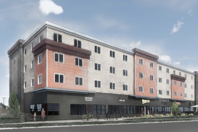
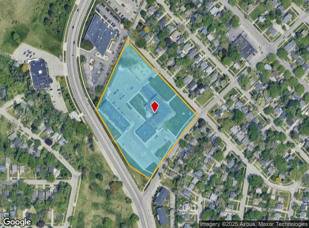
Property Record
3701 Van Buren Ave, Flint, MI 48503
Current Lease Availabilities
NEARBY LISTINGS FOR SALE OR LEASE
Property Detail
3701 Van Buren Ave
Flint, MI
Genesee
40-15-435-020
Michigan
Condominium
2.21 AC
X
Northwest Flint/Flushing
26049C0188D
Detroit
30,650 SF
DEMOGRAPHICS near 3701 Van Buren Ave
1 Mile
3 Mile
5 Mile
2024 Total Population
11,765
65,487
144,435
2029 Population
11,666
66,246
145,642
Pop Growth 2024-2029
(0.84%)
+ 1.16%
+ 0.84%
Average Age
36
39
40
2024 Total Households
4,902
27,569
60,415
HH Growth 2024-2029
(0.98%)
+ 1.07%
+ 0.79%
Median Household Inc
$41,851
$36,529
$38,387
Avg Household Size
2.30
2.20
2.30
2024 Avg HH Vehicles
1.00
1.00
1.00
Median Home Value
$69,025
$71,306
$78,642
Median Year Built
1957
1959
1960
Nearby Places
Map Layers
Map Styles
 Street
 Aerial
- Restaurants
- Banks
- Shops
- Fitness
- Groceries
PUBLIC TRANSPORTATION
COMMUTER RAIL
Flint Amtrak Station (Blue Water - Amtrak)
DRIVE
WALK
Distance
Flint Amtrak Station (Blue Water - Amtrak)
10 min
5.3 mi
AIRPORT
Bishop International
DRIVE
WALK
Distance
Bishop International
20 min
6.6 mi
Freight Ports
Port of Toledo
DRIVE
WALK
Distance
Port of Toledo
134 min
113.6 mi
Nearby Properties
Address
Land Use
TOTAL SIZE
Lot Size
Zoning
Address
Land Use
TOTAL SIZE
Lot Size
Zoning
381,509 SF
371.45 AC
PC
Address
Land Use
TOTAL SIZE
Lot Size
Zoning
Address
Land Use
TOTAL SIZE
Lot Size
Zoning
911,140 SF
Address
Land Use
TOTAL SIZE
Lot Size
Zoning
101,590 SF
5.54 AC
Address
Land Use
TOTAL SIZE
Lot Size
Zoning
54,651 SF
3.06 AC
Address
Land Use
TOTAL SIZE
Lot Size
Zoning
130,291 SF
Address
Land Use
TOTAL SIZE
Lot Size
Zoning
571,389 SF
584 AC
Address
Land Use
TOTAL SIZE
Lot Size
Zoning
585,182 SF
78.28 AC
Address
Land Use
TOTAL SIZE
Lot Size
Zoning
112,232 SF
196 AC
Address
Land Use
TOTAL SIZE
Lot Size
Zoning
144,896 SF
0.23 AC
DC
Address
Land Use
TOTAL SIZE
Lot Size
Zoning
115,556 SF
2.50 AC
DE
Address
Land Use
TOTAL SIZE
Lot Size
Zoning
99,992 SF
8.39 AC
Address
Land Use
TOTAL SIZE
Lot Size
Zoning
59,232 SF
3.65 AC
Address
Land Use
TOTAL SIZE
Lot Size
Zoning
100,000 SF
Address
Land Use
TOTAL SIZE
Lot Size
Zoning
100,750 SF
Address
Land Use
TOTAL SIZE
Lot Size
Zoning
329,849 SF
21.20 AC
CE
Address
Land Use
TOTAL SIZE
Lot Size
Zoning
247,555 SF
198 AC
Address
Land Use
TOTAL SIZE
Lot Size
Zoning
85,936 SF
12.71 AC
Address
Land Use
TOTAL SIZE
Lot Size
Zoning
68,571 SF
0.81 AC
DC
Address
Land Use
TOTAL SIZE
Lot Size
Zoning
61,892 SF
10.61 AC
Address
Land Use
TOTAL SIZE
Lot Size
Zoning
153,343 SF
14.83 AC
Address
Land Use
TOTAL SIZE
Lot Size
Zoning
48,557 SF
2.99 AC
Address
Land Use
TOTAL SIZE
Lot Size
Zoning
76,823 SF
114 AC
Address
Land Use
TOTAL SIZE
Lot Size
Zoning
23,500 SF
4.96 AC
Address
Land Use
TOTAL SIZE
Lot Size
Zoning
207,043 SF
24.20 AC
Address
Land Use
TOTAL SIZE
Lot Size
Zoning
214,422 SF
208 AC
Address
Land Use
TOTAL SIZE
Lot Size
Zoning
290,502 SF
272.83 AC
Address
Land Use
TOTAL SIZE
Lot Size
Zoning
10,212 SF
2.60 AC
UC
Address
Land Use
TOTAL SIZE
Lot Size
Zoning
94,280 SF
48.79 AC
Address
Land Use
TOTAL SIZE
Lot Size
Zoning
235,611 SF
24 AC
The World's #1 Commercial Real Estate Marketplace
Connect with us
© 2025 CoStar Group
The information above has been obtained from sources believed reliable. While we do not doubt its accuracy we have not verified it and make no guarantee, warranty or representation about it. It is your responsibility to independently confirm its accuracy and completeness. Any projections, opinions, assumptions, or estimates used are for example only and do not represent the current or future performance of the property. The value of this transaction to you depends on tax and other factors which should be evaluated by your tax, financial, and legal advisors. You and your advisors should conduct a careful, independent investigation of the property to determine to your satisfaction the suitability of the property for your needs.