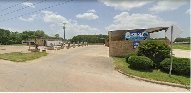
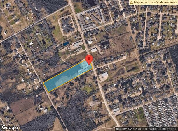
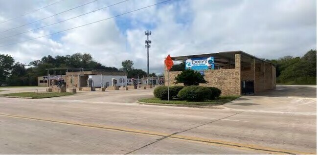
Property Record
3702 Mustang Rd, Alvin, TX 77511
NEARBY LISTINGS FOR SALE OR LEASE
Property Detail
3702 Mustang Rd
Houston-The Woodlands-Sugar Land, TX
Hooper & Wade
0480-0081-000
A0480 HOOPER & WADE TRACT 22 ACRES 8.75
Commercialnec
Brazoria
X
Texas
48039C0165K
22
2024
8.75 AC
2025
Southeast Outlier
661400
Houston
15,822 SF
DEMOGRAPHICS near 3702 Mustang Rd
1 Mile
3 Mile
5 Mile
2024 Total Population
5,001
24,872
39,700
2029 Population
5,530
27,607
43,992
Pop Growth 2024-2029
+ 10.58%
+ 11.00%
+ 10.81%
Average Age
38
38
38
2024 Total Households
1,899
9,408
14,435
HH Growth 2024-2029
+ 10.80%
+ 11.15%
+ 10.95%
Median Household Inc
$63,276
$61,684
$64,951
Avg Household Size
2.60
2.60
2.70
2024 Avg HH Vehicles
2.00
2.00
2.00
Median Home Value
$170,883
$178,899
$193,001
Median Year Built
1988
1980
1984
Nearby Places
Map Layers
Map Styles
 Street
 Aerial
- Restaurants
- Banks
- Shops
- Fitness
- Groceries
PUBLIC TRANSPORTATION
AIRPORT
William P Hobby
DRIVE
WALK
Distance
William P Hobby
35 min
19.6 mi
Freight Ports
Port of Houston
DRIVE
WALK
Distance
Port of Houston
47 min
27.7 mi
SALE & LEASE HISTORY
LISTING DATE
SALE/LEASE

Nov 11, 2022
For Sale
Nearby Properties
Address
Land Use
TOTAL SIZE
Lot Size
Zoning
Address
Land Use
TOTAL SIZE
Lot Size
Zoning
66,557 SF
8.99 AC
0065
Address
Land Use
TOTAL SIZE
Lot Size
Zoning
13.56 AC
Address
Land Use
TOTAL SIZE
Lot Size
Zoning
112,310 SF
10.81 AC
0016
Address
Land Use
TOTAL SIZE
Lot Size
Zoning
Address
Land Use
TOTAL SIZE
Lot Size
Zoning
231,096 SF
62.69 AC
0072
Address
Land Use
TOTAL SIZE
Lot Size
Zoning
209,431 SF
17.44 AC
Address
Land Use
TOTAL SIZE
Lot Size
Zoning
171,971 SF
10 AC
0062
Address
Land Use
TOTAL SIZE
Lot Size
Zoning
42,990 SF
9.74 AC
0108
Address
Land Use
TOTAL SIZE
Lot Size
Zoning
148,812 SF
10.22 AC
Address
Land Use
TOTAL SIZE
Lot Size
Zoning
116,628 SF
5.90 AC
0011
Address
Land Use
TOTAL SIZE
Lot Size
Zoning
120,516 SF
5.97 AC
Address
Land Use
TOTAL SIZE
Lot Size
Zoning
74,780 SF
5.51 AC
0034
Address
Land Use
TOTAL SIZE
Lot Size
Zoning
100,453 SF
6.02 AC
Address
Land Use
TOTAL SIZE
Lot Size
Zoning
121,249 SF
5.52 AC
0093
Address
Land Use
TOTAL SIZE
Lot Size
Zoning
46,543 SF
30.89 AC
Address
Land Use
TOTAL SIZE
Lot Size
Zoning
110,165 SF
12.32 AC
Address
Land Use
TOTAL SIZE
Lot Size
Zoning
100,754 SF
5.93 AC
Address
Land Use
TOTAL SIZE
Lot Size
Zoning
83,344 SF
4.40 AC
0002
Address
Land Use
TOTAL SIZE
Lot Size
Zoning
84,423 SF
7.87 AC
Address
Land Use
TOTAL SIZE
Lot Size
Zoning
146,535 SF
7.32 AC
Address
Land Use
TOTAL SIZE
Lot Size
Zoning
80,672 SF
4.58 AC
Address
Land Use
TOTAL SIZE
Lot Size
Zoning
83,252 SF
6.16 AC
Address
Land Use
TOTAL SIZE
Lot Size
Zoning
77,933 SF
3.67 AC
0113
Address
Land Use
TOTAL SIZE
Lot Size
Zoning
30,032 SF
61.64 AC
0009
Address
Land Use
TOTAL SIZE
Lot Size
Zoning
109,608 SF
5.58 AC
0071
Address
Land Use
TOTAL SIZE
Lot Size
Zoning
81,272 SF
5.03 AC
0015
Address
Land Use
TOTAL SIZE
Lot Size
Zoning
32,340 SF
4.38 AC
0001
Address
Land Use
TOTAL SIZE
Lot Size
Zoning
70,086 SF
3.16 AC
0115
Address
Land Use
TOTAL SIZE
Lot Size
Zoning
10,160 SF
1.57 AC
Address
Land Use
TOTAL SIZE
Lot Size
Zoning
108,807 SF
10.01 AC
0001
The World's #1 Commercial Real Estate Marketplace
Connect with us
© 2025 CoStar Group
The information above has been obtained from sources believed reliable. While we do not doubt its accuracy we have not verified it and make no guarantee, warranty or representation about it. It is your responsibility to independently confirm its accuracy and completeness. Any projections, opinions, assumptions, or estimates used are for example only and do not represent the current or future performance of the property. The value of this transaction to you depends on tax and other factors which should be evaluated by your tax, financial, and legal advisors. You and your advisors should conduct a careful, independent investigation of the property to determine to your satisfaction the suitability of the property for your needs.