Property Record
3704 Lorraine Rd, Bradenton, FL 34211

Save to a Folder
{{folder.Name}}
{{folder.ListingIds.length}} Properties
{{folder.ListingIds.length}} Property
Create a New Folder
Property Detail
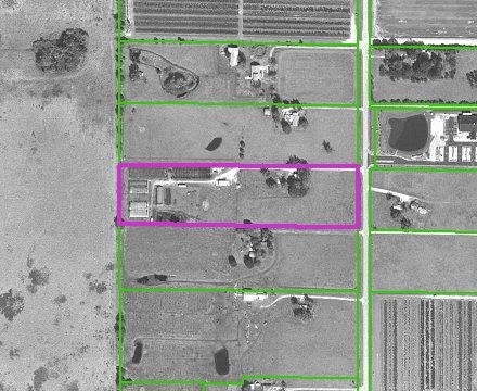
3704 Lorraine Rd
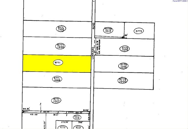
5771-0000-1
NW1/4 OF SW1/4, LESS 33 FT ON E SIDE FOR CO RD ALSO LESS THE N 660 FT & LESS THE S 330 FT P-8 PI#5771.0000/1
Religious
Manatee
A GENERAL
Florida
A Areas with a 1% annual chance of flooding and a 26% chance of flooding over the life of a 30-year mortgage.
10 AC
2023
Manatee Outlying
2025
Tampa/St Petersburg
002021
North Port-Bradenton-Sarasota, FL
17,401 SF
NEARBY LISTINGS FOR SALE OR LEASE
DEMOGRAPHICS near 3704 Lorraine Rd
1 mile
3 mile
5 mile
2025 Total Population
3,054
39,557
75,956
2030 Population
3,586
45,222
86,084
Pop Growth 2025-2030
+ 17.42%
+ 14.32%
+ 13.33%
Average Age
45
43
47
2025 Total Households
1,214
15,181
30,731
HH Growth 2025-2030
+ 17.55%
+ 14.74%
+ 13.60%
Median Household Inc
$153,055
$137,785
$124,776
Avg Household Size
2.50
2.60
2.40
2025 Avg HH Vehicles
2.00
2.00
2.00
Median Home Value
$721,371
$659,703
$644,191
Median Year Built
2011
2011
2010
Nearby Places
Map Layers
Map Styles
 Street
 Aerial
Layers
 Traffic
 Biking
Places
Listings with unknown addresses are not visible on the map
- Restaurants
- Banks
- Shops
- Fitness
- Groceries
PUBLIC TRANSPORTATION
AIRPORT
Sarasota/Bradenton International
Drive
Walk
Distance
Sarasota/Bradenton International
31 min
17.4 mi
Freight Ports
Port Manatee
Drive
Walk
Distance
Port Manatee
30 min
19.0 mi
Nearby Properties
Address
Land Use
TOTAL SIZE
Lot Size
Zoning
Address
Land Use
TOTAL SIZE
Lot Size
Zoning
602,710 SF
36.57 AC
PD-MU
Address
Land Use
TOTAL SIZE
Lot Size
Zoning
451,049 SF
55.56 AC
PDMU
Address
Land Use
TOTAL SIZE
Lot Size
Zoning
349,074 SF
15.03 AC
PD-MU
Address
Land Use
TOTAL SIZE
Lot Size
Zoning
512,380 SF
11.24 AC
PD-MU
Address
Land Use
TOTAL SIZE
Lot Size
Zoning
412,218 SF
19.09 AC
PD-MU
Address
Land Use
TOTAL SIZE
Lot Size
Zoning
409,825 SF
23.98 AC
PD-MU
Address
Land Use
TOTAL SIZE
Lot Size
Zoning
282,022 SF
21.30 AC
GC GENERA
Address
Land Use
TOTAL SIZE
Lot Size
Zoning
335,712 SF
27.91 AC
PD-MU
Address
Land Use
TOTAL SIZE
Lot Size
Zoning
349,151 SF
16.70 AC
PD-MU
Address
Land Use
TOTAL SIZE
Lot Size
Zoning
384,346 SF
56.41 AC
PD-PI
Address
Land Use
TOTAL SIZE
Lot Size
Zoning
405,307 SF
23.79 AC
PD-MU
Address
Land Use
TOTAL SIZE
Lot Size
Zoning
422,013 SF
11 AC
PD-MU
Address
Land Use
TOTAL SIZE
Lot Size
Zoning
201,213 SF
27.17 AC
PD-MU
Address
Land Use
TOTAL SIZE
Lot Size
Zoning
211,519 SF
82.32 AC
PD-MU
Address
Land Use
TOTAL SIZE
Lot Size
Zoning
125,972 SF
24.18 AC
PD-PI
Address
Land Use
TOTAL SIZE
Lot Size
Zoning
235,732 SF
49.34 AC
PD-PI
Address
Land Use
TOTAL SIZE
Lot Size
Zoning
175,410 SF
39.05 AC
PD-MU
Address
Land Use
TOTAL SIZE
Lot Size
Zoning
210,061 SF
45.14 AC
A-1 SUBURB
Address
Land Use
TOTAL SIZE
Lot Size
Zoning
158,863 SF
71.98 AC
A GENERAL
Address
Land Use
TOTAL SIZE
Lot Size
Zoning
112,961 SF
19.44 AC
Address
Land Use
TOTAL SIZE
Lot Size
Zoning
109,010 SF
7 AC
PD-MU
Address
Land Use
TOTAL SIZE
Lot Size
Zoning
125,678 SF
48.86 AC
Address
Land Use
TOTAL SIZE
Lot Size
Zoning
197,761 SF
22.73 AC
PD-R,A
Address
Land Use
TOTAL SIZE
Lot Size
Zoning
82,573 SF
16.26 AC
PD-C
Address
Land Use
TOTAL SIZE
Lot Size
Zoning
139,763 SF
6.66 AC
PD-MU
Address
Land Use
TOTAL SIZE
Lot Size
Zoning
Address
Land Use
TOTAL SIZE
Lot Size
Zoning
106,384 SF
15.55 AC
PD-MU
Address
Land Use
TOTAL SIZE
Lot Size
Zoning
78,773 SF
15.34 AC
Address
Land Use
TOTAL SIZE
Lot Size
Zoning
44,216 SF
74.28 AC
A,PD-R
Address
Land Use
TOTAL SIZE
Lot Size
Zoning
57,754 SF
8.53 AC
The World's #1 Commercial Real Estate Marketplace
Connect with us
© 2026 CoStar Group
The information above has been obtained from sources believed reliable. While we do not doubt its accuracy we have not verified it and make no guarantee, warranty or representation about it. It is your responsibility to independently confirm its accuracy and completeness. Any projections, opinions, assumptions, or estimates used are for example only and do not represent the current or future performance of the property. The value of this transaction to you depends on tax and other factors which should be evaluated by your tax, financial, and legal advisors. You and your advisors should conduct a careful, independent investigation of the property to determine to your satisfaction the suitability of the property for your needs.