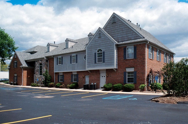
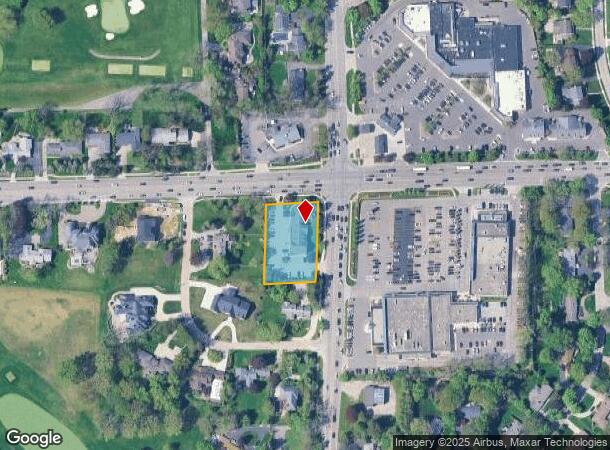
Property Record
3705 W Maple Rd, Bloomfield Hills, MI 48301
NEARBY LISTINGS FOR SALE OR LEASE
Property Detail
3705 W Maple Rd
Detroit-Warren-Dearborn, MI
W C Scott's Maple-Lasher Sub
19-33-226-006
T2N, R10E, SEC 33 W.C. SCOTT'S MAPLE-LASHER SUB N 30 FT OF LOT 8 & ALL OF LOT 12 09/30/86 FR 003 & 004
Officebuilding
Oakland
X
Michigan
26125C0517F
8-9,12
2024
0.79 AC
2024
Birmingham
150900
Detroit
12,212 SF
DEMOGRAPHICS near 3705 W Maple Rd
1 Mile
3 Mile
5 Mile
2024 Total Population
6,095
56,341
186,102
2029 Population
6,046
55,894
184,421
Pop Growth 2024-2029
(0.80%)
(0.79%)
(0.90%)
Average Age
44
44
43
2024 Total Households
2,273
21,590
78,149
HH Growth 2024-2029
(0.79%)
(0.76%)
(0.89%)
Median Household Inc
$175,978
$164,679
$105,693
Avg Household Size
2.60
2.50
2.30
2024 Avg HH Vehicles
2.00
2.00
2.00
Median Home Value
$704,072
$620,253
$402,186
Median Year Built
1959
1964
1966
Nearby Places
Map Layers
Map Styles
 Street
 Aerial
- Restaurants
- Banks
- Shops
- Fitness
- Groceries
PUBLIC TRANSPORTATION
COMMUTER RAIL
DRIVE
WALK
Distance
11 min
4.1 mi
DRIVE
WALK
Distance
15 min
8.1 mi
AIRPORT
Windsor International
DRIVE
WALK
Distance
Windsor International
54 min
30.2 mi
Detroit Metro Wayne County
DRIVE
WALK
Distance
Detroit Metro Wayne County
49 min
31.0 mi
Bishop International
DRIVE
WALK
Distance
Bishop International
68 min
48.7 mi
Nearby Properties
Address
Land Use
TOTAL SIZE
Lot Size
Zoning
Address
Land Use
TOTAL SIZE
Lot Size
Zoning
111,030 SF
0.97 AC
BI
Address
Land Use
TOTAL SIZE
Lot Size
Zoning
544,945 SF
23.89 AC
BI
Address
Land Use
TOTAL SIZE
Lot Size
Zoning
149,395 SF
1.02 AC
BI
Address
Land Use
TOTAL SIZE
Lot Size
Zoning
143,160 SF
0.84 AC
BI
Address
Land Use
TOTAL SIZE
Lot Size
Zoning
99,661 SF
0.62 AC
Address
Land Use
TOTAL SIZE
Lot Size
Zoning
167,882 SF
16.18 AC
BI
Address
Land Use
TOTAL SIZE
Lot Size
Zoning
236,140 SF
1.67 AC
BI
Address
Land Use
TOTAL SIZE
Lot Size
Zoning
289,110 SF
6.07 AC
BI
Address
Land Use
TOTAL SIZE
Lot Size
Zoning
255,136 SF
21.19 AC
AI
Address
Land Use
TOTAL SIZE
Lot Size
Zoning
83,244 SF
0.38 AC
Address
Land Use
TOTAL SIZE
Lot Size
Zoning
154,370 SF
8.80 AC
BI
Address
Land Use
TOTAL SIZE
Lot Size
Zoning
242,512 SF
6.60 AC
BI
Address
Land Use
TOTAL SIZE
Lot Size
Zoning
218,023 SF
21.80 AC
AI
Address
Land Use
TOTAL SIZE
Lot Size
Zoning
280,984 SF
11.88 AC
ERO-M
Address
Land Use
TOTAL SIZE
Lot Size
Zoning
267,393 SF
11.11 AC
BI
Address
Land Use
TOTAL SIZE
Lot Size
Zoning
79,935 SF
1.02 AC
BI
Address
Land Use
TOTAL SIZE
Lot Size
Zoning
109,570 SF
0.68 AC
BI
Address
Land Use
TOTAL SIZE
Lot Size
Zoning
245,740 SF
1.06 AC
BI
Address
Land Use
TOTAL SIZE
Lot Size
Zoning
301,276 SF
13.58 AC
AI
Address
Land Use
TOTAL SIZE
Lot Size
Zoning
80,334 SF
0.57 AC
BI
Address
Land Use
TOTAL SIZE
Lot Size
Zoning
158,374 SF
12.35 AC
BI
Address
Land Use
TOTAL SIZE
Lot Size
Zoning
93,734 SF
10.63 AC
MM
Address
Land Use
TOTAL SIZE
Lot Size
Zoning
56,867 SF
3.80 AC
BI
Address
Land Use
TOTAL SIZE
Lot Size
Zoning
52,787 SF
0.34 AC
BI
Address
Land Use
TOTAL SIZE
Lot Size
Zoning
183,090 SF
15.25 AC
RM
Address
Land Use
TOTAL SIZE
Lot Size
Zoning
53,379 SF
139.07 AC
Address
Land Use
TOTAL SIZE
Lot Size
Zoning
73,689 SF
0.60 AC
BI
Address
Land Use
TOTAL SIZE
Lot Size
Zoning
100,036 SF
1.32 AC
BI
Address
Land Use
TOTAL SIZE
Lot Size
Zoning
87,062 SF
8.74 AC
R-4
Address
Land Use
TOTAL SIZE
Lot Size
Zoning
32,688 SF
1.85 AC
The World's #1 Commercial Real Estate Marketplace
Connect with us
© 2025 CoStar Group
The information above has been obtained from sources believed reliable. While we do not doubt its accuracy we have not verified it and make no guarantee, warranty or representation about it. It is your responsibility to independently confirm its accuracy and completeness. Any projections, opinions, assumptions, or estimates used are for example only and do not represent the current or future performance of the property. The value of this transaction to you depends on tax and other factors which should be evaluated by your tax, financial, and legal advisors. You and your advisors should conduct a careful, independent investigation of the property to determine to your satisfaction the suitability of the property for your needs.