Property Record
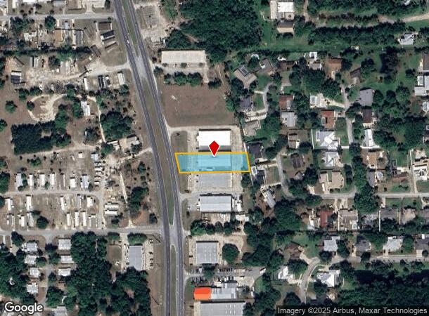
3706 N Highway 1, Cocoa, FL 32926
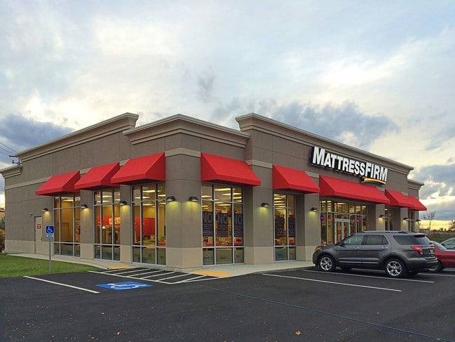

This Property Is For Sale
NEARBY LISTINGS FOR SALE OR LEASE
Property Detail
3706 N Highway 1
Palm Bay-Melbourne-Titusville, FL
Acreage & Unrec
24-36-08-00-00273.0-0000.00
PART OF GOVT LOT 1 AS DES IN ORB 2376 PG 725 EX ORB 2576 PG 1929, 4253 PG 1711
Storebuilding
Brevard
X
Florida
12009C0320H
1
2024
0.60 AC
2025
Brevard County
062115
Orlando
10,920 SF
DEMOGRAPHICS near 3706 N Highway 1
1 Mile
3 Mile
5 Mile
2024 Total Population
1,376
21,557
73,675
2029 Population
1,531
23,545
80,357
Pop Growth 2024-2029
+ 11.26%
+ 9.22%
+ 9.07%
Average Age
49
44
44
2024 Total Households
584
9,086
30,397
HH Growth 2024-2029
+ 10.96%
+ 8.99%
+ 8.85%
Median Household Inc
$78,811
$55,848
$57,003
Avg Household Size
2.40
2.30
2.30
2024 Avg HH Vehicles
2.00
2.00
2.00
Median Home Value
$285,371
$264,578
$260,789
Median Year Built
1980
1983
1982
Nearby Places
Map Layers
Map Styles
 Street
 Aerial
- Restaurants
- Banks
- Shops
- Fitness
- Groceries
PUBLIC TRANSPORTATION
AIRPORT
Melbourne Orlando International
DRIVE
WALK
Distance
Melbourne Orlando International
44 min
30.8 mi
Orlando International
DRIVE
WALK
Distance
Orlando International
46 min
38.5 mi
Nearby Properties
Address
Land Use
TOTAL SIZE
Lot Size
Zoning
Address
Land Use
TOTAL SIZE
Lot Size
Zoning
825,903 SF
94.80 AC
RU17
Address
Land Use
TOTAL SIZE
Lot Size
Zoning
413,008 SF
127.62 AC
GMLH
Address
Land Use
TOTAL SIZE
Lot Size
Zoning
335,014 SF
185.59 AC
M2
Address
Land Use
TOTAL SIZE
Lot Size
Zoning
307,934 SF
13.66 AC
RU215
Address
Land Use
TOTAL SIZE
Lot Size
Zoning
176,670 SF
13.49 AC
CG
Address
Land Use
TOTAL SIZE
Lot Size
Zoning
264,679 SF
59.90 AC
RU17
Address
Land Use
TOTAL SIZE
Lot Size
Zoning
211,753 SF
25.16 AC
CG
Address
Land Use
TOTAL SIZE
Lot Size
Zoning
96,878 SF
17.47 AC
CN
Address
Land Use
TOTAL SIZE
Lot Size
Zoning
75,552 SF
9.95 AC
PUD
Address
Land Use
TOTAL SIZE
Lot Size
Zoning
144,430 SF
14.02 AC
M2
Address
Land Use
TOTAL SIZE
Lot Size
Zoning
95,535 SF
12.69 AC
AU
Address
Land Use
TOTAL SIZE
Lot Size
Zoning
52,398 SF
9.68 AC
M2
Address
Land Use
TOTAL SIZE
Lot Size
Zoning
109,153 SF
20 AC
RU17
Address
Land Use
TOTAL SIZE
Lot Size
Zoning
65,645 SF
107.50 AC
GML
Address
Land Use
TOTAL SIZE
Lot Size
Zoning
59,448 SF
6.46 AC
RU2-15
Address
Land Use
TOTAL SIZE
Lot Size
Zoning
107,340 SF
7.64 AC
CR
Address
Land Use
TOTAL SIZE
Lot Size
Zoning
126,270 SF
20.99 AC
M2
Address
Land Use
TOTAL SIZE
Lot Size
Zoning
79,371 SF
12.44 AC
RU17
Address
Land Use
TOTAL SIZE
Lot Size
Zoning
92,025 SF
3.08 AC
RU225
Address
Land Use
TOTAL SIZE
Lot Size
Zoning
7,788 SF
200 AC
GML
Address
Land Use
TOTAL SIZE
Lot Size
Zoning
46,975 SF
10.90 AC
INL
Address
Land Use
TOTAL SIZE
Lot Size
Zoning
92,647 SF
7.02 AC
BU-2
Address
Land Use
TOTAL SIZE
Lot Size
Zoning
42,936 SF
27.69 AC
GU
Address
Land Use
TOTAL SIZE
Lot Size
Zoning
27,783 SF
8.91 AC
CN
Address
Land Use
TOTAL SIZE
Lot Size
Zoning
34,296 SF
1.41 AC
RU215
Address
Land Use
TOTAL SIZE
Lot Size
Zoning
15,320 SF
113.85 AC
AU
Address
Land Use
TOTAL SIZE
Lot Size
Zoning
108,970 SF
22.19 AC
IU
Address
Land Use
TOTAL SIZE
Lot Size
Zoning
74,632 SF
8.84 AC
M2
Address
Land Use
TOTAL SIZE
Lot Size
Zoning
100,909 SF
7.88 AC
Address
Land Use
TOTAL SIZE
Lot Size
Zoning
24,151 SF
4.62 AC
GML-H
The World's #1 Commercial Real Estate Marketplace
Connect with us
© 2026 CoStar Group
The information above has been obtained from sources believed reliable. While we do not doubt its accuracy we have not verified it and make no guarantee, warranty or representation about it. It is your responsibility to independently confirm its accuracy and completeness. Any projections, opinions, assumptions, or estimates used are for example only and do not represent the current or future performance of the property. The value of this transaction to you depends on tax and other factors which should be evaluated by your tax, financial, and legal advisors. You and your advisors should conduct a careful, independent investigation of the property to determine to your satisfaction the suitability of the property for your needs.