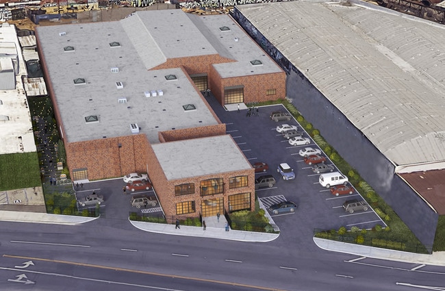
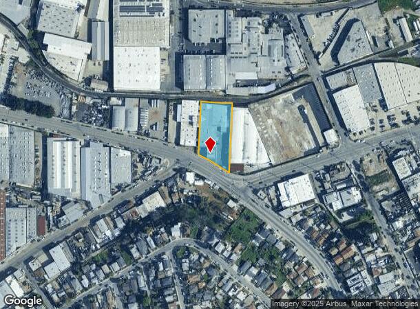
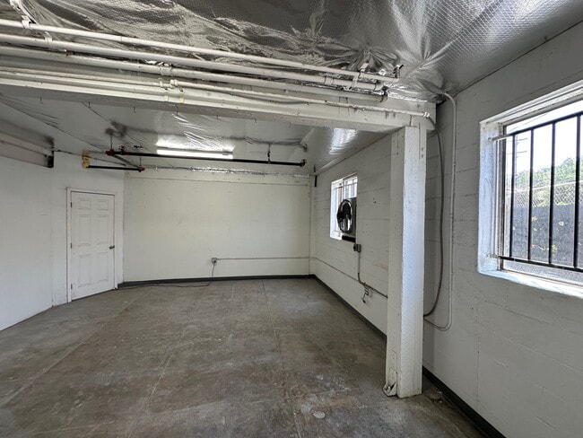
Property Record
3709 Medford St, Los Angeles, CA 90063
Current Lease Availabilities
NEARBY LISTINGS FOR SALE OR LEASE
Property Detail
3709 Medford St
Los Angeles-Long Beach-Glendale, CA
6333
5224-003-004
TRACT # 6333 W 50 FT MEASURED ON N LINE EX OF ST OF LOT 24 AND ALL OF LOT 25 BLK B
Heavyindustrial
Los Angeles
X
California
06037C1641F
24,25
2024
0.99 AC
2025
Central Los Angeles
530700
Los Angeles
28,930 SF
DEMOGRAPHICS near 3709 Medford St
1 Mile
3 Mile
5 Mile
2024 Total Population
30,310
282,754
765,105
2029 Population
29,119
271,632
738,439
Pop Growth 2024-2029
(3.93%)
(3.93%)
(3.49%)
Average Age
37
38
39
2024 Total Households
8,345
82,937
262,497
HH Growth 2024-2029
(4.21%)
(4.18%)
(3.41%)
Median Household Inc
$64,018
$61,764
$67,076
Avg Household Size
3.40
3.20
2.70
2024 Avg HH Vehicles
2.00
2.00
2.00
Median Home Value
$687,573
$719,103
$776,629
Median Year Built
1948
1951
1958
Nearby Places
Map Layers
Map Styles
 Street
 Aerial
- Restaurants
- Banks
- Shops
- Fitness
- Groceries
PUBLIC TRANSPORTATION
COMMUTER RAIL
Cal State La Metrolink Station (Metrolink San Bernardino Line - Metrolink Trains)
DRIVE
WALK
Distance
Cal State La Metrolink Station (Metrolink San Bernardino Line - Metrolink Trains)
9 min
17 min
0.9 mi
Union Station (91 Line - Southern California Regional Rail Authority (Metrolink), Antelope Valley Line - Southern California Regional Rail Authority (Metrolink), Orange County Line - Southern California Regional Rail Authority (Metrolink), Riverside Line - Southern California Regional Rail Authority (Metrolink), San Bernardino Line - Southern California Regional Rail Authority (Metrolink), Ventura County Line - Southern California Regional Rail Authority (Metrolink))
DRIVE
WALK
Distance
Union Station (91 Line - Southern California Regional Rail Authority (Metrolink), Antelope Valley Line - Southern California Regional Rail Authority (Metrolink), Orange County Line - Southern California Regional Rail Authority (Metrolink), Riverside Line - Southern California Regional Rail Authority (Metrolink), San Bernardino Line - Southern California Regional Rail Authority (Metrolink), Ventura County Line - Southern California Regional Rail Authority (Metrolink))
8 min
3.9 mi
AIRPORT
Bob Hope
DRIVE
WALK
Distance
Bob Hope
25 min
18.3 mi
Los Angeles International
DRIVE
WALK
Distance
Los Angeles International
31 min
19.7 mi
Long Beach (Daugherty Field)
DRIVE
WALK
Distance
Long Beach (Daugherty Field)
30 min
20.6 mi
Freight Ports
Port of Long Beach
DRIVE
WALK
Distance
Port of Long Beach
32 min
23.5 mi
Nearby Properties
Address
Land Use
TOTAL SIZE
Lot Size
Zoning
Address
Land Use
TOTAL SIZE
Lot Size
Zoning
635,233 SF
12.02 AC
LAR5
Address
Land Use
TOTAL SIZE
Lot Size
Zoning
513,825 SF
4.28 AC
LAC2
Address
Land Use
TOTAL SIZE
Lot Size
Zoning
534,225 SF
Address
Land Use
TOTAL SIZE
Lot Size
Zoning
460,590 SF
23.95 AC
ALMPD*
Address
Land Use
TOTAL SIZE
Lot Size
Zoning
535,949 SF
5.85 AC
LAM3
Address
Land Use
TOTAL SIZE
Lot Size
Zoning
322,080 SF
2.85 AC
LAC2
Address
Land Use
TOTAL SIZE
Lot Size
Zoning
328,737 SF
7.92 AC
LAC2
Address
Land Use
TOTAL SIZE
Lot Size
Zoning
642,160 SF
8.26 AC
LAADP
Address
Land Use
TOTAL SIZE
Lot Size
Zoning
368,058 SF
2.65 AC
LAUC (CA)
Address
Land Use
TOTAL SIZE
Lot Size
Zoning
354,299 SF
2.18 AC
LAC2
Address
Land Use
TOTAL SIZE
Lot Size
Zoning
150,608 SF
0.88 AC
LAC2
Address
Land Use
TOTAL SIZE
Lot Size
Zoning
119,455 SF
5.04 AC
LACM
Address
Land Use
TOTAL SIZE
Lot Size
Zoning
220,717 SF
2.14 AC
MPSP*
Address
Land Use
TOTAL SIZE
Lot Size
Zoning
252,559 SF
2.87 AC
LAC2
Address
Land Use
TOTAL SIZE
Lot Size
Zoning
195,526 SF
2.81 AC
LAADP
Address
Land Use
TOTAL SIZE
Lot Size
Zoning
172,072 SF
1.82 AC
LAC2
Address
Land Use
TOTAL SIZE
Lot Size
Zoning
75,589 SF
0.98 AC
LAC2
Address
Land Use
TOTAL SIZE
Lot Size
Zoning
198,958 SF
7.50 AC
LCM2*
Address
Land Use
TOTAL SIZE
Lot Size
Zoning
1,086,660 SF
26.15 AC
LAM3
Address
Land Use
TOTAL SIZE
Lot Size
Zoning
116,109 SF
0.92 AC
LACM
Address
Land Use
TOTAL SIZE
Lot Size
Zoning
112,242 SF
1.64 AC
LAM3
Address
Land Use
TOTAL SIZE
Lot Size
Zoning
65,252 SF
0.58 AC
LAM3
Address
Land Use
TOTAL SIZE
Lot Size
Zoning
342,940 SF
6.21 AC
LAM2
Address
Land Use
TOTAL SIZE
Lot Size
Zoning
99,563 SF
1.29 AC
LAM3
Address
Land Use
TOTAL SIZE
Lot Size
Zoning
116,480 SF
11.81 AC
MPC2
Address
Land Use
TOTAL SIZE
Lot Size
Zoning
122,596 SF
4.55 AC
LAM2
Address
Land Use
TOTAL SIZE
Lot Size
Zoning
66,557 SF
1.53 AC
LAUV(CA)
Address
Land Use
TOTAL SIZE
Lot Size
Zoning
155,529 SF
2.64 AC
LARD1.5
Address
Land Use
TOTAL SIZE
Lot Size
Zoning
77,778 SF
2.87 AC
ALRPD*
Address
Land Use
TOTAL SIZE
Lot Size
Zoning
213,960 SF
1.83 AC
LAUC(CA)
The World's #1 Commercial Real Estate Marketplace
Connect with us
© 2025 CoStar Group
The information above has been obtained from sources believed reliable. While we do not doubt its accuracy we have not verified it and make no guarantee, warranty or representation about it. It is your responsibility to independently confirm its accuracy and completeness. Any projections, opinions, assumptions, or estimates used are for example only and do not represent the current or future performance of the property. The value of this transaction to you depends on tax and other factors which should be evaluated by your tax, financial, and legal advisors. You and your advisors should conduct a careful, independent investigation of the property to determine to your satisfaction the suitability of the property for your needs.