Property Record
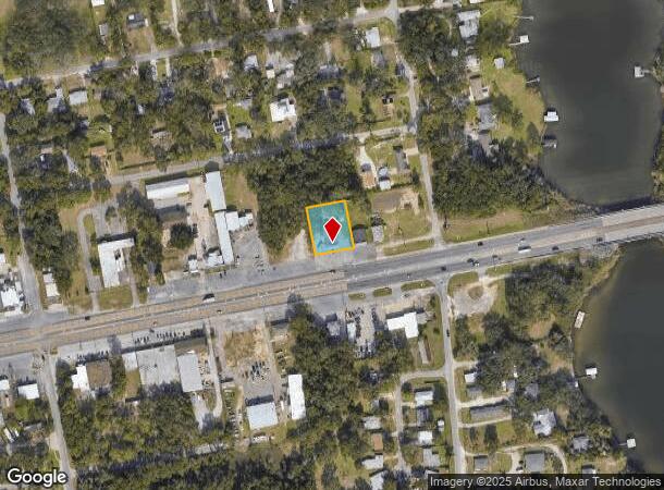
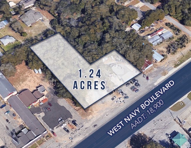
3708 W Navy Blvd, Pensacola, FL 32507
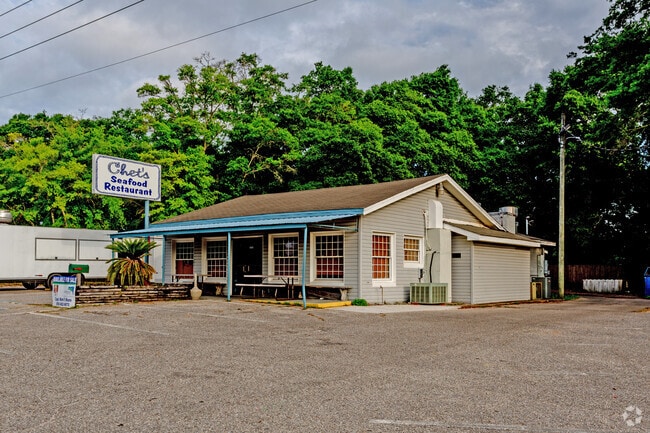
This Property Is For Sale
NEARBY LISTINGS FOR SALE OR LEASE
Property Detail
3708 W Navy Blvd
Pensacola-Ferry Pass-Brent, FL
Westerly Heights
38-2S-30-1000-004-002
LTS 5 AND 6 BLK 2 WESTERLY HEIGHTS PB 2 P 14 OR 6027 P 884 CA 161
Restaurantbuilding
Escambia
X
Florida
12033C0370G
4
2023
0.41 AC
2024
West Pensacola
002100
Pensacola
1,984 SF
DEMOGRAPHICS near 3708 W Navy Blvd
1 Mile
3 Mile
5 Mile
2024 Total Population
6,891
62,271
129,735
2029 Population
7,120
64,304
132,950
Pop Growth 2024-2029
+ 3.32%
+ 3.26%
+ 2.48%
Average Age
38
39
38
2024 Total Households
2,884
25,150
49,043
HH Growth 2024-2029
+ 3.33%
+ 3.32%
+ 2.53%
Median Household Inc
$32,091
$36,161
$43,708
Avg Household Size
2.30
2.30
2.30
2024 Avg HH Vehicles
1.00
1.00
2.00
Median Home Value
$87,640
$125,807
$157,360
Median Year Built
1960
1967
1972
Nearby Places
- Restaurants
- Banks
- Shops
- Fitness
- Groceries
PUBLIC TRANSPORTATION
AIRPORT
Pensacola International
DRIVE
WALK
Distance
Pensacola International
16 min
7.5 mi
Freight Ports
Port of Mobile
DRIVE
WALK
Distance
Port of Mobile
70 min
58.1 mi
Nearby Properties
Address
Land Use
TOTAL SIZE
Lot Size
Zoning
Address
Land Use
TOTAL SIZE
Lot Size
Zoning
6,950 SF
584.36 AC
PUB
Address
Land Use
TOTAL SIZE
Lot Size
Zoning
544,835 SF
3.29 AC
C-2,C-2A
Address
Land Use
TOTAL SIZE
Lot Size
Zoning
365,037 SF
5.79 AC
C-3
Address
Land Use
TOTAL SIZE
Lot Size
Zoning
368,724 SF
3.17 AC
C-2A
Address
Land Use
TOTAL SIZE
Lot Size
Zoning
56,970 SF
5.94 AC
WRD
Address
Land Use
TOTAL SIZE
Lot Size
Zoning
289,397 SF
12.38 AC
PUB
Address
Land Use
TOTAL SIZE
Lot Size
Zoning
207,331 SF
24.09 AC
HDR
Address
Land Use
TOTAL SIZE
Lot Size
Zoning
219,481 SF
161.44 AC
NONE
Address
Land Use
TOTAL SIZE
Lot Size
Zoning
334,324 SF
55.06 AC
PUB
Address
Land Use
TOTAL SIZE
Lot Size
Zoning
327,045 SF
7.47 AC
C-2A
Address
Land Use
TOTAL SIZE
Lot Size
Zoning
188,512 SF
11.44 AC
COM
Address
Land Use
TOTAL SIZE
Lot Size
Zoning
114,000 SF
3.23 AC
C-2,C-2A
Address
Land Use
TOTAL SIZE
Lot Size
Zoning
96,686 SF
1.06 AC
C-2A
Address
Land Use
TOTAL SIZE
Lot Size
Zoning
127,684 SF
8.24 AC
HDR
Address
Land Use
TOTAL SIZE
Lot Size
Zoning
282,738 SF
14.64 AC
PUB
Address
Land Use
TOTAL SIZE
Lot Size
Zoning
258,438 SF
48.49 AC
PUB
Address
Land Use
TOTAL SIZE
Lot Size
Zoning
99,623 SF
1.87 AC
C-2A
Address
Land Use
TOTAL SIZE
Lot Size
Zoning
169,346 SF
15.21 AC
HDR
Address
Land Use
TOTAL SIZE
Lot Size
Zoning
115,500 SF
3.48 AC
C-2
Address
Land Use
TOTAL SIZE
Lot Size
Zoning
169,963 SF
15.43 AC
HC/LI
Address
Land Use
TOTAL SIZE
Lot Size
Zoning
158,233 SF
9.15 AC
HDMU
Address
Land Use
TOTAL SIZE
Lot Size
Zoning
151,996 SF
30.44 AC
HDR
Address
Land Use
TOTAL SIZE
Lot Size
Zoning
166,204 SF
0.97 AC
C-2A
Address
Land Use
TOTAL SIZE
Lot Size
Zoning
75,877 SF
1.55 AC
WRD
Address
Land Use
TOTAL SIZE
Lot Size
Zoning
130,516 SF
4.55 AC
R-2
Address
Land Use
TOTAL SIZE
Lot Size
Zoning
55,337 SF
0.95 AC
C-2A,HC-2
Address
Land Use
TOTAL SIZE
Lot Size
Zoning
99,147 SF
5.89 AC
HDMU
Address
Land Use
TOTAL SIZE
Lot Size
Zoning
116,020 SF
4.71 AC
MDR
Address
Land Use
TOTAL SIZE
Lot Size
Zoning
81,549 SF
0.46 AC
WRD
Address
Land Use
TOTAL SIZE
Lot Size
Zoning
197,958 SF
26.08 AC
COM
The World's #1 Commercial Real Estate Marketplace
Connect with us
© 2025 CoStar Group
The information above has been obtained from sources believed reliable. While we do not doubt its accuracy we have not verified it and make no guarantee, warranty or representation about it. It is your responsibility to independently confirm its accuracy and completeness. Any projections, opinions, assumptions, or estimates used are for example only and do not represent the current or future performance of the property. The value of this transaction to you depends on tax and other factors which should be evaluated by your tax, financial, and legal advisors. You and your advisors should conduct a careful, independent investigation of the property to determine to your satisfaction the suitability of the property for your needs.