Property Record
371 8Th St, Plainwell, MI 49080

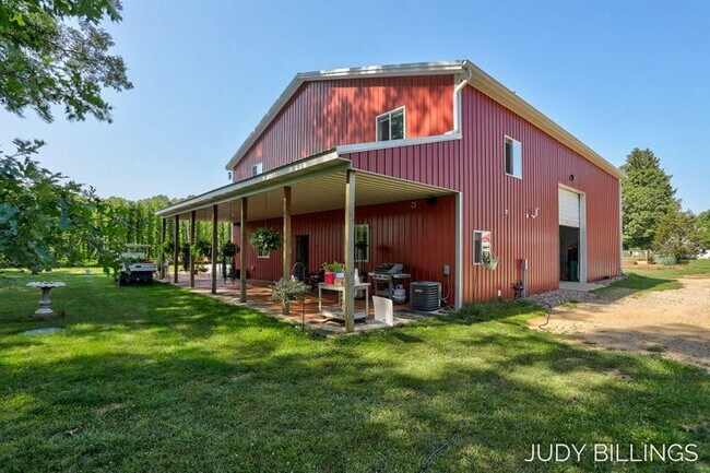
Property Detail
371 8Th St
Holland, MI
COM AT A PT 1754.5 FT N OF W 1/4 POST SEC 28 AS PL OF BEG TH E 80 RD TH S 1094.5 FT TH W 660 FT TH N 330 FT TH W 330 FT TH N 264 FT TH W 70 FT TH N 484 FT TH W 260 FT TH N 16.5 FT TO PL OF BEG SEC 28 T1N R11W TAX MAP: 23.39 AC.
08-028-036-00
ALLEGAN
Agriculturalland
Michigan
B and X Area of moderate flood hazard, usually the area between the limits of the 100-year and 500-year floods.
23.28 AC
2024
Outlying Allegan County
2025
West Michigan
032100
NEARBY LISTINGS FOR SALE OR LEASE
DEMOGRAPHICS near 371 8Th St
1 mile
3 mile
5 mile
2024 Total Population
1,366
9,925
20,245
2029 Population
1,371
9,999
20,376
Pop Growth 2024-2029
+ 0.37%
+ 0.75%
+ 0.65%
Average Age
41
41
41
2024 Total Households
536
3,868
7,890
HH Growth 2024-2029
+ 0.19%
+ 0.65%
+ 0.52%
Median Household Inc
$76,531
$77,974
$75,836
Avg Household Size
2.50
2.50
2.50
2024 Avg HH Vehicles
2.00
2.00
2.00
Median Home Value
$186,338
$179,541
$182,358
Median Year Built
1965
1976
1975
Nearby Places
Map Layers
Map Styles
 Street
 Aerial
Transit
 Traffic
 Biking
Places
Listings with unknown addresses are not visible on the map
- Restaurants
- Banks
- Shops
- Fitness
- Groceries
PUBLIC TRANSPORTATION
AIRPORT
Kalamazoo/Battle Creek International
Drive
Walk
Distance
Kalamazoo/Battle Creek International
34 min
23.3 mi
Freight Ports
Port Milwaukee
Drive
Walk
Distance
Port Milwaukee
285 min
242.7 mi
SALE & LEASE HISTORY
LISTING DATE
SALE/LEASE

Sep 25, 2023
For Sale
Nearby Properties
Address
Land Use
TOTAL SIZE
Lot Size
Zoning
Address
Land Use
TOTAL SIZE
Lot Size
Zoning
209,000 SF
29.66 AC
Address
Land Use
TOTAL SIZE
Lot Size
Zoning
189,919 SF
Address
Land Use
TOTAL SIZE
Lot Size
Zoning
164,105 SF
18.53 AC
Address
Land Use
TOTAL SIZE
Lot Size
Zoning
71,337 SF
7.04 AC
Address
Land Use
TOTAL SIZE
Lot Size
Zoning
53,661 SF
6.30 AC
Address
Land Use
TOTAL SIZE
Lot Size
Zoning
214,356 SF
23.34 AC
Address
Land Use
TOTAL SIZE
Lot Size
Zoning
48,898 SF
5.30 AC
Address
Land Use
TOTAL SIZE
Lot Size
Zoning
40,081 SF
3.92 AC
Address
Land Use
TOTAL SIZE
Lot Size
Zoning
18,388 SF
8.85 AC
R-2
Address
Land Use
TOTAL SIZE
Lot Size
Zoning
95,484 SF
8.83 AC
Address
Land Use
TOTAL SIZE
Lot Size
Zoning
76,142 SF
43.96 AC
R1
Address
Land Use
TOTAL SIZE
Lot Size
Zoning
345,769 SF
33 AC
Address
Land Use
TOTAL SIZE
Lot Size
Zoning
35,555 SF
1.10 AC
Address
Land Use
TOTAL SIZE
Lot Size
Zoning
21,047 SF
4.74 AC
Address
Land Use
TOTAL SIZE
Lot Size
Zoning
16,886 SF
1.86 AC
Address
Land Use
TOTAL SIZE
Lot Size
Zoning
39,656 SF
5.56 AC
Address
Land Use
TOTAL SIZE
Lot Size
Zoning
155,146 SF
6.31 AC
Address
Land Use
TOTAL SIZE
Lot Size
Zoning
30,220 SF
7.28 AC
Address
Land Use
TOTAL SIZE
Lot Size
Zoning
34,801 SF
0.92 AC
Address
Land Use
TOTAL SIZE
Lot Size
Zoning
41,362 SF
0.92 AC
Address
Land Use
TOTAL SIZE
Lot Size
Zoning
51,300 SF
1.84 AC
Address
Land Use
TOTAL SIZE
Lot Size
Zoning
1,000 SF
1.40 AC
R-2
Address
Land Use
TOTAL SIZE
Lot Size
Zoning
86,907 SF
3.44 AC
Address
Land Use
TOTAL SIZE
Lot Size
Zoning
115,108 SF
5.17 AC
Address
Land Use
TOTAL SIZE
Lot Size
Zoning
28,160 SF
4.38 AC
Address
Land Use
TOTAL SIZE
Lot Size
Zoning
2,606 SF
236.70 AC
AG
Address
Land Use
TOTAL SIZE
Lot Size
Zoning
396 SF
211.33 AC
Address
Land Use
TOTAL SIZE
Lot Size
Zoning
30,960 SF
5.04 AC
Address
Land Use
TOTAL SIZE
Lot Size
Zoning
63,916 SF
2.89 AC
Address
Land Use
TOTAL SIZE
Lot Size
Zoning
14,976 SF
The World's #1 Commercial Real Estate Marketplace
Connect with us
© 2026 CoStar Group
The information above has been obtained from sources believed reliable. While we do not doubt its accuracy we have not verified it and make no guarantee, warranty or representation about it. It is your responsibility to independently confirm its accuracy and completeness. Any projections, opinions, assumptions, or estimates used are for example only and do not represent the current or future performance of the property. The value of this transaction to you depends on tax and other factors which should be evaluated by your tax, financial, and legal advisors. You and your advisors should conduct a careful, independent investigation of the property to determine to your satisfaction the suitability of the property for your needs.