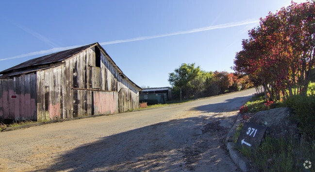
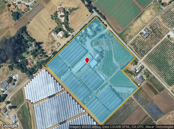
Property Record
371 Calabasas Rd, Watsonville, CA 95076

NEARBY LISTINGS FOR SALE OR LEASE
Property Detail
371 Calabasas Rd
Horticulturegrowinghousesagricultural
Santa Cruz
X
California
06087C0383E
14.54 AC
2024
Outlying Santa Cruz Cnty
2025
Santa Cruz/Watsonville
122402
Santa Cruz-Watsonville, CA
528 SF
049-171-21-000
DEMOGRAPHICS near 371 Calabasas Rd
1 Mile
3 Mile
5 Mile
2024 Total Population
2,111
38,087
84,391
2029 Population
2,028
36,901
81,932
Pop Growth 2024-2029
(3.93%)
(3.11%)
(2.91%)
Average Age
38
37
38
2024 Total Households
585
10,392
24,683
HH Growth 2024-2029
(4.44%)
(3.59%)
(3.13%)
Median Household Inc
$125,630
$84,023
$87,673
Avg Household Size
3.30
3.50
3.20
2024 Avg HH Vehicles
3.00
2.00
2.00
Median Home Value
$690,928
$666,414
$788,393
Median Year Built
1966
1975
1974
Nearby Places
Map Layers
Map Styles
 Street
 Aerial
- Restaurants
- Banks
- Shops
- Fitness
- Groceries
PUBLIC TRANSPORTATION
AIRPORT
Monterey Regional
DRIVE
WALK
Distance
Monterey Regional
41 min
31.0 mi
Norman Y Mineta San Jose International
DRIVE
WALK
Distance
Norman Y Mineta San Jose International
63 min
46.5 mi
Freight Ports
Port of Redwood City
DRIVE
WALK
Distance
Port of Redwood City
82 min
62.3 mi
SALE & LEASE HISTORY
LISTING DATE
SALE/LEASE

Sep 26, 2022
For Sale
Jan 17, 2025
For Sale
Aug 18, 2023
For Sale
Aug 11, 2023
For Sale
Nearby Properties
Address
Land Use
TOTAL SIZE
Lot Size
Zoning
Address
Land Use
TOTAL SIZE
Lot Size
Zoning
3,767 SF
6.90 AC
RM-2-R
Address
Land Use
TOTAL SIZE
Lot Size
Zoning
163,824 SF
13.98 AC
Address
Land Use
TOTAL SIZE
Lot Size
Zoning
60,392 SF
4.07 AC
RM-4
Address
Land Use
TOTAL SIZE
Lot Size
Zoning
77,449 SF
14.38 AC
R-1-6
Address
Land Use
TOTAL SIZE
Lot Size
Zoning
64,650 SF
6.04 AC
Address
Land Use
TOTAL SIZE
Lot Size
Zoning
146,574 SF
9.97 AC
Address
Land Use
TOTAL SIZE
Lot Size
Zoning
Address
Land Use
TOTAL SIZE
Lot Size
Zoning
94,674 SF
3.38 AC
Address
Land Use
TOTAL SIZE
Lot Size
Zoning
5,963 SF
7.89 AC
Address
Land Use
TOTAL SIZE
Lot Size
Zoning
8.45 AC
Address
Land Use
TOTAL SIZE
Lot Size
Zoning
8.64 AC
Address
Land Use
TOTAL SIZE
Lot Size
Zoning
59,897 SF
1.54 AC
Address
Land Use
TOTAL SIZE
Lot Size
Zoning
4.59 AC
CA
Address
Land Use
TOTAL SIZE
Lot Size
Zoning
41,700 SF
3 AC
PA
Address
Land Use
TOTAL SIZE
Lot Size
Zoning
58,495 SF
1.77 AC
Address
Land Use
TOTAL SIZE
Lot Size
Zoning
40,585 SF
2.40 AC
R-1-6
Address
Land Use
TOTAL SIZE
Lot Size
Zoning
53,672 SF
5.14 AC
Address
Land Use
TOTAL SIZE
Lot Size
Zoning
16,396 SF
5.57 AC
Address
Land Use
TOTAL SIZE
Lot Size
Zoning
61,561 SF
6.38 AC
Address
Land Use
TOTAL SIZE
Lot Size
Zoning
39,711 SF
3.88 AC
Address
Land Use
TOTAL SIZE
Lot Size
Zoning
32,962 SF
2.40 AC
Address
Land Use
TOTAL SIZE
Lot Size
Zoning
28,611 SF
1.34 AC
R16
Address
Land Use
TOTAL SIZE
Lot Size
Zoning
2.71 AC
Address
Land Use
TOTAL SIZE
Lot Size
Zoning
85,044 SF
6.95 AC
Address
Land Use
TOTAL SIZE
Lot Size
Zoning
54,327 SF
1.25 AC
RM4GH
Address
Land Use
TOTAL SIZE
Lot Size
Zoning
27.77 AC
PR
Address
Land Use
TOTAL SIZE
Lot Size
Zoning
47,647 SF
1.74 AC
Address
Land Use
TOTAL SIZE
Lot Size
Zoning
20,523 SF
3.05 AC
Address
Land Use
TOTAL SIZE
Lot Size
Zoning
133,440 SF
11.67 AC
Address
Land Use
TOTAL SIZE
Lot Size
Zoning
85,523 SF
4.36 AC
PF
The World's #1 Commercial Real Estate Marketplace
Connect with us
© 2026 CoStar Group
The information above has been obtained from sources believed reliable. While we do not doubt its accuracy we have not verified it and make no guarantee, warranty or representation about it. It is your responsibility to independently confirm its accuracy and completeness. Any projections, opinions, assumptions, or estimates used are for example only and do not represent the current or future performance of the property. The value of this transaction to you depends on tax and other factors which should be evaluated by your tax, financial, and legal advisors. You and your advisors should conduct a careful, independent investigation of the property to determine to your satisfaction the suitability of the property for your needs.