Property Record
371 Circle Of Progress Dr, Pottstown, PA 19464


NEARBY LISTINGS FOR SALE OR LEASE
Property Detail
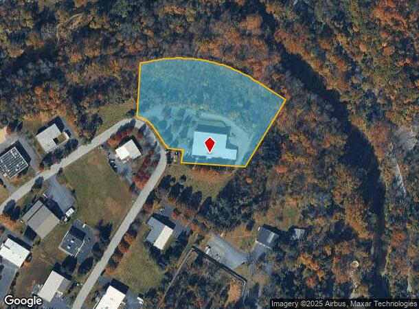
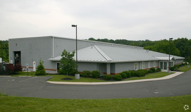
371 Circle Of Progress Dr
Philadelphia-Camden-Wilmington, PA-NJ-DE-MD
Pottstown Airport Busn Campus
16-00-22842-164
INCLUDES B61 U14 2.30 AC
Warehouse
Montgomery
X
Pennsylvania
42091C0068G
13
2024
5.07 AC
2025
West Montgomery Cty
209000
Philadelphia
15,620 SF
DEMOGRAPHICS near 371 Circle Of Progress Dr
1 Mile
3 Mile
5 Mile
2024 Total Population
3,062
40,682
94,446
2029 Population
3,100
41,342
95,959
Pop Growth 2024-2029
+ 1.24%
+ 1.62%
+ 1.60%
Average Age
42
40
40
2024 Total Households
1,316
16,409
36,316
HH Growth 2024-2029
+ 1.22%
+ 1.63%
+ 1.62%
Median Household Inc
$56,294
$62,810
$79,171
Avg Household Size
2.30
2.40
2.50
2024 Avg HH Vehicles
2.00
2.00
2.00
Median Home Value
$148,746
$180,655
$246,921
Median Year Built
1964
1955
1971
Nearby Places
Map Layers
Map Styles
 Street
 Aerial
- Restaurants
- Banks
- Shops
- Fitness
- Groceries
PUBLIC TRANSPORTATION
AIRPORT
Lehigh Valley International
DRIVE
WALK
Distance
Lehigh Valley International
62 min
34.1 mi
SALE & LEASE HISTORY
LISTING DATE
SALE/LEASE

Jul 08, 2024
For Lease
Aug 23, 2022
For Sale
Nearby Properties
Address
Land Use
TOTAL SIZE
Lot Size
Zoning
Address
Land Use
TOTAL SIZE
Lot Size
Zoning
707,965 SF
80.33 AC
RMHD
Address
Land Use
TOTAL SIZE
Lot Size
Zoning
406,166 SF
65.54 AC
C
Address
Land Use
TOTAL SIZE
Lot Size
Zoning
327,827 SF
21 AC
RMD
Address
Land Use
TOTAL SIZE
Lot Size
Zoning
172,766 SF
43.12 AC
R3
Address
Land Use
TOTAL SIZE
Lot Size
Zoning
181,947 SF
8.19 AC
RMD
Address
Land Use
TOTAL SIZE
Lot Size
Zoning
191,272 SF
48.22 AC
R2
Address
Land Use
TOTAL SIZE
Lot Size
Zoning
135,368 SF
5.31 AC
DG
Address
Land Use
TOTAL SIZE
Lot Size
Zoning
150,711 SF
21.72 AC
HB
Address
Land Use
TOTAL SIZE
Lot Size
Zoning
216,693 SF
38 AC
I1
Address
Land Use
TOTAL SIZE
Lot Size
Zoning
176,741 SF
17.40 AC
HB
Address
Land Use
TOTAL SIZE
Lot Size
Zoning
589,859 SF
53.31 AC
C2
Address
Land Use
TOTAL SIZE
Lot Size
Zoning
138,563 SF
12.98 AC
C
Address
Land Use
TOTAL SIZE
Lot Size
Zoning
165,168 SF
11.10 AC
C2
Address
Land Use
TOTAL SIZE
Lot Size
Zoning
175,151 SF
14.74 AC
RMHD
Address
Land Use
TOTAL SIZE
Lot Size
Zoning
166,912 SF
11.10 AC
R4
Address
Land Use
TOTAL SIZE
Lot Size
Zoning
104,075 SF
14 AC
SC
Address
Land Use
TOTAL SIZE
Lot Size
Zoning
70,319 SF
7.31 AC
CO
Address
Land Use
TOTAL SIZE
Lot Size
Zoning
77,944 SF
0.47 AC
D
Address
Land Use
TOTAL SIZE
Lot Size
Zoning
61,031 SF
14.54 AC
R3
Address
Land Use
TOTAL SIZE
Lot Size
Zoning
45,138 SF
9.13 AC
C
Address
Land Use
TOTAL SIZE
Lot Size
Zoning
56,774 SF
1.58 AC
C
Address
Land Use
TOTAL SIZE
Lot Size
Zoning
227,008 SF
0.79 AC
TTN
Address
Land Use
TOTAL SIZE
Lot Size
Zoning
78,770 SF
2.20 AC
RHD
Address
Land Use
TOTAL SIZE
Lot Size
Zoning
522,093 SF
23.50 AC
HM
Address
Land Use
TOTAL SIZE
Lot Size
Zoning
51,586 SF
5.77 AC
RLD
Address
Land Use
TOTAL SIZE
Lot Size
Zoning
31,680 SF
7.48 AC
R3
Address
Land Use
TOTAL SIZE
Lot Size
Zoning
63,523 SF
4 AC
FO
Address
Land Use
TOTAL SIZE
Lot Size
Zoning
86,556 SF
4.50 AC
R2
Address
Land Use
TOTAL SIZE
Lot Size
Zoning
81,285 SF
0.67 AC
D
Address
Land Use
TOTAL SIZE
Lot Size
Zoning
54,030 SF
6.25 AC
NR
The World's #1 Commercial Real Estate Marketplace
Connect with us
© 2025 CoStar Group
The information above has been obtained from sources believed reliable. While we do not doubt its accuracy we have not verified it and make no guarantee, warranty or representation about it. It is your responsibility to independently confirm its accuracy and completeness. Any projections, opinions, assumptions, or estimates used are for example only and do not represent the current or future performance of the property. The value of this transaction to you depends on tax and other factors which should be evaluated by your tax, financial, and legal advisors. You and your advisors should conduct a careful, independent investigation of the property to determine to your satisfaction the suitability of the property for your needs.