Property Record
I40 Access Rd Se, Hildebran, NC 28637
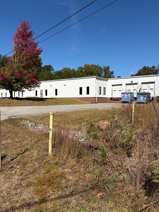
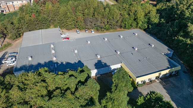
This Property Is For Sale
Property Detail
I40 Access Rd Se
36408
I40 ACCESS RD SE HILDEBRAN, NC 28637
Vacantlandnec
BURKE
GENERAL MA
North Carolina
B and X Area of moderate flood hazard, usually the area between the limits of the 100-year and 500-year floods.
1.56 AC
2025
Burke County
2025
Charlotte
021100
Hickory-Lenoir-Morganton, NC
NEARBY LISTINGS FOR SALE OR LEASE
-
-
View all Hildebran listings for sale on LoopNet.com
DEMOGRAPHICS near I40 Access Rd Se
1 mile
3 mile
5 mile
2025 Total Population
1,509
15,453
43,937
2030 Population
1,524
15,752
44,996
Pop Growth 2025-2030
+ 0.99%
+ 1.93%
+ 2.41%
Average Age
43
42
42
2025 Total Households
633
6,318
17,670
HH Growth 2025-2030
+ 1.11%
+ 2.03%
+ 2.52%
Median Household Inc
$54,072
$48,824
$57,241
Avg Household Size
2.40
2.40
2.40
2025 Avg HH Vehicles
2.00
2.00
2.00
Median Home Value
$211,389
$187,424
$224,772
Median Year Built
1975
1975
1977
Nearby Places
Map Layers
Map Styles
 Street
 Aerial
Transit
 Traffic
 Biking
Places
Listings with unknown addresses are not visible on the map
- Restaurants
- Banks
- Shops
- Fitness
- Groceries
Nearby Properties
Address
Land Use
TOTAL SIZE
Lot Size
Zoning
Address
Land Use
TOTAL SIZE
Lot Size
Zoning
7,240 SF
INDUSTRIAL
Address
Land Use
TOTAL SIZE
Lot Size
Zoning
73,872 SF
NO ZONING
Address
Land Use
TOTAL SIZE
Lot Size
Zoning
301,264 SF
19.88 AC
I
Address
Land Use
TOTAL SIZE
Lot Size
Zoning
73,702 SF
13.37 AC
C-2
Address
Land Use
TOTAL SIZE
Lot Size
Zoning
173,730 SF
16.80 AC
IND
Address
Land Use
TOTAL SIZE
Lot Size
Zoning
272,735 SF
21.83 AC
IND
Address
Land Use
TOTAL SIZE
Lot Size
Zoning
85,988 SF
9.67 AC
ED
Address
Land Use
TOTAL SIZE
Lot Size
Zoning
10,086 SF
8.61 AC
R-5
Address
Land Use
TOTAL SIZE
Lot Size
Zoning
240,210 SF
11.64 AC
I
Address
Land Use
TOTAL SIZE
Lot Size
Zoning
29.21 AC
R-2
Address
Land Use
TOTAL SIZE
Lot Size
Zoning
51,668 SF
CENTRAL BU
Address
Land Use
TOTAL SIZE
Lot Size
Zoning
151,117 SF
26.59 AC
GENERAL MA
Address
Land Use
TOTAL SIZE
Lot Size
Zoning
19,107 SF
R-3 DIST -
Address
Land Use
TOTAL SIZE
Lot Size
Zoning
94,782 SF
64.41 AC
IND
Address
Land Use
TOTAL SIZE
Lot Size
Zoning
335,352 SF
55.48 AC
INDUSTRIAL
Address
Land Use
TOTAL SIZE
Lot Size
Zoning
7,860 SF
5.56 AC
R-4
Address
Land Use
TOTAL SIZE
Lot Size
Zoning
44,046 SF
4.61 AC
R-4
Address
Land Use
TOTAL SIZE
Lot Size
Zoning
6,310 SF
CENTRAL BU
Address
Land Use
TOTAL SIZE
Lot Size
Zoning
64,928 SF
24.49 AC
ED
Address
Land Use
TOTAL SIZE
Lot Size
Zoning
12,472 SF
RESIDENTIA
Address
Land Use
TOTAL SIZE
Lot Size
Zoning
91,379 SF
11.89 AC
GENERAL MA
Address
Land Use
TOTAL SIZE
Lot Size
Zoning
92,500 SF
22.91 AC
GENERAL MA
Address
Land Use
TOTAL SIZE
Lot Size
Zoning
38,464 SF
10.37 AC
GENERAL MA
Address
Land Use
TOTAL SIZE
Lot Size
Zoning
117,420 SF
13.57 AC
IND
Address
Land Use
TOTAL SIZE
Lot Size
Zoning
103,630 SF
3.63 AC
IND
Address
Land Use
TOTAL SIZE
Lot Size
Zoning
42,950 SF
6.55 AC
CENTRAL BU
Address
Land Use
TOTAL SIZE
Lot Size
Zoning
131,144 SF
10.76 AC
I
Address
Land Use
TOTAL SIZE
Lot Size
Zoning
16.24 AC
INDUSTRIAL
Address
Land Use
TOTAL SIZE
Lot Size
Zoning
41,764 SF
8.63 AC
C-4
Address
Land Use
TOTAL SIZE
Lot Size
Zoning
99,738 SF
4.73 AC
I
The World's #1 Commercial Real Estate Marketplace
Connect with us
© 2026 CoStar Group
The information above has been obtained from sources believed reliable. While we do not doubt its accuracy we have not verified it and make no guarantee, warranty or representation about it. It is your responsibility to independently confirm its accuracy and completeness. Any projections, opinions, assumptions, or estimates used are for example only and do not represent the current or future performance of the property. The value of this transaction to you depends on tax and other factors which should be evaluated by your tax, financial, and legal advisors. You and your advisors should conduct a careful, independent investigation of the property to determine to your satisfaction the suitability of the property for your needs.