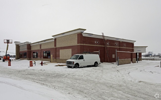
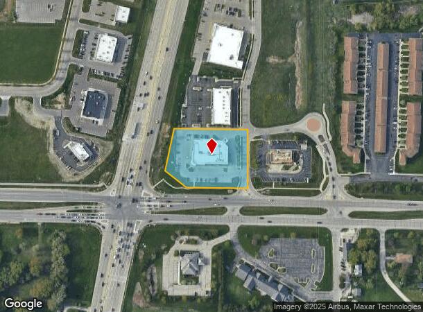
Property Record
3710 57Th Ave, Kenosha, WI 53144
NEARBY LISTINGS FOR SALE OR LEASE
Property Detail
3710 57Th Ave
Chicago-Naperville-Elgin, IL-IN-WI
Csm# 2675
08-222-27-101-012
LOT 2 CSM #2675 DOC#1628568 A RE-DIV PARCEL 2 CSM #2330 PT NE 1/4 SEC 27 T 2 R 22 AFF CORRECTION DOC#1646970 (2003 PT 08-222-
Commercialnec
Kenosha
X
Wisconsin
55059C0182D
2
2024
1.78 AC
2024
Kenosha East
000603
Chicago
13,833 SF
DEMOGRAPHICS near 3710 57Th Ave
1 Mile
3 Mile
5 Mile
2024 Total Population
4,967
64,526
115,138
2029 Population
4,932
63,841
114,097
Pop Growth 2024-2029
(0.70%)
(1.06%)
(0.90%)
Average Age
41
38
40
2024 Total Households
2,073
25,101
45,906
HH Growth 2024-2029
(0.68%)
(1.00%)
(0.90%)
Median Household Inc
$81,885
$62,317
$66,808
Avg Household Size
2.30
2.40
2.40
2024 Avg HH Vehicles
2.00
2.00
2.00
Median Home Value
$250,943
$189,721
$212,883
Median Year Built
1998
1968
1972
Nearby Places
Map Layers
Map Styles
 Street
 Aerial
- Restaurants
- Banks
- Shops
- Fitness
- Groceries
PUBLIC TRANSPORTATION
COMMUTER RAIL
Kenosha Station (Union Pacific North Line - Northeast Illinois Regional Commuter Railroad (Metra))
DRIVE
WALK
Distance
Kenosha Station (Union Pacific North Line - Northeast Illinois Regional Commuter Railroad (Metra))
9 min
3.9 mi
AIRPORT
General Mitchell International
DRIVE
WALK
Distance
General Mitchell International
37 min
28.9 mi
Freight Ports
Port Milwaukee
DRIVE
WALK
Distance
Port Milwaukee
41 min
32.7 mi
Nearby Properties
Address
Land Use
TOTAL SIZE
Lot Size
Zoning
Address
Land Use
TOTAL SIZE
Lot Size
Zoning
731,186 SF
81.94 AC
M2
Address
Land Use
TOTAL SIZE
Lot Size
Zoning
3,886 SF
20.04 AC
Address
Land Use
TOTAL SIZE
Lot Size
Zoning
57.67 AC
Address
Land Use
TOTAL SIZE
Lot Size
Zoning
773 SF
21.36 AC
Address
Land Use
TOTAL SIZE
Lot Size
Zoning
606,510 SF
36.02 AC
Address
Land Use
TOTAL SIZE
Lot Size
Zoning
606,510 SF
32.10 AC
Address
Land Use
TOTAL SIZE
Lot Size
Zoning
30.04 AC
Address
Land Use
TOTAL SIZE
Lot Size
Zoning
850,230 SF
39.46 AC
M2
Address
Land Use
TOTAL SIZE
Lot Size
Zoning
35,092 SF
26.34 AC
B2
Address
Land Use
TOTAL SIZE
Lot Size
Zoning
183,173 SF
9.73 AC
RM3
Address
Land Use
TOTAL SIZE
Lot Size
Zoning
16,466 SF
19.09 AC
RM2
Address
Land Use
TOTAL SIZE
Lot Size
Zoning
32,245 SF
22 AC
RM2
Address
Land Use
TOTAL SIZE
Lot Size
Zoning
21,072 SF
24.33 AC
RM2
Address
Land Use
TOTAL SIZE
Lot Size
Zoning
26,016 SF
14.02 AC
FW
Address
Land Use
TOTAL SIZE
Lot Size
Zoning
194,281 SF
19.13 AC
B2
Address
Land Use
TOTAL SIZE
Lot Size
Zoning
25.40 AC
FW
Address
Land Use
TOTAL SIZE
Lot Size
Zoning
14.60 AC
Address
Land Use
TOTAL SIZE
Lot Size
Zoning
26,500 SF
17.79 AC
RM2
Address
Land Use
TOTAL SIZE
Lot Size
Zoning
85,469 SF
11.30 AC
Address
Land Use
TOTAL SIZE
Lot Size
Zoning
176,978 SF
24.81 AC
Address
Land Use
TOTAL SIZE
Lot Size
Zoning
5.03 AC
RM2
Address
Land Use
TOTAL SIZE
Lot Size
Zoning
172,962 SF
9.23 AC
M2
Address
Land Use
TOTAL SIZE
Lot Size
Zoning
88,473 SF
8.98 AC
B2
Address
Land Use
TOTAL SIZE
Lot Size
Zoning
17.03 AC
M2
Address
Land Use
TOTAL SIZE
Lot Size
Zoning
6.61 AC
Address
Land Use
TOTAL SIZE
Lot Size
Zoning
161,640 SF
14.88 AC
B2
Address
Land Use
TOTAL SIZE
Lot Size
Zoning
25,775 SF
3.43 AC
Address
Land Use
TOTAL SIZE
Lot Size
Zoning
134,270 SF
17.17 AC
Address
Land Use
TOTAL SIZE
Lot Size
Zoning
13.66 AC
M2
Address
Land Use
TOTAL SIZE
Lot Size
Zoning
12.38 AC
M1
The World's #1 Commercial Real Estate Marketplace
Connect with us
© 2025 CoStar Group
The information above has been obtained from sources believed reliable. While we do not doubt its accuracy we have not verified it and make no guarantee, warranty or representation about it. It is your responsibility to independently confirm its accuracy and completeness. Any projections, opinions, assumptions, or estimates used are for example only and do not represent the current or future performance of the property. The value of this transaction to you depends on tax and other factors which should be evaluated by your tax, financial, and legal advisors. You and your advisors should conduct a careful, independent investigation of the property to determine to your satisfaction the suitability of the property for your needs.