Property Record
3711 S Council Spring Rd, Boise, ID 83716
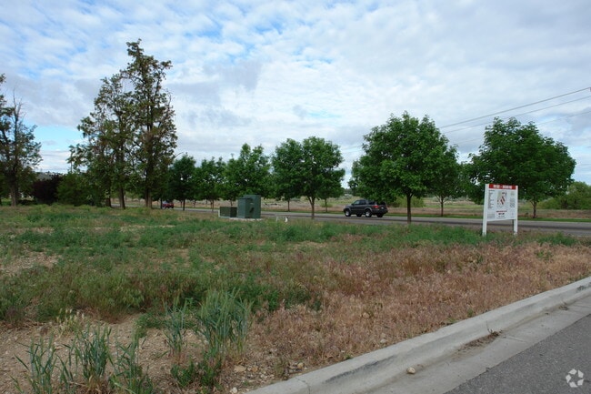

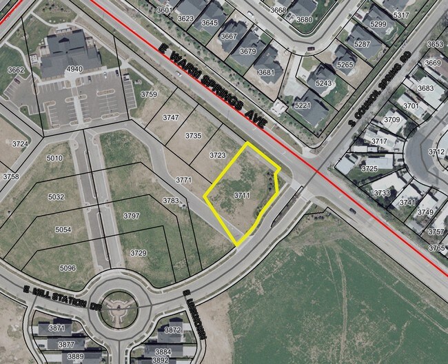
Property Detail
3711 S Council Spring Rd
R3482200090
LOT 10 BLK 05 HARRIS RANCH SUB NO 06
Commercialbuilding
Ada
SP-01
Idaho
B and X Area of moderate flood hazard, usually the area between the limits of the 100-year and 500-year floods.
10
2024
0.49 AC
2025
Southeast Boise
010101
Boise City/Nampa
13,071 SF
Boise City, ID
NEARBY LISTINGS FOR SALE OR LEASE
DEMOGRAPHICS near 3711 S Council Spring Rd
1 mile
3 mile
5 mile
2025 Total Population
6,542
31,256
66,199
2030 Population
6,927
32,758
69,585
Pop Growth 2025-2030
+ 5.89%
+ 4.81%
+ 5.11%
Average Age
42
42
40
2025 Total Households
2,450
12,090
28,160
HH Growth 2025-2030
+ 6.37%
+ 5.19%
+ 5.64%
Median Household Inc
$170,085
$133,688
$99,660
Avg Household Size
2.60
2.50
2.20
2025 Avg HH Vehicles
2.00
2.00
2.00
Median Home Value
$777,181
$663,523
$634,953
Median Year Built
2010
1997
1992
Nearby Places
Map Layers
Map Styles
 Street
 Aerial
Layers
 Traffic
 Biking
Places
Listings with unknown addresses are not visible on the map
- Restaurants
- Banks
- Shops
- Fitness
- Groceries
PUBLIC TRANSPORTATION
AIRPORT
Boise Air Trml/Gowen Field
Drive
Walk
Distance
Boise Air Trml/Gowen Field
18 min
8.8 mi
Nearby Properties
Address
Land Use
TOTAL SIZE
Lot Size
Zoning
Address
Land Use
TOTAL SIZE
Lot Size
Zoning
122,110 SF
12.66 AC
T-2D/DA
Address
Land Use
TOTAL SIZE
Lot Size
Zoning
347,991 SF
12.51 AC
SP-02
Address
Land Use
TOTAL SIZE
Lot Size
Zoning
245,240 SF
5.40 AC
R-2D
Address
Land Use
TOTAL SIZE
Lot Size
Zoning
259,565 SF
4.07 AC
SP-02
Address
Land Use
TOTAL SIZE
Lot Size
Zoning
215,141 SF
5.25 AC
SP-01
Address
Land Use
TOTAL SIZE
Lot Size
Zoning
366,032 SF
10.79 AC
C-4D
Address
Land Use
TOTAL SIZE
Lot Size
Zoning
190,180 SF
14.43 AC
R-2D
Address
Land Use
TOTAL SIZE
Lot Size
Zoning
237,299 SF
20.32 AC
M-1D
Address
Land Use
TOTAL SIZE
Lot Size
Zoning
50,674 SF
49.82 AC
T-2D
Address
Land Use
TOTAL SIZE
Lot Size
Zoning
150,147 SF
3.94 AC
SP-01
Address
Land Use
TOTAL SIZE
Lot Size
Zoning
3.41 AC
SP-02
Address
Land Use
TOTAL SIZE
Lot Size
Zoning
0.82 AC
SP-02
Address
Land Use
TOTAL SIZE
Lot Size
Zoning
66.20 AC
T-2D
Address
Land Use
TOTAL SIZE
Lot Size
Zoning
174,354 SF
16.15 AC
M-1D
Address
Land Use
TOTAL SIZE
Lot Size
Zoning
225,127 SF
20.62 AC
M-1D
Address
Land Use
TOTAL SIZE
Lot Size
Zoning
123,214 SF
7.54 AC
M-2D
Address
Land Use
TOTAL SIZE
Lot Size
Zoning
73,415 SF
4.63 AC
SP-02
Address
Land Use
TOTAL SIZE
Lot Size
Zoning
90,300 SF
32.64 AC
M-1D
Address
Land Use
TOTAL SIZE
Lot Size
Zoning
99,085 SF
8.25 AC
C-1D
Address
Land Use
TOTAL SIZE
Lot Size
Zoning
69,464 SF
12.23 AC
C-4D
Address
Land Use
TOTAL SIZE
Lot Size
Zoning
129,424 SF
7.97 AC
M-1D
Address
Land Use
TOTAL SIZE
Lot Size
Zoning
222,526 SF
36.74 AC
ZC-269
Address
Land Use
TOTAL SIZE
Lot Size
Zoning
89,996 SF
5.43 AC
M-1D
Address
Land Use
TOTAL SIZE
Lot Size
Zoning
48,135 SF
4.04 AC
L-OD/DA
Address
Land Use
TOTAL SIZE
Lot Size
Zoning
74,639 SF
6.75 AC
M-2D
Address
Land Use
TOTAL SIZE
Lot Size
Zoning
107,806 SF
7.45 AC
C-2
Address
Land Use
TOTAL SIZE
Lot Size
Zoning
124,980 SF
13.19 AC
M-1D
Address
Land Use
TOTAL SIZE
Lot Size
Zoning
47,379 SF
2.69 AC
SP-01
Address
Land Use
TOTAL SIZE
Lot Size
Zoning
51,840 SF
6.17 AC
M-1D
Address
Land Use
TOTAL SIZE
Lot Size
Zoning
67,888 SF
6.09 AC
R-2D
The World's #1 Commercial Real Estate Marketplace
Connect with us
© 2026 CoStar Group
The information above has been obtained from sources believed reliable. While we do not doubt its accuracy we have not verified it and make no guarantee, warranty or representation about it. It is your responsibility to independently confirm its accuracy and completeness. Any projections, opinions, assumptions, or estimates used are for example only and do not represent the current or future performance of the property. The value of this transaction to you depends on tax and other factors which should be evaluated by your tax, financial, and legal advisors. You and your advisors should conduct a careful, independent investigation of the property to determine to your satisfaction the suitability of the property for your needs.