Property Record
3712 Apex Hwy, Durham, NC 27713
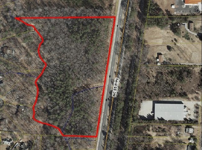

Property Detail
3712 Apex Hwy
Durham-Chapel Hill, NC
PROP-FRANK SHIP/LT#1 PL:26-105
157220
DURHAM
Commercialacreage
North Carolina
RS-20
1
AE The base floodplain where base flood elevations are provided. AE Zones are now used on new format FIRMs instead of A1-A30 Zones.
9.79 AC
2025
Research Triangle
2025
Raleigh/Durham
002022
NEARBY LISTINGS FOR SALE OR LEASE
DEMOGRAPHICS near 3712 Apex Hwy
1 mile
3 mile
5 mile
2025 Total Population
4,599
55,733
159,715
2030 Population
4,903
58,876
170,087
Pop Growth 2025-2030
+ 6.61%
+ 5.64%
+ 6.49%
Average Age
38
38
38
2025 Total Households
2,030
24,956
67,802
HH Growth 2025-2030
+ 6.75%
+ 5.86%
+ 6.74%
Median Household Inc
$73,399
$89,991
$93,291
Avg Household Size
2.20
2.20
2.30
2025 Avg HH Vehicles
2.00
2.00
2.00
Median Home Value
$395,993
$405,690
$439,282
Median Year Built
1995
1998
1999
Nearby Places
Map Layers
Map Styles
 Street
 Aerial
Layers
 Traffic
 Biking
Places
Listings with unknown addresses are not visible on the map
- Restaurants
- Banks
- Shops
- Fitness
- Groceries
PUBLIC TRANSPORTATION
COMMUTER RAIL
Durham Amtrak Station (Carolinian - Amtrak, Piedmont - Amtrak)
Drive
Walk
Distance
Durham Amtrak Station (Carolinian - Amtrak, Piedmont - Amtrak)
13 min
6.9 mi
AIRPORT
Raleigh-Durham International
Drive
Walk
Distance
Raleigh-Durham International
14 min
9.0 mi
Freight Ports
Port of Wilmington
Drive
Walk
Distance
Port of Wilmington
174 min
153.1 mi
SALE & LEASE HISTORY
LISTING DATE
SALE/LEASE

Jun 18, 2018
For Lease
Jan 19, 2017
For Sale
Nearby Properties
Address
Land Use
TOTAL SIZE
Lot Size
Zoning
Address
Land Use
TOTAL SIZE
Lot Size
Zoning
2,436,024 SF
SRP
Address
Land Use
TOTAL SIZE
Lot Size
Zoning
875,384 SF
111.74 AC
SRP
Address
Land Use
TOTAL SIZE
Lot Size
Zoning
1,080,486 SF
61.68 AC
SRP
Address
Land Use
TOTAL SIZE
Lot Size
Zoning
677,504 SF
60.32 AC
SRP
Address
Land Use
TOTAL SIZE
Lot Size
Zoning
29.13 AC
CG(D)
Address
Land Use
TOTAL SIZE
Lot Size
Zoning
1,272,163 SF
117.61 AC
OI,SRP
Address
Land Use
TOTAL SIZE
Lot Size
Zoning
1,378,965 SF
183.46 AC
SRP
Address
Land Use
TOTAL SIZE
Lot Size
Zoning
868,283 SF
56.23 AC
SRP
Address
Land Use
TOTAL SIZE
Lot Size
Zoning
491,701 SF
124.48 AC
SRP
Address
Land Use
TOTAL SIZE
Lot Size
Zoning
799,818 SF
84.58 AC
IL
Address
Land Use
TOTAL SIZE
Lot Size
Zoning
444,254 SF
58.71 AC
SRP
Address
Land Use
TOTAL SIZE
Lot Size
Zoning
35.03 AC
RS-M(D)
Address
Land Use
TOTAL SIZE
Lot Size
Zoning
2,922 SF
30.57 AC
PDR 4.840
Address
Land Use
TOTAL SIZE
Lot Size
Zoning
319,275 SF
50.52 AC
SRP
Address
Land Use
TOTAL SIZE
Lot Size
Zoning
353,339 SF
25.95 AC
SRP
Address
Land Use
TOTAL SIZE
Lot Size
Zoning
2.82 AC
SRP-C
Address
Land Use
TOTAL SIZE
Lot Size
Zoning
23,889 SF
50.95 AC
OI
Address
Land Use
TOTAL SIZE
Lot Size
Zoning
7,080 SF
30.67 AC
OI,RS-M
Address
Land Use
TOTAL SIZE
Lot Size
Zoning
6,948 SF
21.22 AC
RS-M(D)
Address
Land Use
TOTAL SIZE
Lot Size
Zoning
10,143 SF
46.78 AC
PDR 5.940
Address
Land Use
TOTAL SIZE
Lot Size
Zoning
7,241 SF
25.34 AC
PDR 5.370
Address
Land Use
TOTAL SIZE
Lot Size
Zoning
8,199 SF
28.28 AC
PDR 12.000
Address
Land Use
TOTAL SIZE
Lot Size
Zoning
555,485 SF
34.84 AC
SRP
Address
Land Use
TOTAL SIZE
Lot Size
Zoning
6,180 SF
26.56 AC
RS-M(D)
Address
Land Use
TOTAL SIZE
Lot Size
Zoning
4,744 SF
12.90 AC
MU(D)
Address
Land Use
TOTAL SIZE
Lot Size
Zoning
9,816 SF
26.57 AC
RS-M
Address
Land Use
TOTAL SIZE
Lot Size
Zoning
10,572 SF
27.56 AC
RS-M(D)
Address
Land Use
TOTAL SIZE
Lot Size
Zoning
5,184 SF
42.28 AC
OI(D)
Address
Land Use
TOTAL SIZE
Lot Size
Zoning
12,864 SF
24.27 AC
RS-M
Address
Land Use
TOTAL SIZE
Lot Size
Zoning
240,537 SF
43.98 AC
IL
The World's #1 Commercial Real Estate Marketplace
Connect with us
© 2026 CoStar Group
The information above has been obtained from sources believed reliable. While we do not doubt its accuracy we have not verified it and make no guarantee, warranty or representation about it. It is your responsibility to independently confirm its accuracy and completeness. Any projections, opinions, assumptions, or estimates used are for example only and do not represent the current or future performance of the property. The value of this transaction to you depends on tax and other factors which should be evaluated by your tax, financial, and legal advisors. You and your advisors should conduct a careful, independent investigation of the property to determine to your satisfaction the suitability of the property for your needs.