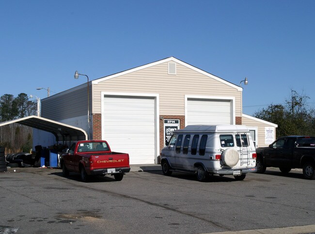
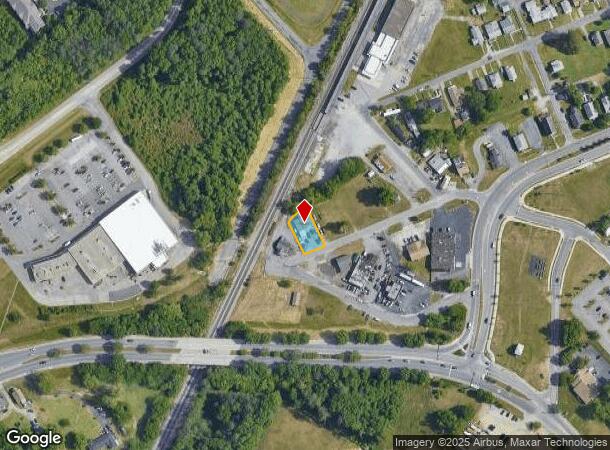
Property Record
3714 E River Rd, South Chesterfield, VA 23803
NEARBY LISTINGS FOR SALE OR LEASE
Property Detail
3714 E River Rd
794-61-24-98-000-000
Laurel Branch Farm 68
Autorepair
LAUREL BRANCH FARM 68.
X
Chesterfield
51041C0435E
Virginia
2025
0.24 AC
2025
Colonial Heights
100600
Richmond VA
2,016 SF
Richmond, VA
DEMOGRAPHICS near 3714 E River Rd
1 Mile
3 Mile
5 Mile
2024 Total Population
7,980
48,403
83,956
2029 Population
8,469
49,785
85,917
Pop Growth 2024-2029
+ 6.13%
+ 2.86%
+ 2.34%
Average Age
32
39
39
2024 Total Households
1,920
19,637
31,936
HH Growth 2024-2029
+ 8.07%
+ 2.70%
+ 2.21%
Median Household Inc
$54,311
$48,617
$54,019
Avg Household Size
2.50
2.20
2.30
2024 Avg HH Vehicles
2.00
2.00
2.00
Median Home Value
$204,558
$168,170
$182,503
Median Year Built
1967
1967
1971
Nearby Places
Map Layers
Map Styles
 Street
 Aerial
- Restaurants
- Banks
- Shops
- Fitness
- Groceries
PUBLIC TRANSPORTATION
COMMUTER RAIL
DRIVE
WALK
Distance
1 min
3 min
0.2 mi
AIRPORT
Richmond International
DRIVE
WALK
Distance
Richmond International
41 min
27.2 mi
Freight Ports
Virginia Port Authority - Richmond
DRIVE
WALK
Distance
Virginia Port Authority - Richmond
30 min
19.6 mi
Nearby Properties
Address
Land Use
TOTAL SIZE
Lot Size
Zoning
Address
Land Use
TOTAL SIZE
Lot Size
Zoning
500 SF
390.12 AC
R7 - SINGL
Address
Land Use
TOTAL SIZE
Lot Size
Zoning
1,232 SF
571 AC
R1
Address
Land Use
TOTAL SIZE
Lot Size
Zoning
165,942 SF
0.57 AC
R7 - SINGL
Address
Land Use
TOTAL SIZE
Lot Size
Zoning
51,588 SF
13.86 AC
RMF - RES,
Address
Land Use
TOTAL SIZE
Lot Size
Zoning
94,876 SF
28.84 AC
A - AGRICU
Address
Land Use
TOTAL SIZE
Lot Size
Zoning
209,515 SF
21.20 AC
B3
Address
Land Use
TOTAL SIZE
Lot Size
Zoning
95,944 SF
15.75 AC
C2 - NBHD
Address
Land Use
TOTAL SIZE
Lot Size
Zoning
188,368 SF
18.96 AC
B1
Address
Land Use
TOTAL SIZE
Lot Size
Zoning
128,796 SF
75.49 AC
A - AGRICU
Address
Land Use
TOTAL SIZE
Lot Size
Zoning
119,151 SF
3.10 AC
M-1
Address
Land Use
TOTAL SIZE
Lot Size
Zoning
130,698 SF
10.78 AC
PUD
Address
Land Use
TOTAL SIZE
Lot Size
Zoning
223,211 SF
19.99 AC
B3
Address
Land Use
TOTAL SIZE
Lot Size
Zoning
57,011 SF
4.45 AC
BB
Address
Land Use
TOTAL SIZE
Lot Size
Zoning
140,000 SF
1 AC
999
Address
Land Use
TOTAL SIZE
Lot Size
Zoning
14.57 AC
R-4
Address
Land Use
TOTAL SIZE
Lot Size
Zoning
173,829 SF
13.73 AC
B2
Address
Land Use
TOTAL SIZE
Lot Size
Zoning
129,600 SF
12.21 AC
PUD
Address
Land Use
TOTAL SIZE
Lot Size
Zoning
100 SF
12.39 AC
R7 - SINGL
Address
Land Use
TOTAL SIZE
Lot Size
Zoning
128,848 SF
13.24 AC
B3
Address
Land Use
TOTAL SIZE
Lot Size
Zoning
92,701 SF
2.87 AC
B1
Address
Land Use
TOTAL SIZE
Lot Size
Zoning
89,734 SF
2.85 AC
B1
Address
Land Use
TOTAL SIZE
Lot Size
Zoning
86,387 SF
10.91 AC
B3
Address
Land Use
TOTAL SIZE
Lot Size
Zoning
185,483 SF
20.98 AC
R-4
Address
Land Use
TOTAL SIZE
Lot Size
Zoning
26.67 AC
R-4
Address
Land Use
TOTAL SIZE
Lot Size
Zoning
3,632 SF
11.30 AC
M-2
Address
Land Use
TOTAL SIZE
Lot Size
Zoning
37,809 SF
150 AC
R7 - SINGL
Address
Land Use
TOTAL SIZE
Lot Size
Zoning
68,438 SF
1.93 AC
Address
Land Use
TOTAL SIZE
Lot Size
Zoning
140,340 SF
13.08 AC
B3
Address
Land Use
TOTAL SIZE
Lot Size
Zoning
182,760 SF
10.50 AC
R-4
Address
Land Use
TOTAL SIZE
Lot Size
Zoning
116,795 SF
10.78 AC
B3
The World's #1 Commercial Real Estate Marketplace
Connect with us
© 2025 CoStar Group
The information above has been obtained from sources believed reliable. While we do not doubt its accuracy we have not verified it and make no guarantee, warranty or representation about it. It is your responsibility to independently confirm its accuracy and completeness. Any projections, opinions, assumptions, or estimates used are for example only and do not represent the current or future performance of the property. The value of this transaction to you depends on tax and other factors which should be evaluated by your tax, financial, and legal advisors. You and your advisors should conduct a careful, independent investigation of the property to determine to your satisfaction the suitability of the property for your needs.