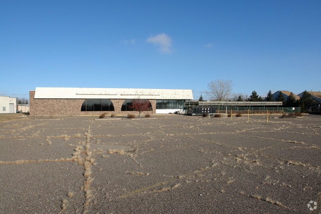
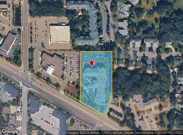
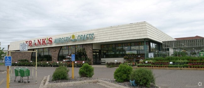
Property Record
3715 Coon Rapids Blvd Nw, Minneapolis, MN 55433
NEARBY LISTINGS FOR SALE OR LEASE
Property Detail
3715 Coon Rapids Blvd Nw
Minneapolis-St. Paul-Bloomington, MN-WI
Reisling Park North 4Th Add
17-31-24-21-0019
LOT 5 BLK 1 REISLING PARK N 4TH ADD SUBJ TO EASE OF REC
Apartment
Anoka
X
Minnesota
27053C0086F
5
2024
3.49 AC
2025
Coon Rapids
050611
Minneapolis/St Paul
91,581 SF
DEMOGRAPHICS near 3715 Coon Rapids Blvd Nw
1 Mile
3 Mile
5 Mile
2024 Total Population
11,516
79,889
175,052
2029 Population
11,796
81,220
178,150
Pop Growth 2024-2029
+ 2.43%
+ 1.67%
+ 1.77%
Average Age
41
40
40
2024 Total Households
4,575
30,916
64,540
HH Growth 2024-2029
+ 2.56%
+ 1.85%
+ 1.85%
Median Household Inc
$76,969
$82,601
$90,996
Avg Household Size
2.50
2.50
2.60
2024 Avg HH Vehicles
2.00
2.00
2.00
Median Home Value
$273,108
$279,194
$290,543
Median Year Built
1982
1983
1986
Nearby Places
Map Layers
Map Styles
 Street
 Aerial
- Restaurants
- Banks
- Shops
- Fitness
- Groceries
PUBLIC TRANSPORTATION
COMMUTER RAIL
Coon Rapids-Riverdale Station (Northstar Corridor - Northstar Commuter Rail)
DRIVE
WALK
Distance
Coon Rapids-Riverdale Station (Northstar Corridor - Northstar Commuter Rail)
5 min
1.9 mi
Anoka Station (Northstar Corridor - Northstar Commuter Rail)
DRIVE
WALK
Distance
Anoka Station (Northstar Corridor - Northstar Commuter Rail)
7 min
2.9 mi
AIRPORT
Minneapolis-St Paul International/Wold-Chamberlain
DRIVE
WALK
Distance
Minneapolis-St Paul International/Wold-Chamberlain
47 min
28.7 mi
Freight Ports
Port Milwaukee
DRIVE
WALK
Distance
Port Milwaukee
393 min
354.5 mi
Nearby Properties
Address
Land Use
TOTAL SIZE
Lot Size
Zoning
Address
Land Use
TOTAL SIZE
Lot Size
Zoning
517,619 SF
3.85 AC
Address
Land Use
TOTAL SIZE
Lot Size
Zoning
468,099 SF
5.73 AC
MSMU
Address
Land Use
TOTAL SIZE
Lot Size
Zoning
412,914 SF
40 AC
Address
Land Use
TOTAL SIZE
Lot Size
Zoning
3.80 AC
Address
Land Use
TOTAL SIZE
Lot Size
Zoning
319,826 SF
37.97 AC
Address
Land Use
TOTAL SIZE
Lot Size
Zoning
2,400 SF
72.45 AC
Address
Land Use
TOTAL SIZE
Lot Size
Zoning
5,110 SF
38.62 AC
Address
Land Use
TOTAL SIZE
Lot Size
Zoning
Address
Land Use
TOTAL SIZE
Lot Size
Zoning
122,816 SF
27.84 AC
Address
Land Use
TOTAL SIZE
Lot Size
Zoning
4.99 AC
Address
Land Use
TOTAL SIZE
Lot Size
Zoning
Address
Land Use
TOTAL SIZE
Lot Size
Zoning
129,060 SF
10.21 AC
Address
Land Use
TOTAL SIZE
Lot Size
Zoning
167 SF
4.73 AC
Address
Land Use
TOTAL SIZE
Lot Size
Zoning
Address
Land Use
TOTAL SIZE
Lot Size
Zoning
Address
Land Use
TOTAL SIZE
Lot Size
Zoning
13.44 AC
Address
Land Use
TOTAL SIZE
Lot Size
Zoning
159,335 SF
13.64 AC
Address
Land Use
TOTAL SIZE
Lot Size
Zoning
168,887 SF
7.01 AC
Address
Land Use
TOTAL SIZE
Lot Size
Zoning
148 SF
39.49 AC
Address
Land Use
TOTAL SIZE
Lot Size
Zoning
14.27 AC
Address
Land Use
TOTAL SIZE
Lot Size
Zoning
114,281 SF
3.19 AC
PRD-4
Address
Land Use
TOTAL SIZE
Lot Size
Zoning
11.55 AC
Address
Land Use
TOTAL SIZE
Lot Size
Zoning
Address
Land Use
TOTAL SIZE
Lot Size
Zoning
118,208 SF
Address
Land Use
TOTAL SIZE
Lot Size
Zoning
Address
Land Use
TOTAL SIZE
Lot Size
Zoning
Address
Land Use
TOTAL SIZE
Lot Size
Zoning
151,862 SF
12.97 AC
Address
Land Use
TOTAL SIZE
Lot Size
Zoning
155,849 SF
0.83 AC
Address
Land Use
TOTAL SIZE
Lot Size
Zoning
137 SF
8.50 AC
Address
Land Use
TOTAL SIZE
Lot Size
Zoning
811,860 SF
The World's #1 Commercial Real Estate Marketplace
Connect with us
© 2026 CoStar Group
The information above has been obtained from sources believed reliable. While we do not doubt its accuracy we have not verified it and make no guarantee, warranty or representation about it. It is your responsibility to independently confirm its accuracy and completeness. Any projections, opinions, assumptions, or estimates used are for example only and do not represent the current or future performance of the property. The value of this transaction to you depends on tax and other factors which should be evaluated by your tax, financial, and legal advisors. You and your advisors should conduct a careful, independent investigation of the property to determine to your satisfaction the suitability of the property for your needs.