Property Record
3716 12Th Ave E, Tuscaloosa, AL 35405
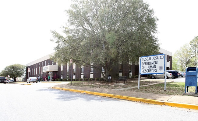

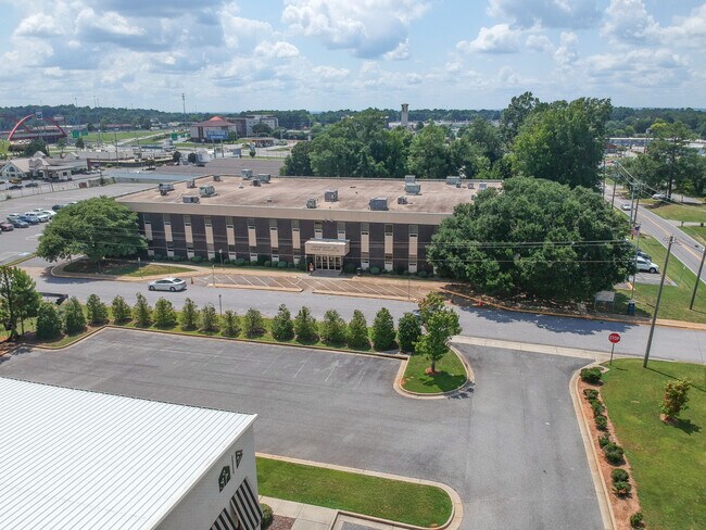
This Property Is For Sale
NEARBY LISTINGS FOR SALE OR LEASE
Property Detail
3716 12Th Ave E
30-09-31-3-001-001.001
COM AT INT OF S LINE OF 37TH ST E & E LINE OF MCFARLAND BLVD IN SW 1/4 OF S-31 T-21 R-9. TH E ALG 37TH ST E 456.9' TO POB, CONT E 200', SE'LY 512'S, NW 349.8', NE'LY 200', NW'LY 98.5', E 138.3', NW 180' S TO POB
Officebuilding
Tuscaloosa
X
Alabama
01125C0517G
3.40 AC
2025
Tuscaloosa
2024
Birmingham
012306
Tuscaloosa, AL
46,566 SF
DEMOGRAPHICS near 3716 12Th Ave E
1 Mile
3 Mile
5 Mile
2024 Total Population
8,977
70,422
138,874
2029 Population
10,204
80,116
156,768
Pop Growth 2024-2029
+ 13.67%
+ 13.77%
+ 12.89%
Average Age
34
33
34
2024 Total Households
4,151
29,063
53,886
HH Growth 2024-2029
+ 13.11%
+ 14.81%
+ 14.29%
Median Household Inc
$36,250
$39,103
$43,563
Avg Household Size
2.10
2.10
2.20
2024 Avg HH Vehicles
2.00
2.00
2.00
Median Home Value
$156,030
$179,860
$195,636
Median Year Built
1984
1993
1990
Nearby Places
Map Layers
Map Styles
 Street
 Aerial
- Restaurants
- Banks
- Shops
- Fitness
- Groceries
PUBLIC TRANSPORTATION
COMMUTER RAIL
Tuscaloosa Amtrak Station (Crescent - Amtrak)
DRIVE
WALK
Distance
Tuscaloosa Amtrak Station (Crescent - Amtrak)
6 min
3.1 mi
Freight Ports
Port of Mobile
DRIVE
WALK
Distance
Port of Mobile
238 min
199.5 mi
Nearby Properties
Address
Land Use
TOTAL SIZE
Lot Size
Zoning
Address
Land Use
TOTAL SIZE
Lot Size
Zoning
318,383 SF
44 SF
BN
Address
Land Use
TOTAL SIZE
Lot Size
Zoning
22,925 SF
13.45 AC
R4
Address
Land Use
TOTAL SIZE
Lot Size
Zoning
11,278 SF
145 AC
R3
Address
Land Use
TOTAL SIZE
Lot Size
Zoning
9,258 SF
19 AC
R4
Address
Land Use
TOTAL SIZE
Lot Size
Zoning
252,793 SF
2.73 AC
BN
Address
Land Use
TOTAL SIZE
Lot Size
Zoning
279,917 SF
4.01 AC
MX3
Address
Land Use
TOTAL SIZE
Lot Size
Zoning
24,165 SF
28 AC
BN
Address
Land Use
TOTAL SIZE
Lot Size
Zoning
8,760 SF
23 AC
R4
Address
Land Use
TOTAL SIZE
Lot Size
Zoning
40,160 SF
10.79 AC
RMF1
Address
Land Use
TOTAL SIZE
Lot Size
Zoning
25,920 SF
16 AC
RMF1
Address
Land Use
TOTAL SIZE
Lot Size
Zoning
6,579 SF
15.07 AC
RMF1
Address
Land Use
TOTAL SIZE
Lot Size
Zoning
231,339 SF
4.20 AC
MX5
Address
Land Use
TOTAL SIZE
Lot Size
Zoning
160,989 SF
1.53 AC
RMF2
Address
Land Use
TOTAL SIZE
Lot Size
Zoning
55.11 AC
I
Address
Land Use
TOTAL SIZE
Lot Size
Zoning
15,888 SF
112 AC
I
Address
Land Use
TOTAL SIZE
Lot Size
Zoning
200,388 SF
1.22 AC
Address
Land Use
TOTAL SIZE
Lot Size
Zoning
11,804 SF
76 AC
Address
Land Use
TOTAL SIZE
Lot Size
Zoning
21,811 SF
16 AC
R4
Address
Land Use
TOTAL SIZE
Lot Size
Zoning
110,337 SF
0.91 AC
RMF2
Address
Land Use
TOTAL SIZE
Lot Size
Zoning
5,377 SF
22 AC
RMF1
Address
Land Use
TOTAL SIZE
Lot Size
Zoning
196,378 SF
1.46 AC
MX5
Address
Land Use
TOTAL SIZE
Lot Size
Zoning
144,660 SF
1 AC
RMF2
Address
Land Use
TOTAL SIZE
Lot Size
Zoning
28,796 SF
15 AC
R4
Address
Land Use
TOTAL SIZE
Lot Size
Zoning
9,328 SF
19 AC
RMF1
Address
Land Use
TOTAL SIZE
Lot Size
Zoning
115,911 SF
4.48 AC
I
Address
Land Use
TOTAL SIZE
Lot Size
Zoning
1,088 SF
17 AC
R4
Address
Land Use
TOTAL SIZE
Lot Size
Zoning
12 AC
R1
Address
Land Use
TOTAL SIZE
Lot Size
Zoning
34 AC
R-3
Address
Land Use
TOTAL SIZE
Lot Size
Zoning
25,155 SF
6 AC
R4
Address
Land Use
TOTAL SIZE
Lot Size
Zoning
16,000 SF
12 AC
RMF1
The World's #1 Commercial Real Estate Marketplace
Connect with us
© 2026 CoStar Group
The information above has been obtained from sources believed reliable. While we do not doubt its accuracy we have not verified it and make no guarantee, warranty or representation about it. It is your responsibility to independently confirm its accuracy and completeness. Any projections, opinions, assumptions, or estimates used are for example only and do not represent the current or future performance of the property. The value of this transaction to you depends on tax and other factors which should be evaluated by your tax, financial, and legal advisors. You and your advisors should conduct a careful, independent investigation of the property to determine to your satisfaction the suitability of the property for your needs.