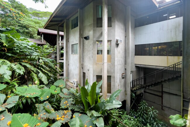
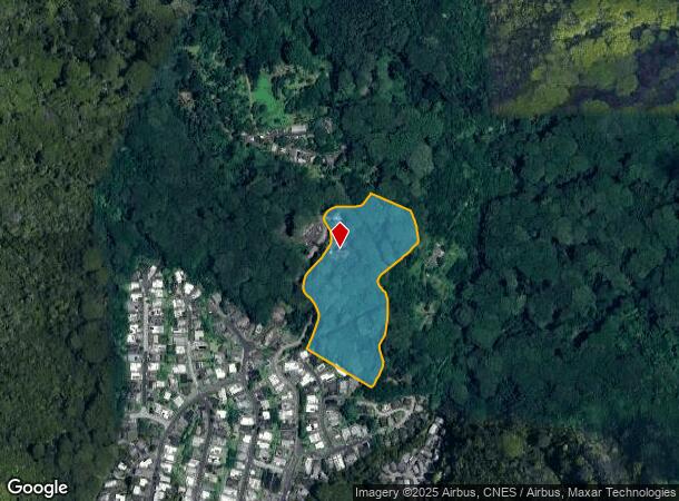
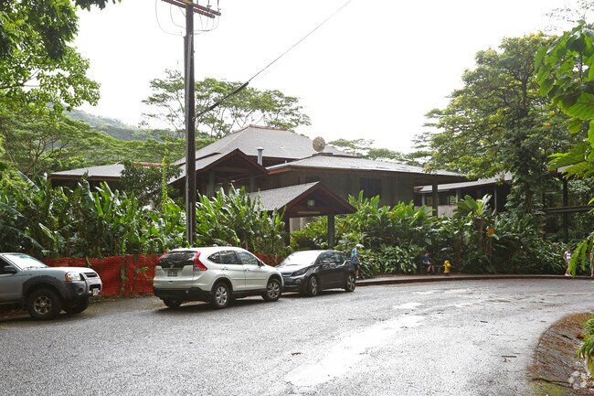
Property Record
3717 Manoa Rd, Honolulu, HI 96822
NEARBY LISTINGS FOR SALE OR LEASE
Property Detail
3717 Manoa Rd
1-2-9-054-018-0000
POR RPGR 204 KAMOAWAA,MANOA,HON,HI 12.3 AC DES *EXCL A STRIP OF LAND (40-FT WIDE) 1.3 AC **TMB NOTE: DOC NOTES AREA AS 77.58 AC. SAID AREA & DES IS
Commercialnec
Honolulu
X
Hawaii
15003C0360G
12.30 AC
2024
Honolulu
2025
Hawaii
003000
Urban Honolulu, HI
31,052 SF
DEMOGRAPHICS near 3717 Manoa Rd
1 Mile
3 Mile
5 Mile
2024 Total Population
4,098
66,108
345,121
2029 Population
3,908
64,100
340,250
Pop Growth 2024-2029
(4.64%)
(3.04%)
(1.41%)
Average Age
49
44
45
2024 Total Households
1,452
23,836
138,540
HH Growth 2024-2029
(5.65%)
(3.84%)
(1.34%)
Median Household Inc
$132,363
$97,599
$77,819
Avg Household Size
2.60
2.50
2.30
2024 Avg HH Vehicles
2.00
2.00
1.00
Median Home Value
$1,109,328
$1,029,623
$821,840
Median Year Built
1961
1965
1972
Nearby Places
Map Layers
Map Styles
 Street
 Aerial
- Restaurants
- Banks
- Shops
- Fitness
- Groceries
PUBLIC TRANSPORTATION
AIRPORT
Daniel K Inouye International
DRIVE
WALK
Distance
Daniel K Inouye International
24 min
10.5 mi
Freight Ports
Honolulu Harbor, Oahu
DRIVE
WALK
Distance
Honolulu Harbor, Oahu
26 min
10.4 mi
SALE & LEASE HISTORY
LISTING DATE
SALE/LEASE

Jun 09, 2019
For Lease
Nearby Properties
Address
Land Use
TOTAL SIZE
Lot Size
Zoning
Address
Land Use
TOTAL SIZE
Lot Size
Zoning
469,372 SF
3.52 AC
A-2
Address
Land Use
TOTAL SIZE
Lot Size
Zoning
46,449 SF
10.77 AC
R-7.5
Address
Land Use
TOTAL SIZE
Lot Size
Zoning
92,217 SF
5.77 AC
B-1
Address
Land Use
TOTAL SIZE
Lot Size
Zoning
3.54 AC
A-2
Address
Land Use
TOTAL SIZE
Lot Size
Zoning
61,968 SF
1.11 AC
A-2
Address
Land Use
TOTAL SIZE
Lot Size
Zoning
3.44 AC
P-2
Address
Land Use
TOTAL SIZE
Lot Size
Zoning
71,623 SF
0.99 AC
R-5
Address
Land Use
TOTAL SIZE
Lot Size
Zoning
89,550 SF
2.01 AC
B-2
Address
Land Use
TOTAL SIZE
Lot Size
Zoning
691.90 AC
P-1
Address
Land Use
TOTAL SIZE
Lot Size
Zoning
31,758 SF
2.05 AC
BMX-3
Address
Land Use
TOTAL SIZE
Lot Size
Zoning
144,114 SF
1.31 AC
R-5
Address
Land Use
TOTAL SIZE
Lot Size
Zoning
37,180 SF
2.11 AC
B-2
Address
Land Use
TOTAL SIZE
Lot Size
Zoning
29,645 SF
A-2
Address
Land Use
TOTAL SIZE
Lot Size
Zoning
65,830 SF
0.87 AC
B-2
Address
Land Use
TOTAL SIZE
Lot Size
Zoning
11,033 SF
1.72 AC
BMX-3
Address
Land Use
TOTAL SIZE
Lot Size
Zoning
73,595 SF
187.06 AC
P-2
Address
Land Use
TOTAL SIZE
Lot Size
Zoning
1.31 AC
R-5
Address
Land Use
TOTAL SIZE
Lot Size
Zoning
30,130 SF
2.99 AC
B-1
Address
Land Use
TOTAL SIZE
Lot Size
Zoning
14,453 SF
2.06 AC
R-7.5
Address
Land Use
TOTAL SIZE
Lot Size
Zoning
387 AC
P-1
Address
Land Use
TOTAL SIZE
Lot Size
Zoning
16,996 SF
1 AC
BMX-3
Address
Land Use
TOTAL SIZE
Lot Size
Zoning
14.01 AC
P-1
Address
Land Use
TOTAL SIZE
Lot Size
Zoning
14,135 SF
1.76 AC
R-7.5
Address
Land Use
TOTAL SIZE
Lot Size
Zoning
23,237 SF
3.43 AC
R-10
Address
Land Use
TOTAL SIZE
Lot Size
Zoning
1,052 SF
1.63 AC
R-7.5
Address
Land Use
TOTAL SIZE
Lot Size
Zoning
8,336 SF
1.97 AC
R-7.5
Address
Land Use
TOTAL SIZE
Lot Size
Zoning
413.01 AC
AG-2
Address
Land Use
TOTAL SIZE
Lot Size
Zoning
75,738 SF
0.27 AC
BMX-3
Address
Land Use
TOTAL SIZE
Lot Size
Zoning
7,428 SF
1.39 AC
R-7.5
Address
Land Use
TOTAL SIZE
Lot Size
Zoning
39,668 SF
1 AC
R-7.5
The World's #1 Commercial Real Estate Marketplace
Connect with us
© 2026 CoStar Group
The information above has been obtained from sources believed reliable. While we do not doubt its accuracy we have not verified it and make no guarantee, warranty or representation about it. It is your responsibility to independently confirm its accuracy and completeness. Any projections, opinions, assumptions, or estimates used are for example only and do not represent the current or future performance of the property. The value of this transaction to you depends on tax and other factors which should be evaluated by your tax, financial, and legal advisors. You and your advisors should conduct a careful, independent investigation of the property to determine to your satisfaction the suitability of the property for your needs.