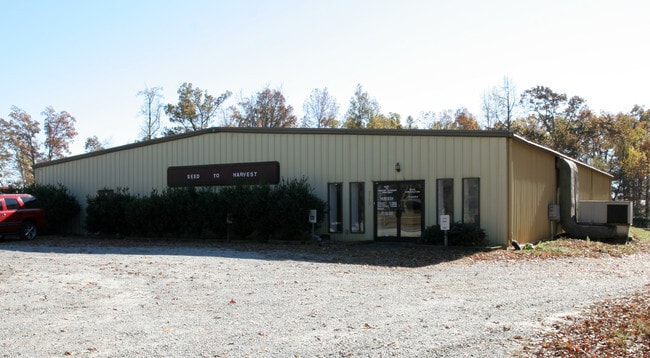
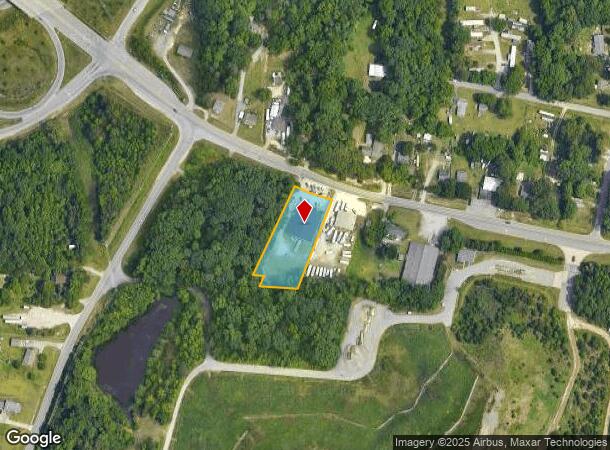
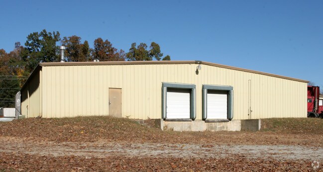
Property Record
3718 Kivett Dr, High Point, NC 27263
NEARBY LISTINGS FOR SALE OR LEASE
Property Detail
3718 Kivett Dr
Greensboro-High Point, NC
Mcdonald
0161059
.95AC LOT B PB72-301 MCDONALD PL:72-301
Industrialgeneral
Guilford
X
North Carolina
3710782000J
b
2024
0.95 AC
2025
High Point/SW Guilford Cty
016600
Greensboro/Winston-Salem
8,000 SF
DEMOGRAPHICS near 3718 Kivett Dr
1 Mile
3 Mile
5 Mile
2024 Total Population
2,511
25,609
90,654
2029 Population
2,482
25,633
91,294
Pop Growth 2024-2029
(1.15%)
+ 0.09%
+ 0.71%
Average Age
39
39
39
2024 Total Households
946
9,827
34,870
HH Growth 2024-2029
(1.16%)
+ 0.06%
+ 0.74%
Median Household Inc
$62,348
$50,062
$50,087
Avg Household Size
2.60
2.50
2.40
2024 Avg HH Vehicles
2.00
2.00
2.00
Median Home Value
$147,986
$139,917
$164,487
Median Year Built
1987
1974
1978
Nearby Places
Map Layers
Map Styles
 Street
 Aerial
- Restaurants
- Banks
- Shops
- Fitness
- Groceries
PUBLIC TRANSPORTATION
COMMUTER RAIL
High Point Station (Piedmont - North Carolina by Train (NC Train))
DRIVE
WALK
Distance
High Point Station (Piedmont - North Carolina by Train (NC Train))
8 min
4.5 mi
AIRPORT
Piedmont Triad International
DRIVE
WALK
Distance
Piedmont Triad International
26 min
14.0 mi
Freight Ports
Port of Wilmington
DRIVE
WALK
Distance
Port of Wilmington
250 min
212.1 mi
Nearby Properties
Address
Land Use
TOTAL SIZE
Lot Size
Zoning
Address
Land Use
TOTAL SIZE
Lot Size
Zoning
419,281 SF
25.12 AC
CIV
Address
Land Use
TOTAL SIZE
Lot Size
Zoning
805,958 SF
61.42 AC
LI
Address
Land Use
TOTAL SIZE
Lot Size
Zoning
1,259,149 SF
46.12 AC
HB
Address
Land Use
TOTAL SIZE
Lot Size
Zoning
30,322 SF
964.25 AC
PNR
Address
Land Use
TOTAL SIZE
Lot Size
Zoning
299,349 SF
21.76 AC
RM-16
Address
Land Use
TOTAL SIZE
Lot Size
Zoning
403,590 SF
72.06 AC
CIV
Address
Land Use
TOTAL SIZE
Lot Size
Zoning
324,986 SF
24.19 AC
LI
Address
Land Use
TOTAL SIZE
Lot Size
Zoning
473,040 SF
63.60 AC
AG
Address
Land Use
TOTAL SIZE
Lot Size
Zoning
72,851 SF
9.13 AC
IND
Address
Land Use
TOTAL SIZE
Lot Size
Zoning
113,866 SF
11.53 AC
LI
Address
Land Use
TOTAL SIZE
Lot Size
Zoning
159,944 SF
13.95 AC
RS-40
Address
Land Use
TOTAL SIZE
Lot Size
Zoning
79,740 SF
24.38 AC
R-5
Address
Land Use
TOTAL SIZE
Lot Size
Zoning
89,183 SF
17.12 AC
GB
Address
Land Use
TOTAL SIZE
Lot Size
Zoning
131,516 SF
10.78 AC
RM-16
Address
Land Use
TOTAL SIZE
Lot Size
Zoning
53,652 SF
7.84 AC
LI
Address
Land Use
TOTAL SIZE
Lot Size
Zoning
163,309 SF
36.05 AC
R-5
Address
Land Use
TOTAL SIZE
Lot Size
Zoning
63,326 SF
14.81 AC
CIV
Address
Land Use
TOTAL SIZE
Lot Size
Zoning
53,097 SF
6.36 AC
MS
Address
Land Use
TOTAL SIZE
Lot Size
Zoning
105,050 SF
9.58 AC
RM-16
Address
Land Use
TOTAL SIZE
Lot Size
Zoning
37,578 SF
36.11 AC
HI
Address
Land Use
TOTAL SIZE
Lot Size
Zoning
82,476 SF
5.37 AC
RM-8
Address
Land Use
TOTAL SIZE
Lot Size
Zoning
94,731 SF
14.69 AC
RM-16
Address
Land Use
TOTAL SIZE
Lot Size
Zoning
203,556 SF
18.40 AC
CZ-RM-16
Address
Land Use
TOTAL SIZE
Lot Size
Zoning
67,700 SF
10.75 AC
RM-16
Address
Land Use
TOTAL SIZE
Lot Size
Zoning
13,311 SF
162.92 AC
HI
Address
Land Use
TOTAL SIZE
Lot Size
Zoning
150.47 AC
PD-R
Address
Land Use
TOTAL SIZE
Lot Size
Zoning
65,733 SF
124.36 AC
HI
Address
Land Use
TOTAL SIZE
Lot Size
Zoning
51,175 SF
7.52 AC
CIV
Address
Land Use
TOTAL SIZE
Lot Size
Zoning
100,000 SF
10.06 AC
LI
Address
Land Use
TOTAL SIZE
Lot Size
Zoning
66,487 SF
10.16 AC
LI
The World's #1 Commercial Real Estate Marketplace
Connect with us
© 2026 CoStar Group
The information above has been obtained from sources believed reliable. While we do not doubt its accuracy we have not verified it and make no guarantee, warranty or representation about it. It is your responsibility to independently confirm its accuracy and completeness. Any projections, opinions, assumptions, or estimates used are for example only and do not represent the current or future performance of the property. The value of this transaction to you depends on tax and other factors which should be evaluated by your tax, financial, and legal advisors. You and your advisors should conduct a careful, independent investigation of the property to determine to your satisfaction the suitability of the property for your needs.