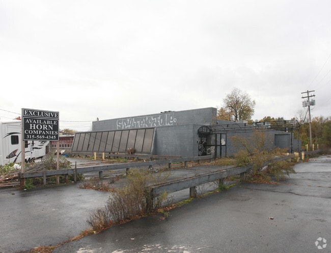
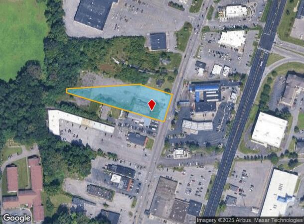
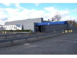
Property Record
3719 Brewerton Rd, Syracuse, NY 13212
NEARBY LISTINGS FOR SALE OR LEASE
Property Detail
3719 Brewerton Rd
314889-045-000-0005-003-001-0000
FL 3
Nightclub
Onondaga
X
New York
36067C0207F
3.001
2025
1.59 AC
2024
NE Outer Onondaga County
010800
Syracuse
8,104 SF
Syracuse, NY
DEMOGRAPHICS near 3719 Brewerton Rd
1 Mile
3 Mile
5 Mile
2024 Total Population
6,786
56,068
156,267
2029 Population
6,596
54,475
152,109
Pop Growth 2024-2029
(2.80%)
(2.84%)
(2.66%)
Average Age
45
43
40
2024 Total Households
3,213
24,656
68,459
HH Growth 2024-2029
(2.89%)
(3.00%)
(2.71%)
Median Household Inc
$63,676
$66,325
$58,410
Avg Household Size
2.00
2.20
2.20
2024 Avg HH Vehicles
2.00
2.00
1.00
Median Home Value
$143,934
$144,378
$148,980
Median Year Built
1957
1960
1959
Nearby Places
- Restaurants
- Banks
- Shops
- Fitness
- Groceries
PUBLIC TRANSPORTATION
COMMUTER RAIL
Syracuse Regional Transportation Center (Empire Service - Amtrak, Lake Shore Limited - Amtrak, Maple Leaf - Amtrak)
DRIVE
WALK
Distance
Syracuse Regional Transportation Center (Empire Service - Amtrak, Lake Shore Limited - Amtrak, Maple Leaf - Amtrak)
8 min
4.5 mi
Syracuse (Toronto - New York - VIA Rail)
DRIVE
WALK
Distance
Syracuse (Toronto - New York - VIA Rail)
8 min
4.5 mi
AIRPORT
Syracuse Hancock International
DRIVE
WALK
Distance
Syracuse Hancock International
5 min
1.9 mi
Freight Ports
Albany, NY Port
DRIVE
WALK
Distance
Albany, NY Port
173 min
145.7 mi
Nearby Properties
Address
Land Use
TOTAL SIZE
Lot Size
Zoning
Address
Land Use
TOTAL SIZE
Lot Size
Zoning
439,670 SF
74.73 AC
C-G
Address
Land Use
TOTAL SIZE
Lot Size
Zoning
169,752 SF
12.81 AC
04 - FARM
Address
Land Use
TOTAL SIZE
Lot Size
Zoning
432,246 SF
37.21 AC
05 - COMME
Address
Land Use
TOTAL SIZE
Lot Size
Zoning
22.16 AC
06 - INDUS
Address
Land Use
TOTAL SIZE
Lot Size
Zoning
11,484 SF
16.36 AC
03 - MULTI
Address
Land Use
TOTAL SIZE
Lot Size
Zoning
110,105 SF
26.68 AC
06 - INDUS
Address
Land Use
TOTAL SIZE
Lot Size
Zoning
218,439 SF
18.85 AC
Address
Land Use
TOTAL SIZE
Lot Size
Zoning
77,150 SF
159.25 AC
06 - INDUS
Address
Land Use
TOTAL SIZE
Lot Size
Zoning
2,025 SF
267.94 AC
06 - INDUS
Address
Land Use
TOTAL SIZE
Lot Size
Zoning
151,326 SF
9.23 AC
05 - COMME
Address
Land Use
TOTAL SIZE
Lot Size
Zoning
246,172 SF
16.65 AC
Address
Land Use
TOTAL SIZE
Lot Size
Zoning
3,968 SF
14.31 AC
03 - MULTI
Address
Land Use
TOTAL SIZE
Lot Size
Zoning
11,952 SF
9.14 AC
03 - MULTI
Address
Land Use
TOTAL SIZE
Lot Size
Zoning
38,000 SF
9.90 AC
22
Address
Land Use
TOTAL SIZE
Lot Size
Zoning
125,684 SF
25.61 AC
06 - INDUS
Address
Land Use
TOTAL SIZE
Lot Size
Zoning
3.59 AC
04 - FARM
Address
Land Use
TOTAL SIZE
Lot Size
Zoning
71,074 SF
27.78 AC
02 - SINGL
Address
Land Use
TOTAL SIZE
Lot Size
Zoning
78,656 SF
9.14 AC
06 - INDUS
Address
Land Use
TOTAL SIZE
Lot Size
Zoning
141,472 SF
12.38 AC
C-G
Address
Land Use
TOTAL SIZE
Lot Size
Zoning
92,844 SF
14.26 AC
C-G
Address
Land Use
TOTAL SIZE
Lot Size
Zoning
296.49 AC
06 - INDUS
Address
Land Use
TOTAL SIZE
Lot Size
Zoning
118,651 SF
12.27 AC
02 - SINGL
Address
Land Use
TOTAL SIZE
Lot Size
Zoning
17,240 SF
6.49 AC
03 - MULTI
Address
Land Use
TOTAL SIZE
Lot Size
Zoning
103,005 SF
12.58 AC
Address
Land Use
TOTAL SIZE
Lot Size
Zoning
27,044 SF
25.20 AC
C-G
Address
Land Use
TOTAL SIZE
Lot Size
Zoning
257,680 SF
10.22 AC
06 - INDUS
Address
Land Use
TOTAL SIZE
Lot Size
Zoning
63,140 SF
25.52 AC
Address
Land Use
TOTAL SIZE
Lot Size
Zoning
81,439 SF
15.48 AC
Address
Land Use
TOTAL SIZE
Lot Size
Zoning
66,476 SF
7.68 AC
03 - MULTI
The World's #1 Commercial Real Estate Marketplace
Connect with us
© 2025 CoStar Group
The information above has been obtained from sources believed reliable. While we do not doubt its accuracy we have not verified it and make no guarantee, warranty or representation about it. It is your responsibility to independently confirm its accuracy and completeness. Any projections, opinions, assumptions, or estimates used are for example only and do not represent the current or future performance of the property. The value of this transaction to you depends on tax and other factors which should be evaluated by your tax, financial, and legal advisors. You and your advisors should conduct a careful, independent investigation of the property to determine to your satisfaction the suitability of the property for your needs.