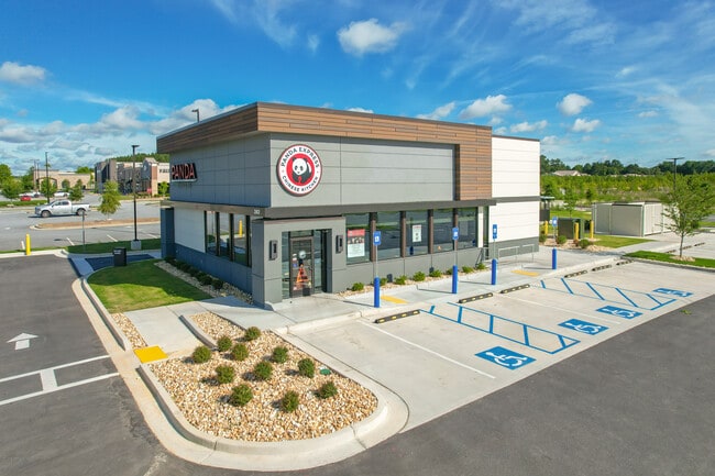
Property Record
372 Exchange Blvd, Bethlehem, GA 30620

Save to a Folder
{{folder.Name}}
{{folder.ListingIds.length}} Properties
{{folder.ListingIds.length}} Property
Create a New Folder
Property Detail
372 Exchange Blvd
WN16-009G
372 EXCHANGE BLVD (PB 61-207)
Stripcommercialcenter
Barrow
B-2
Georgia
B and X Area of moderate flood hazard, usually the area between the limits of the 100-year and 500-year floods.
1.34 AC
2025
S Barrow
2025
Atlanta
180503
Atlanta-Sandy Springs-Roswell, GA
13,439 SF
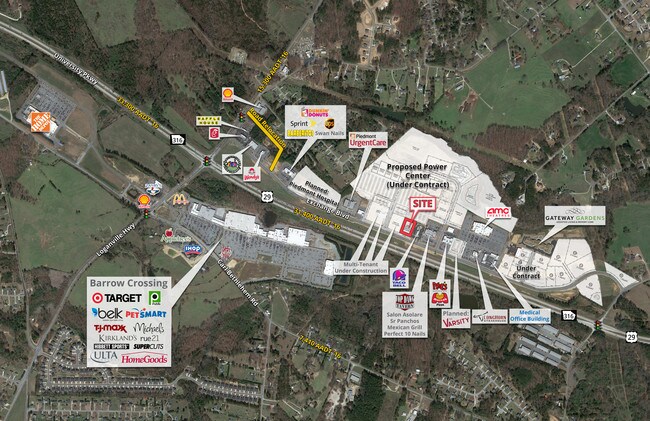
NEARBY LISTINGS FOR SALE OR LEASE
DEMOGRAPHICS near 372 Exchange Blvd
1 mile
3 mile
5 mile
2025 Total Population
2,652
22,381
53,117
2030 Population
3,031
25,392
59,859
Pop Growth 2025-2030
+ 14.29%
+ 13.45%
+ 12.69%
Average Age
36
35
37
2025 Total Households
928
7,250
17,997
HH Growth 2025-2030
+ 14.33%
+ 13.53%
+ 12.76%
Median Household Inc
$58,904
$73,085
$68,382
Avg Household Size
2.80
3.00
2.90
2025 Avg HH Vehicles
2.00
2.00
2.00
Median Home Value
$316,532
$293,851
$294,421
Median Year Built
2003
2004
2000
Nearby Places
Map Layers
Map Styles
 Street
 Aerial
Layers
 Traffic
 Biking
Places
Listings with unknown addresses are not visible on the map
- Restaurants
- Banks
- Shops
- Fitness
- Groceries
Nearby Properties
Address
Land Use
TOTAL SIZE
Lot Size
Zoning
Address
Land Use
TOTAL SIZE
Lot Size
Zoning
1,456 SF
1,732.81 AC
G
Address
Land Use
TOTAL SIZE
Lot Size
Zoning
10,128 SF
28.19 AC
R-3
Address
Land Use
TOTAL SIZE
Lot Size
Zoning
6,424 SF
11.63 AC
B-2,R-3
Address
Land Use
TOTAL SIZE
Lot Size
Zoning
26,789 SF
35.64 AC
C-3
Address
Land Use
TOTAL SIZE
Lot Size
Zoning
22,320 SF
15.90 AC
R-3
Address
Land Use
TOTAL SIZE
Lot Size
Zoning
120,000 SF
142.73 AC
AG
Address
Land Use
TOTAL SIZE
Lot Size
Zoning
2,046 SF
12.97 AC
B-2,R-3
Address
Land Use
TOTAL SIZE
Lot Size
Zoning
37,012 SF
10.55 AC
OI
Address
Land Use
TOTAL SIZE
Lot Size
Zoning
104,805 SF
12.54 AC
C-3
Address
Land Use
TOTAL SIZE
Lot Size
Zoning
2,398 SF
8.13 AC
R-3
Address
Land Use
TOTAL SIZE
Lot Size
Zoning
132,156 SF
10.05 AC
C-2
Address
Land Use
TOTAL SIZE
Lot Size
Zoning
1,188 SF
7.63 AC
R-3
Address
Land Use
TOTAL SIZE
Lot Size
Zoning
79,029 SF
9.72 AC
C-2
Address
Land Use
TOTAL SIZE
Lot Size
Zoning
3,370 SF
352.38 AC
G,TNPD
Address
Land Use
TOTAL SIZE
Lot Size
Zoning
60,540 SF
79.35 AC
AG
Address
Land Use
TOTAL SIZE
Lot Size
Zoning
38,550 SF
3.04 AC
C-2
Address
Land Use
TOTAL SIZE
Lot Size
Zoning
37,162 SF
4.62 AC
R-3
Address
Land Use
TOTAL SIZE
Lot Size
Zoning
55,420 SF
5.05 AC
C-3
Address
Land Use
TOTAL SIZE
Lot Size
Zoning
26,802 SF
5 AC
AG
Address
Land Use
TOTAL SIZE
Lot Size
Zoning
24,982 SF
16.08 AC
R-1
Address
Land Use
TOTAL SIZE
Lot Size
Zoning
8,916 SF
67.07 AC
R-3
Address
Land Use
TOTAL SIZE
Lot Size
Zoning
105.99 AC
C-3
Address
Land Use
TOTAL SIZE
Lot Size
Zoning
46,339 SF
2 AC
B-2
Address
Land Use
TOTAL SIZE
Lot Size
Zoning
76,768 SF
19.04 AC
AG
Address
Land Use
TOTAL SIZE
Lot Size
Zoning
45,296 SF
8.18 AC
B-2
Address
Land Use
TOTAL SIZE
Lot Size
Zoning
143,025 SF
9.30 AC
M-1
Address
Land Use
TOTAL SIZE
Lot Size
Zoning
19,483 SF
2.76 AC
B-2
Address
Land Use
TOTAL SIZE
Lot Size
Zoning
34,355 SF
24.48 AC
AG
Address
Land Use
TOTAL SIZE
Lot Size
Zoning
17.90 AC
R-3
Address
Land Use
TOTAL SIZE
Lot Size
Zoning
14,300 SF
5.77 AC
M-1
The World's #1 Commercial Real Estate Marketplace
Connect with us
© 2026 CoStar Group
The information above has been obtained from sources believed reliable. While we do not doubt its accuracy we have not verified it and make no guarantee, warranty or representation about it. It is your responsibility to independently confirm its accuracy and completeness. Any projections, opinions, assumptions, or estimates used are for example only and do not represent the current or future performance of the property. The value of this transaction to you depends on tax and other factors which should be evaluated by your tax, financial, and legal advisors. You and your advisors should conduct a careful, independent investigation of the property to determine to your satisfaction the suitability of the property for your needs.