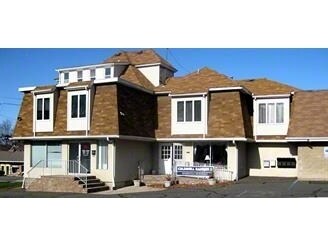
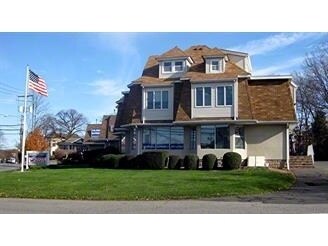
Property Record
372 Franklin Ave, Wyckoff, NJ 07481


Save to a Folder
{{folder.Name}}
{{folder.ListingIds.length}} Properties
{{folder.ListingIds.length}} Property
Create a New Folder
Property Detail
372 Franklin Ave
New York-Jersey City-White Plains, NY-NJ
121X272 IRR
70-00252-0000-00003
Bergen
Commercialnec
New Jersey
B1
3
B and X Area of moderate flood hazard, usually the area between the limits of the 100-year and 500-year floods.
0.76 AC
2025
Western Bergen
2026
Northern New Jersey
061200
NEARBY LISTINGS FOR SALE OR LEASE
DEMOGRAPHICS near 372 Franklin Ave
1 mile
3 mile
5 mile
2025 Total Population
7,437
70,479
198,601
2030 Population
7,701
73,163
205,277
Pop Growth 2025-2030
+ 3.55%
+ 3.81%
+ 3.36%
Average Age
43
43
42
2025 Total Households
2,605
24,444
69,602
HH Growth 2025-2030
+ 3.42%
+ 3.76%
+ 3.33%
Median Household Inc
$185,654
$172,618
$153,172
Avg Household Size
2.80
2.80
2.70
2025 Avg HH Vehicles
2.00
2.00
2.00
Median Home Value
$859,097
$827,221
$759,482
Median Year Built
1961
1964
1963
Nearby Places
Map Layers
Map Styles
 Street
 Aerial
Layers
 Traffic
 Biking
Places
Listings with unknown addresses are not visible on the map
- Restaurants
- Banks
- Shops
- Fitness
- Groceries
PUBLIC TRANSPORTATION
COMMUTER RAIL
Waldwick (Bergen County/Port Jervis Line - NJ Transit Commuter Rail (NJ Transit), Main/Port Jervis Line - NJ Transit Commuter Rail (NJ Transit))
Drive
Walk
Distance
Waldwick (Bergen County/Port Jervis Line - NJ Transit Commuter Rail (NJ Transit), Main/Port Jervis Line - NJ Transit Commuter Rail (NJ Transit))
7 min
3.3 mi
Allendale (Bergen County/Port Jervis Line - NJ Transit Commuter Rail (NJ Transit), Main/Port Jervis Line - NJ Transit Commuter Rail (NJ Transit))
Drive
Walk
Distance
Allendale (Bergen County/Port Jervis Line - NJ Transit Commuter Rail (NJ Transit), Main/Port Jervis Line - NJ Transit Commuter Rail (NJ Transit))
7 min
3.5 mi
AIRPORT
LaGuardia
Drive
Walk
Distance
LaGuardia
42 min
28.6 mi
Newark Liberty International
Drive
Walk
Distance
Newark Liberty International
36 min
28.9 mi
Westchester County
Drive
Walk
Distance
Westchester County
56 min
41.8 mi
Freight Ports
Port Newark Container Terminal
Drive
Walk
Distance
Port Newark Container Terminal
41 min
28.0 mi
Nearby Properties
Address
Land Use
TOTAL SIZE
Lot Size
Zoning
Address
Land Use
TOTAL SIZE
Lot Size
Zoning
128.12 AC
HOBR
Address
Land Use
TOTAL SIZE
Lot Size
Zoning
88.72 AC
ORL
Address
Land Use
TOTAL SIZE
Lot Size
Zoning
2,252 SF
19.04 AC
Address
Land Use
TOTAL SIZE
Lot Size
Zoning
61.98 AC
Address
Land Use
TOTAL SIZE
Lot Size
Zoning
40.40 AC
PU
Address
Land Use
TOTAL SIZE
Lot Size
Zoning
80.80 AC
Address
Land Use
TOTAL SIZE
Lot Size
Zoning
23.19 AC
R1
Address
Land Use
TOTAL SIZE
Lot Size
Zoning
Address
Land Use
TOTAL SIZE
Lot Size
Zoning
20.30 AC
Address
Land Use
TOTAL SIZE
Lot Size
Zoning
3,165 SF
2.07 AC
VC2
Address
Land Use
TOTAL SIZE
Lot Size
Zoning
12.69 AC
A40
Address
Land Use
TOTAL SIZE
Lot Size
Zoning
Address
Land Use
TOTAL SIZE
Lot Size
Zoning
6 AC
IP-2
Address
Land Use
TOTAL SIZE
Lot Size
Zoning
3.63 AC
Address
Land Use
TOTAL SIZE
Lot Size
Zoning
74,278 SF
6.91 AC
C2
Address
Land Use
TOTAL SIZE
Lot Size
Zoning
79,562 SF
10.33 AC
AHO3
Address
Land Use
TOTAL SIZE
Lot Size
Zoning
12.45 AC
A225
Address
Land Use
TOTAL SIZE
Lot Size
Zoning
12.49 AC
AHO1
Address
Land Use
TOTAL SIZE
Lot Size
Zoning
98.41 AC
A130
Address
Land Use
TOTAL SIZE
Lot Size
Zoning
2 AC
R110
Address
Land Use
TOTAL SIZE
Lot Size
Zoning
129,119 SF
8.23 AC
B3
Address
Land Use
TOTAL SIZE
Lot Size
Zoning
13.39 AC
MFAH
Address
Land Use
TOTAL SIZE
Lot Size
Zoning
Address
Land Use
TOTAL SIZE
Lot Size
Zoning
26.70 AC
Address
Land Use
TOTAL SIZE
Lot Size
Zoning
8.07 AC
SR
Address
Land Use
TOTAL SIZE
Lot Size
Zoning
2,005 SF
4.62 AC
A225
Address
Land Use
TOTAL SIZE
Lot Size
Zoning
2,738 SF
1.77 AC
RB
Address
Land Use
TOTAL SIZE
Lot Size
Zoning
2,254 SF
5.37 AC
I
Address
Land Use
TOTAL SIZE
Lot Size
Zoning
13.61 AC
Address
Land Use
TOTAL SIZE
Lot Size
Zoning
3,421 SF
15.46 AC
The World's #1 Commercial Real Estate Marketplace
Connect with us
© 2026 CoStar Group
The information above has been obtained from sources believed reliable. While we do not doubt its accuracy we have not verified it and make no guarantee, warranty or representation about it. It is your responsibility to independently confirm its accuracy and completeness. Any projections, opinions, assumptions, or estimates used are for example only and do not represent the current or future performance of the property. The value of this transaction to you depends on tax and other factors which should be evaluated by your tax, financial, and legal advisors. You and your advisors should conduct a careful, independent investigation of the property to determine to your satisfaction the suitability of the property for your needs.