Property Record
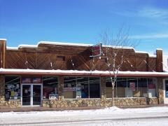
372 Main St, Lander, WY 82520

Property Detail
372 Main St
3399-18-1-51-014.00
ORIGINAL TOWN OF LANDER BLK 16 EAST 9 LOT 12 & ALL LOT 13 WD 2024-1456141
Storebuilding
Fremont
C and X Area of minimal flood hazard, usually depicted on FIRMs as above the 500-year flood level.
Wyoming
2024
12,13
2025
0.20 AC
000200
Other Market Areas
7,847 SF
Riverton, WY
NEARBY LISTINGS FOR SALE OR LEASE
-
-
View all Lander listings for sale on LoopNet.com
DEMOGRAPHICS near 372 Main St
1 mile
3 mile
5 mile
2025 Total Population
7,399
9,312
10,203
2030 Population
7,498
9,430
10,318
Pop Growth 2025-2030
+ 1.34%
+ 1.27%
+ 1.13%
Average Age
41
41
42
2025 Total Households
3,029
3,815
4,176
HH Growth 2025-2030
+ 1.22%
+ 1.13%
+ 1.03%
Median Household Inc
$70,405
$71,159
$71,221
Avg Household Size
2.30
2.30
2.30
2025 Avg HH Vehicles
2.00
2.00
2.00
Median Home Value
$338,938
$341,956
$343,235
Median Year Built
1973
1975
1975
Nearby Places
Map Layers
Map Styles
 Street
 Aerial
Layers
 Traffic
 Biking
Places
Listings with unknown addresses are not visible on the map
- Restaurants
- Banks
- Shops
- Fitness
- Groceries
Nearby Properties
Address
Land Use
TOTAL SIZE
Lot Size
Zoning
Address
Land Use
TOTAL SIZE
Lot Size
Zoning
105,521 SF
25.54 AC
Address
Land Use
TOTAL SIZE
Lot Size
Zoning
44,556 SF
4.60 AC
Address
Land Use
TOTAL SIZE
Lot Size
Zoning
34,708 SF
2.06 AC
Address
Land Use
TOTAL SIZE
Lot Size
Zoning
46,064 SF
1.94 AC
Address
Land Use
TOTAL SIZE
Lot Size
Zoning
72,320 SF
3.61 AC
Address
Land Use
TOTAL SIZE
Lot Size
Zoning
20,488 SF
0.61 AC
Address
Land Use
TOTAL SIZE
Lot Size
Zoning
13,990 SF
4.60 AC
Address
Land Use
TOTAL SIZE
Lot Size
Zoning
35,219 SF
0.72 AC
Address
Land Use
TOTAL SIZE
Lot Size
Zoning
20,282 SF
4.16 AC
Address
Land Use
TOTAL SIZE
Lot Size
Zoning
22,280 SF
3.60 AC
Address
Land Use
TOTAL SIZE
Lot Size
Zoning
18,880 SF
6.01 AC
Address
Land Use
TOTAL SIZE
Lot Size
Zoning
20,193 SF
1.55 AC
Address
Land Use
TOTAL SIZE
Lot Size
Zoning
49,757 SF
4.34 AC
Address
Land Use
TOTAL SIZE
Lot Size
Zoning
35,145 SF
2.14 AC
Address
Land Use
TOTAL SIZE
Lot Size
Zoning
23,379 SF
1.07 AC
Address
Land Use
TOTAL SIZE
Lot Size
Zoning
27,010 SF
4.03 AC
Address
Land Use
TOTAL SIZE
Lot Size
Zoning
7,998 SF
0.52 AC
Address
Land Use
TOTAL SIZE
Lot Size
Zoning
20,524 SF
0.34 AC
Address
Land Use
TOTAL SIZE
Lot Size
Zoning
12,428 SF
0.34 AC
Address
Land Use
TOTAL SIZE
Lot Size
Zoning
16,860 SF
0.31 AC
Address
Land Use
TOTAL SIZE
Lot Size
Zoning
35,868 SF
1.83 AC
Address
Land Use
TOTAL SIZE
Lot Size
Zoning
22,900 SF
2.20 AC
Address
Land Use
TOTAL SIZE
Lot Size
Zoning
35,700 SF
3.54 AC
Address
Land Use
TOTAL SIZE
Lot Size
Zoning
62,603 SF
4.07 AC
Address
Land Use
TOTAL SIZE
Lot Size
Zoning
27,352 SF
0.69 AC
Address
Land Use
TOTAL SIZE
Lot Size
Zoning
21,745 SF
1.64 AC
Address
Land Use
TOTAL SIZE
Lot Size
Zoning
19,707 SF
2.01 AC
Address
Land Use
TOTAL SIZE
Lot Size
Zoning
9,332 SF
0.69 AC
Address
Land Use
TOTAL SIZE
Lot Size
Zoning
6,708 SF
0.98 AC
Address
Land Use
TOTAL SIZE
Lot Size
Zoning
23,698 SF
0.69 AC
The World's #1 Commercial Real Estate Marketplace
Connect with us
© 2026 CoStar Group
The information above has been obtained from sources believed reliable. While we do not doubt its accuracy we have not verified it and make no guarantee, warranty or representation about it. It is your responsibility to independently confirm its accuracy and completeness. Any projections, opinions, assumptions, or estimates used are for example only and do not represent the current or future performance of the property. The value of this transaction to you depends on tax and other factors which should be evaluated by your tax, financial, and legal advisors. You and your advisors should conduct a careful, independent investigation of the property to determine to your satisfaction the suitability of the property for your needs.