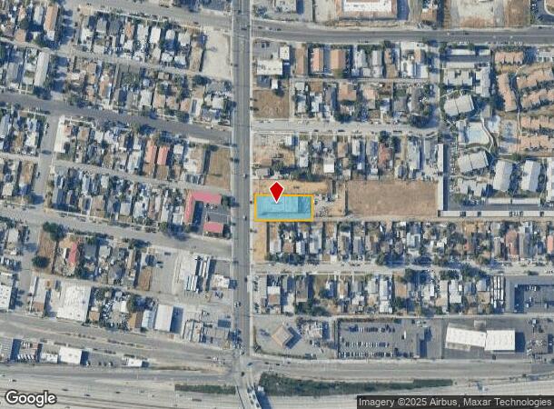
Property Record
372 N Mount Vernon Ave, Colton, CA 92324
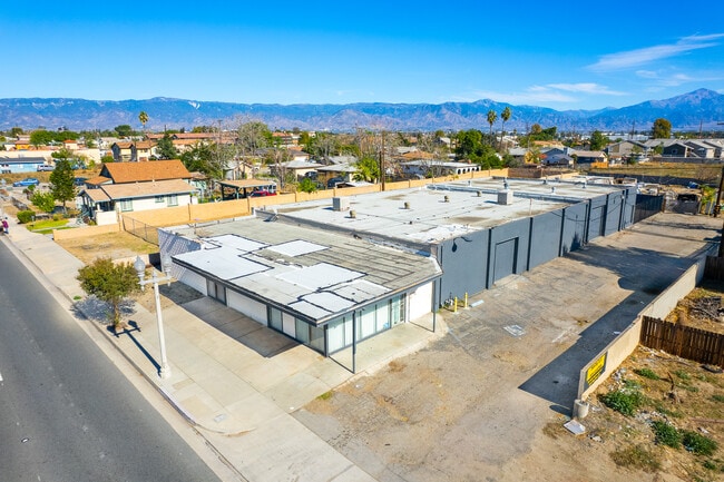

This Property Is For Sale
NEARBY LISTINGS FOR SALE OR LEASE
Property Detail
372 N Mount Vernon Ave
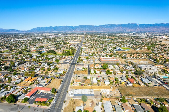
Riverside-San Bernardino-Ontario, CA
Rancho San Bernardino
0164-163-05
R S B S 82 FT W 204 FT LOT 7 BLK 54
Warehouse
San Bernardino
X
California
06071C8679J
7
2024
0.38 AC
2025
San Bernardino
007002
Inland Empire (California)
8,880 SF
DEMOGRAPHICS near 372 N Mount Vernon Ave
1 Mile
3 Mile
5 Mile
2024 Total Population
12,579
94,747
286,104
2029 Population
12,723
96,200
291,375
Pop Growth 2024-2029
+ 1.14%
+ 1.53%
+ 1.84%
Average Age
34
35
35
2024 Total Households
3,531
28,999
82,385
HH Growth 2024-2029
+ 1.16%
+ 1.69%
+ 1.94%
Median Household Inc
$47,968
$60,981
$61,457
Avg Household Size
3.50
3.20
3.30
2024 Avg HH Vehicles
2.00
2.00
2.00
Median Home Value
$342,513
$358,544
$363,611
Median Year Built
1958
1976
1973
Nearby Places
- Restaurants
- Banks
- Shops
- Fitness
- Groceries
PUBLIC TRANSPORTATION
COMMUTER RAIL
San Bernardino (Inland Empire-Orange County Line - Southern California Regional Rail Authority (Metrolink), San Bernardino Line - Southern California Regional Rail Authority (Metrolink))
DRIVE
WALK
Distance
San Bernardino (Inland Empire-Orange County Line - Southern California Regional Rail Authority (Metrolink), San Bernardino Line - Southern California Regional Rail Authority (Metrolink))
7 min
2.9 mi
DRIVE
WALK
Distance
8 min
3.4 mi
AIRPORT
Ontario International
DRIVE
WALK
Distance
Ontario International
25 min
18.3 mi
John Wayne/Orange County
DRIVE
WALK
Distance
John Wayne/Orange County
60 min
49.8 mi
Freight Ports
Port of Long Beach
DRIVE
WALK
Distance
Port of Long Beach
83 min
63.8 mi
Nearby Properties
Address
Land Use
TOTAL SIZE
Lot Size
Zoning
Address
Land Use
TOTAL SIZE
Lot Size
Zoning
457,253 SF
20.14 AC
Address
Land Use
TOTAL SIZE
Lot Size
Zoning
308,030 SF
16.20 AC
Address
Land Use
TOTAL SIZE
Lot Size
Zoning
1,032,072 SF
61.74 AC
Address
Land Use
TOTAL SIZE
Lot Size
Zoning
411,707 SF
19.34 AC
Address
Land Use
TOTAL SIZE
Lot Size
Zoning
330,420 SF
15.31 AC
Address
Land Use
TOTAL SIZE
Lot Size
Zoning
340,120 SF
36.36 AC
Address
Land Use
TOTAL SIZE
Lot Size
Zoning
1,081,199 SF
49.77 AC
Address
Land Use
TOTAL SIZE
Lot Size
Zoning
300,188 SF
11.98 AC
Address
Land Use
TOTAL SIZE
Lot Size
Zoning
182,624 SF
16.07 AC
Address
Land Use
TOTAL SIZE
Lot Size
Zoning
245,476 SF
15.61 AC
Address
Land Use
TOTAL SIZE
Lot Size
Zoning
758,180 SF
31.86 AC
Address
Land Use
TOTAL SIZE
Lot Size
Zoning
391,468 SF
16.73 AC
Address
Land Use
TOTAL SIZE
Lot Size
Zoning
210,418 SF
12.09 AC
Address
Land Use
TOTAL SIZE
Lot Size
Zoning
225,324 SF
11.03 AC
Address
Land Use
TOTAL SIZE
Lot Size
Zoning
474,680 SF
17.95 AC
Address
Land Use
TOTAL SIZE
Lot Size
Zoning
851,880 SF
42.20 AC
Address
Land Use
TOTAL SIZE
Lot Size
Zoning
178,400 SF
8.23 AC
Address
Land Use
TOTAL SIZE
Lot Size
Zoning
549,796 SF
13.61 AC
Address
Land Use
TOTAL SIZE
Lot Size
Zoning
182,446 SF
9.01 AC
Address
Land Use
TOTAL SIZE
Lot Size
Zoning
147,744 SF
14.58 AC
Address
Land Use
TOTAL SIZE
Lot Size
Zoning
151,859 SF
7.23 AC
Address
Land Use
TOTAL SIZE
Lot Size
Zoning
592,710 SF
28.89 AC
Address
Land Use
TOTAL SIZE
Lot Size
Zoning
318,940 SF
14.26 AC
Address
Land Use
TOTAL SIZE
Lot Size
Zoning
154,639 SF
6.87 AC
Address
Land Use
TOTAL SIZE
Lot Size
Zoning
16,000 SF
11.17 AC
Address
Land Use
TOTAL SIZE
Lot Size
Zoning
413,953 SF
19.58 AC
Address
Land Use
TOTAL SIZE
Lot Size
Zoning
153,093 SF
2.69 AC
Address
Land Use
TOTAL SIZE
Lot Size
Zoning
122,738 SF
10.77 AC
Address
Land Use
TOTAL SIZE
Lot Size
Zoning
345,237 SF
14.52 AC
Address
Land Use
TOTAL SIZE
Lot Size
Zoning
409,838 SF
14.53 AC
The World's #1 Commercial Real Estate Marketplace
Connect with us
© 2025 CoStar Group
The information above has been obtained from sources believed reliable. While we do not doubt its accuracy we have not verified it and make no guarantee, warranty or representation about it. It is your responsibility to independently confirm its accuracy and completeness. Any projections, opinions, assumptions, or estimates used are for example only and do not represent the current or future performance of the property. The value of this transaction to you depends on tax and other factors which should be evaluated by your tax, financial, and legal advisors. You and your advisors should conduct a careful, independent investigation of the property to determine to your satisfaction the suitability of the property for your needs.