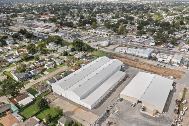
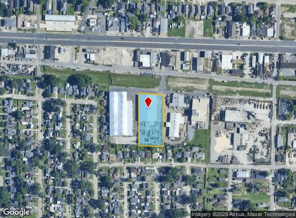
Property Record
3714 Robertson St, Metairie, LA 70001
NEARBY LISTINGS FOR SALE OR LEASE
Property Detail
3714 Robertson St
New Orleans-Metairie, LA
Bechtel Gilmore
0820015906
LOT W-2 BECHTEL GILMORE ADD
Realpropertynec
Jefferson
X
Louisiana
22051C0185F
w2
2024
1.41 AC
2024
Metairie
028900
New Orleans/Metairie/Kenner
DEMOGRAPHICS near 3714 Robertson St
1 Mile
3 Mile
5 Mile
2024 Total Population
15,900
122,308
306,526
2029 Population
15,279
117,675
294,608
Pop Growth 2024-2029
(3.91%)
(3.79%)
(3.89%)
Average Age
44
42
41
2024 Total Households
7,550
55,906
132,281
HH Growth 2024-2029
(4.07%)
(3.91%)
(4.06%)
Median Household Inc
$61,402
$60,516
$62,103
Avg Household Size
2.10
2.10
2.20
2024 Avg HH Vehicles
2.00
2.00
2.00
Median Home Value
$250,205
$283,055
$296,981
Median Year Built
1958
1968
1965
Nearby Places
Map Layers
Map Styles
 Street
 Aerial
- Restaurants
- Banks
- Shops
- Fitness
- Groceries
PUBLIC TRANSPORTATION
COMMUTER RAIL
DRIVE
WALK
Distance
13 min
6.3 mi
AIRPORT
Louis Armstrong New Orleans International
DRIVE
WALK
Distance
Louis Armstrong New Orleans International
17 min
9.2 mi
Freight Ports
Port of New Orleans
DRIVE
WALK
Distance
Port of New Orleans
19 min
8.4 mi
SALE & LEASE HISTORY
LISTING DATE
SALE/LEASE

Apr 10, 2025
For Lease
Nearby Properties
Address
Land Use
TOTAL SIZE
Lot Size
Zoning
Address
Land Use
TOTAL SIZE
Lot Size
Zoning
22.63 AC
Address
Land Use
TOTAL SIZE
Lot Size
Zoning
23.74 AC
R1A
Address
Land Use
TOTAL SIZE
Lot Size
Zoning
50.06 AC
R1A
Address
Land Use
TOTAL SIZE
Lot Size
Zoning
0.14 AC
Address
Land Use
TOTAL SIZE
Lot Size
Zoning
35.06 AC
Address
Land Use
TOTAL SIZE
Lot Size
Zoning
4.31 AC
BC2
Address
Land Use
TOTAL SIZE
Lot Size
Zoning
42.34 AC
Address
Land Use
TOTAL SIZE
Lot Size
Zoning
Address
Land Use
TOTAL SIZE
Lot Size
Zoning
66.97 AC
LI
Address
Land Use
TOTAL SIZE
Lot Size
Zoning
Address
Land Use
TOTAL SIZE
Lot Size
Zoning
Address
Land Use
TOTAL SIZE
Lot Size
Zoning
7.98 AC
R1A
Address
Land Use
TOTAL SIZE
Lot Size
Zoning
Address
Land Use
TOTAL SIZE
Lot Size
Zoning
66.02 AC
Address
Land Use
TOTAL SIZE
Lot Size
Zoning
Address
Land Use
TOTAL SIZE
Lot Size
Zoning
Address
Land Use
TOTAL SIZE
Lot Size
Zoning
39,963 SF
110.36 AC
OS-N
Address
Land Use
TOTAL SIZE
Lot Size
Zoning
4.90 AC
R2
Address
Land Use
TOTAL SIZE
Lot Size
Zoning
Address
Land Use
TOTAL SIZE
Lot Size
Zoning
0.69 AC
Address
Land Use
TOTAL SIZE
Lot Size
Zoning
0.20 AC
Address
Land Use
TOTAL SIZE
Lot Size
Zoning
0.12 AC
Address
Land Use
TOTAL SIZE
Lot Size
Zoning
14.56 AC
R1A
Address
Land Use
TOTAL SIZE
Lot Size
Zoning
Address
Land Use
TOTAL SIZE
Lot Size
Zoning
0.11 AC
Address
Land Use
TOTAL SIZE
Lot Size
Zoning
10.76 AC
C2
Address
Land Use
TOTAL SIZE
Lot Size
Zoning
Address
Land Use
TOTAL SIZE
Lot Size
Zoning
0.15 AC
Address
Land Use
TOTAL SIZE
Lot Size
Zoning
22.61 AC
M2
Address
Land Use
TOTAL SIZE
Lot Size
Zoning
1.85 AC
GO2
The World's #1 Commercial Real Estate Marketplace
Connect with us
© 2025 CoStar Group
The information above has been obtained from sources believed reliable. While we do not doubt its accuracy we have not verified it and make no guarantee, warranty or representation about it. It is your responsibility to independently confirm its accuracy and completeness. Any projections, opinions, assumptions, or estimates used are for example only and do not represent the current or future performance of the property. The value of this transaction to you depends on tax and other factors which should be evaluated by your tax, financial, and legal advisors. You and your advisors should conduct a careful, independent investigation of the property to determine to your satisfaction the suitability of the property for your needs.