Property Record
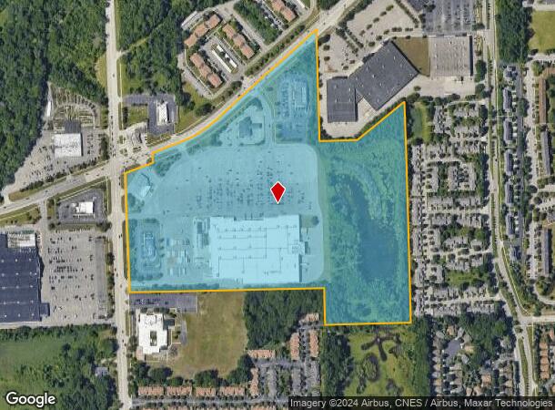
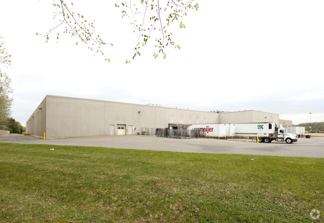
37201 Warren Rd, Westland, MI 48185

NEARBY LISTINGS FOR SALE OR LEASE
Property Detail
37201 Warren Rd
Detroit-Warren-Dearborn, MI
South
56-030-99-0006-707
PART OF THE NW 1/4 OF SEC 8 T2S R9E DESCRIBED AS BEGINNING AT A POINT ON THE E RIGHT OF WAY LINE OF NEWBURGH ROAD WHICH IS N, 230.96 FT ALONG THE W LINE OF SAID SEC 8 AND S 89D 26M 00S E 60.00 FT FROM THE W 1/4 CORNER OF SAID SEC 8; TH FROM SAID POB
Wholesaleoutletdiscountstore
Wayne
X
Michigan
26163C0208E
0006
2025
39.67 AC
2025
Southern I-275 Corridor
568900
Detroit
232,858 SF
DEMOGRAPHICS near 37201 Warren Rd
1 Mile
3 Mile
5 Mile
2024 Total Population
11,719
94,457
242,641
2029 Population
11,225
90,517
232,689
Pop Growth 2024-2029
(4.22%)
(4.17%)
(4.10%)
Average Age
42
42
41
2024 Total Households
6,058
41,794
101,456
HH Growth 2024-2029
(4.31%)
(4.16%)
(4.11%)
Median Household Inc
$42,357
$65,986
$72,942
Avg Household Size
1.90
2.20
2.30
2024 Avg HH Vehicles
1.00
2.00
2.00
Median Home Value
$153,008
$184,250
$203,617
Median Year Built
1979
1971
1968
Nearby Places
Map Layers
Map Styles
 Street
 Aerial
- Restaurants
- Banks
- Shops
- Fitness
- Groceries
PUBLIC TRANSPORTATION
AIRPORT
Detroit Metro Wayne County
DRIVE
WALK
Distance
Detroit Metro Wayne County
23 min
16.5 mi
Windsor International
DRIVE
WALK
Distance
Windsor International
54 min
34.5 mi
Freight Ports
Port of Toledo
DRIVE
WALK
Distance
Port of Toledo
73 min
58.1 mi
Nearby Properties
Address
Land Use
TOTAL SIZE
Lot Size
Zoning
Address
Land Use
TOTAL SIZE
Lot Size
Zoning
741,173 SF
63.81 AC
Address
Land Use
TOTAL SIZE
Lot Size
Zoning
3,733,882 SF
183.17 AC
M-2
Address
Land Use
TOTAL SIZE
Lot Size
Zoning
400,857 SF
27.44 AC
RP
Address
Land Use
TOTAL SIZE
Lot Size
Zoning
37.30 AC
MR
Address
Land Use
TOTAL SIZE
Lot Size
Zoning
167,491 SF
18.59 AC
Address
Land Use
TOTAL SIZE
Lot Size
Zoning
408,122 SF
23.31 AC
MR
Address
Land Use
TOTAL SIZE
Lot Size
Zoning
21.71 AC
MR
Address
Land Use
TOTAL SIZE
Lot Size
Zoning
311,556 SF
23.17 AC
C-3
Address
Land Use
TOTAL SIZE
Lot Size
Zoning
114,894 SF
4.94 AC
ARC
Address
Land Use
TOTAL SIZE
Lot Size
Zoning
352,514 SF
26.40 AC
Address
Land Use
TOTAL SIZE
Lot Size
Zoning
480,910 SF
26.32 AC
Address
Land Use
TOTAL SIZE
Lot Size
Zoning
20.91 AC
Address
Land Use
TOTAL SIZE
Lot Size
Zoning
395,148 SF
9.67 AC
Address
Land Use
TOTAL SIZE
Lot Size
Zoning
169,489 SF
14.51 AC
R-6
Address
Land Use
TOTAL SIZE
Lot Size
Zoning
Address
Land Use
TOTAL SIZE
Lot Size
Zoning
954,882 SF
47.92 AC
LI-2
Address
Land Use
TOTAL SIZE
Lot Size
Zoning
249,795 SF
21.17 AC
Address
Land Use
TOTAL SIZE
Lot Size
Zoning
176,396 SF
11.76 AC
Address
Land Use
TOTAL SIZE
Lot Size
Zoning
188,958 SF
7.71 AC
Address
Land Use
TOTAL SIZE
Lot Size
Zoning
286,188 SF
40.21 AC
Address
Land Use
TOTAL SIZE
Lot Size
Zoning
285,136 SF
15.28 AC
Address
Land Use
TOTAL SIZE
Lot Size
Zoning
172,094 SF
11.84 AC
M-2
Address
Land Use
TOTAL SIZE
Lot Size
Zoning
16.03 AC
MR
Address
Land Use
TOTAL SIZE
Lot Size
Zoning
206,130 SF
14.12 AC
Address
Land Use
TOTAL SIZE
Lot Size
Zoning
66,670 SF
11.20 AC
C-3
Address
Land Use
TOTAL SIZE
Lot Size
Zoning
243,371 SF
16.04 AC
Address
Land Use
TOTAL SIZE
Lot Size
Zoning
269,649 SF
18.27 AC
LI-1
Address
Land Use
TOTAL SIZE
Lot Size
Zoning
199,952 SF
13.06 AC
Address
Land Use
TOTAL SIZE
Lot Size
Zoning
Address
Land Use
TOTAL SIZE
Lot Size
Zoning
76,430 SF
13.61 AC
C-3
The World's #1 Commercial Real Estate Marketplace
Connect with us
© 2026 CoStar Group
The information above has been obtained from sources believed reliable. While we do not doubt its accuracy we have not verified it and make no guarantee, warranty or representation about it. It is your responsibility to independently confirm its accuracy and completeness. Any projections, opinions, assumptions, or estimates used are for example only and do not represent the current or future performance of the property. The value of this transaction to you depends on tax and other factors which should be evaluated by your tax, financial, and legal advisors. You and your advisors should conduct a careful, independent investigation of the property to determine to your satisfaction the suitability of the property for your needs.