Property Record
37228 10Th St E, Palmdale, CA 93550


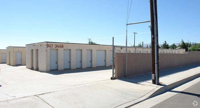

Property Detail
37228 10Th St E
3012-024-036
FOR DESC SEE ASSESSORS MAPS EX OF ST POR SW 1/4 T 6 N R 12 W
Publicstorage
Los Angeles
PDM2*
California
B and X Area of moderate flood hazard, usually the area between the limits of the 100-year and 500-year floods.
2.56 AC
2024
Antelope Valley
2025
Los Angeles
910505
Los Angeles-Long Beach-Glendale, CA
10,020 SF
NEARBY LISTINGS FOR SALE OR LEASE
-
-
View all Palmdale listings for sale on LoopNet.com
DEMOGRAPHICS near 37228 10Th St E
1 mile
3 mile
5 mile
2025 Total Population
14,297
82,831
142,483
2030 Population
14,669
82,654
141,822
Pop Growth 2025-2030
+ 2.60%
(0.21%)
(0.46%)
Average Age
36
36
37
2025 Total Households
4,265
24,217
40,571
HH Growth 2025-2030
+ 3.26%
(0.20%)
(0.52%)
Median Household Inc
$63,697
$64,700
$74,720
Avg Household Size
3.30
3.40
3.40
2025 Avg HH Vehicles
2.00
2.00
2.00
Median Home Value
$345,918
$399,790
$434,925
Median Year Built
1988
1985
1987
Nearby Places
Map Layers
Map Styles
 Street
 Aerial
Transit
 Traffic
 Biking
Places
Listings with unknown addresses are not visible on the map
- Restaurants
- Banks
- Shops
- Fitness
- Groceries
PUBLIC TRANSPORTATION
COMMUTER RAIL
Palmdale (Antelope Valley Line - Southern California Regional Rail Authority (Metrolink))
Drive
Walk
Distance
Palmdale (Antelope Valley Line - Southern California Regional Rail Authority (Metrolink))
5 min
2.5 mi
Vincent Grade/Acton (Antelope Valley Line - Southern California Regional Rail Authority (Metrolink))
Drive
Walk
Distance
Vincent Grade/Acton (Antelope Valley Line - Southern California Regional Rail Authority (Metrolink))
9 min
5.3 mi
AIRPORT
Bob Hope
Drive
Walk
Distance
Bob Hope
58 min
48.1 mi
SALE & LEASE HISTORY
LISTING DATE
SALE/LEASE

Sep 24, 2016
For Sale
Jan 13, 2018
For Sale
Dec 25, 2017
For Sale
Nearby Properties
Address
Land Use
TOTAL SIZE
Lot Size
Zoning
Address
Land Use
TOTAL SIZE
Lot Size
Zoning
358,828 SF
26.23 AC
PDR17000
Address
Land Use
TOTAL SIZE
Lot Size
Zoning
167,366 SF
15.36 AC
PDC3
Address
Land Use
TOTAL SIZE
Lot Size
Zoning
221,827 SF
14.90 AC
PDRPD10U-R
Address
Land Use
TOTAL SIZE
Lot Size
Zoning
157,021 SF
PDRN4
Address
Land Use
TOTAL SIZE
Lot Size
Zoning
59,577 SF
0.59 AC
PDR17000
Address
Land Use
TOTAL SIZE
Lot Size
Zoning
209,328 SF
6.35 AC
PDC3-RPD15
Address
Land Use
TOTAL SIZE
Lot Size
Zoning
71,394 SF
2.93 AC
PDCPD*
Address
Land Use
TOTAL SIZE
Lot Size
Zoning
76,609 SF
3.61 AC
PDM2
Address
Land Use
TOTAL SIZE
Lot Size
Zoning
80,981 SF
7.11 AC
PDC3
Address
Land Use
TOTAL SIZE
Lot Size
Zoning
55,079 SF
1.98 AC
PDCPD*
Address
Land Use
TOTAL SIZE
Lot Size
Zoning
71,974 SF
3.83 AC
PDCPD*
Address
Land Use
TOTAL SIZE
Lot Size
Zoning
207,582 SF
18.74 AC
PDR1*
Address
Land Use
TOTAL SIZE
Lot Size
Zoning
81,790 SF
5.70 AC
PDR1*
Address
Land Use
TOTAL SIZE
Lot Size
Zoning
78,176 SF
6.11 AC
PDR1*
Address
Land Use
TOTAL SIZE
Lot Size
Zoning
108,762 SF
4.22 AC
PDR3
Address
Land Use
TOTAL SIZE
Lot Size
Zoning
81,512 SF
4.25 AC
PDR1*
Address
Land Use
TOTAL SIZE
Lot Size
Zoning
67,560 SF
5.12 AC
PDR1*
Address
Land Use
TOTAL SIZE
Lot Size
Zoning
63,944 SF
2.33 AC
PDR1-7000
Address
Land Use
TOTAL SIZE
Lot Size
Zoning
171,078 SF
10.26 AC
PDR3DP*
Address
Land Use
TOTAL SIZE
Lot Size
Zoning
43,898 SF
4 AC
PDR1*
Address
Land Use
TOTAL SIZE
Lot Size
Zoning
153,879 SF
12.37 AC
PDR3*
Address
Land Use
TOTAL SIZE
Lot Size
Zoning
34,613 SF
PDCPD*
Address
Land Use
TOTAL SIZE
Lot Size
Zoning
106,048 SF
9.82 AC
PDR3*
Address
Land Use
TOTAL SIZE
Lot Size
Zoning
225,054 SF
PDC3
Address
Land Use
TOTAL SIZE
Lot Size
Zoning
154,988 SF
PDR3*
Address
Land Use
TOTAL SIZE
Lot Size
Zoning
28,434 SF
3.94 AC
PDCP
Address
Land Use
TOTAL SIZE
Lot Size
Zoning
85,392 SF
4.36 AC
PDR3*
Address
Land Use
TOTAL SIZE
Lot Size
Zoning
41,808 SF
2.82 AC
PDR3*
Address
Land Use
TOTAL SIZE
Lot Size
Zoning
41,808 SF
4.06 AC
PDR3*
Address
Land Use
TOTAL SIZE
Lot Size
Zoning
41,808 SF
3.65 AC
PDR3*
The World's #1 Commercial Real Estate Marketplace
Connect with us
© 2026 CoStar Group
The information above has been obtained from sources believed reliable. While we do not doubt its accuracy we have not verified it and make no guarantee, warranty or representation about it. It is your responsibility to independently confirm its accuracy and completeness. Any projections, opinions, assumptions, or estimates used are for example only and do not represent the current or future performance of the property. The value of this transaction to you depends on tax and other factors which should be evaluated by your tax, financial, and legal advisors. You and your advisors should conduct a careful, independent investigation of the property to determine to your satisfaction the suitability of the property for your needs.