Property Record
3725 Morganford Rd, Saint Louis, MO 63116
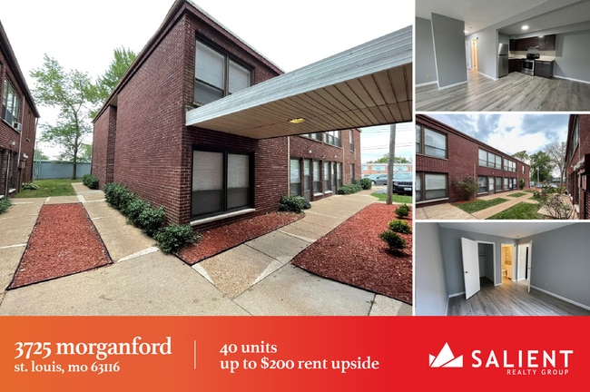
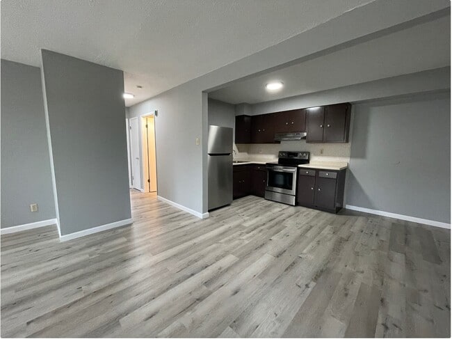
This Property Is For Sale
NEARBY LISTINGS FOR SALE OR LEASE
Property Detail
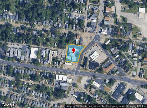
3725 Morganford Rd
St. Louis, MO-IL
Becks Of Tholozan Addn
4170-03-0370-0
C.B.4170-E MORGANFORD RD 240.65 / 225.77 X 155.42 / 225 BECKS OF THOLOZAN ADDN BLOCK 2 LOTS 36 & 37 & 38 & 39 & 40
Multifamilydwelling
St. Louis City
X
Missouri
2903850084C
36-40
2024
1.02 AC
2025
Tower Grove South
115200
St. Louis
30,234 SF
DEMOGRAPHICS near 3725 Morganford Rd
1 Mile
3 Mile
5 Mile
2024 Total Population
22,544
143,333
317,476
2029 Population
20,596
132,844
301,676
Pop Growth 2024-2029
(8.64%)
(7.32%)
(4.98%)
Average Age
39
39
39
2024 Total Households
11,159
69,101
150,594
HH Growth 2024-2029
(8.55%)
(7.29%)
(5.15%)
Median Household Inc
$50,515
$57,793
$58,078
Avg Household Size
2.00
2.00
2.00
2024 Avg HH Vehicles
1.00
1.00
1.00
Median Home Value
$159,543
$187,267
$195,265
Median Year Built
1946
1946
1948
Nearby Places
- Restaurants
- Banks
- Shops
- Fitness
- Groceries
PUBLIC TRANSPORTATION
COMMUTER RAIL
Cortex Metrolink Station (MetroLink Blue Line - Metro St. Louis)
DRIVE
WALK
Distance
Cortex Metrolink Station (MetroLink Blue Line - Metro St. Louis)
9 min
3.3 mi
Shrewsbury-Lansdowne (Shrewsbury-Lansdowne I-44 Emerson Park - St. Louis MetroLink (MetroLink))
DRIVE
WALK
Distance
Shrewsbury-Lansdowne (Shrewsbury-Lansdowne I-44 Emerson Park - St. Louis MetroLink (MetroLink))
8 min
3.3 mi
AIRPORT
St Louis Lambert International
DRIVE
WALK
Distance
St Louis Lambert International
28 min
17.3 mi
Scott AFB/Midamerica St Louis
DRIVE
WALK
Distance
Scott AFB/Midamerica St Louis
49 min
29.9 mi
Freight Ports
Port Milwaukee
DRIVE
WALK
Distance
Port Milwaukee
428 min
374.1 mi
Nearby Properties
Address
Land Use
TOTAL SIZE
Lot Size
Zoning
Address
Land Use
TOTAL SIZE
Lot Size
Zoning
0.92 AC
A
Address
Land Use
TOTAL SIZE
Lot Size
Zoning
5.61 AC
A
Address
Land Use
TOTAL SIZE
Lot Size
Zoning
229.57 AC
B
Address
Land Use
TOTAL SIZE
Lot Size
Zoning
177.77 AC
A
Address
Land Use
TOTAL SIZE
Lot Size
Zoning
246,345 SF
4.17 AC
J
Address
Land Use
TOTAL SIZE
Lot Size
Zoning
1.98 AC
H
Address
Land Use
TOTAL SIZE
Lot Size
Zoning
57.77 AC
A
Address
Land Use
TOTAL SIZE
Lot Size
Zoning
6.05 AC
J
Address
Land Use
TOTAL SIZE
Lot Size
Zoning
306,459 SF
4.79 AC
H
Address
Land Use
TOTAL SIZE
Lot Size
Zoning
358,243 SF
3.02 AC
H
Address
Land Use
TOTAL SIZE
Lot Size
Zoning
628,939 SF
2.73 AC
J
Address
Land Use
TOTAL SIZE
Lot Size
Zoning
256,400 SF
3.67 AC
H
Address
Land Use
TOTAL SIZE
Lot Size
Zoning
2.03 AC
HC
Address
Land Use
TOTAL SIZE
Lot Size
Zoning
275,012 SF
4.39 AC
C
Address
Land Use
TOTAL SIZE
Lot Size
Zoning
467,800 SF
1.30 AC
K
Address
Land Use
TOTAL SIZE
Lot Size
Zoning
22.44 AC
A
Address
Land Use
TOTAL SIZE
Lot Size
Zoning
432,844 SF
5.08 AC
JK
Address
Land Use
TOTAL SIZE
Lot Size
Zoning
220,982 SF
2.83 AC
HB
Address
Land Use
TOTAL SIZE
Lot Size
Zoning
256,565 SF
3.70 AC
G
Address
Land Use
TOTAL SIZE
Lot Size
Zoning
393,003 SF
4.09 AC
G
Address
Land Use
TOTAL SIZE
Lot Size
Zoning
39,863 SF
5.83 AC
H
Address
Land Use
TOTAL SIZE
Lot Size
Zoning
23.21 AC
A
Address
Land Use
TOTAL SIZE
Lot Size
Zoning
261,362 SF
17.19 AC
R6
Address
Land Use
TOTAL SIZE
Lot Size
Zoning
126,420 SF
1.41 AC
G
Address
Land Use
TOTAL SIZE
Lot Size
Zoning
126,420 SF
1.41 AC
G
Address
Land Use
TOTAL SIZE
Lot Size
Zoning
86,230 SF
4.01 AC
H
Address
Land Use
TOTAL SIZE
Lot Size
Zoning
217,360 SF
4.83 AC
F
Address
Land Use
TOTAL SIZE
Lot Size
Zoning
394,790 SF
19.32 AC
K
Address
Land Use
TOTAL SIZE
Lot Size
Zoning
159,300 SF
6.06 AC
J
Address
Land Use
TOTAL SIZE
Lot Size
Zoning
50.67 AC
A
The World's #1 Commercial Real Estate Marketplace
Connect with us
© 2025 CoStar Group
The information above has been obtained from sources believed reliable. While we do not doubt its accuracy we have not verified it and make no guarantee, warranty or representation about it. It is your responsibility to independently confirm its accuracy and completeness. Any projections, opinions, assumptions, or estimates used are for example only and do not represent the current or future performance of the property. The value of this transaction to you depends on tax and other factors which should be evaluated by your tax, financial, and legal advisors. You and your advisors should conduct a careful, independent investigation of the property to determine to your satisfaction the suitability of the property for your needs.