Property Record
3726 Shady Grove Rd, Honea Path, SC 29654
NEARBY LISTINGS FOR SALE OR LEASE
-
-
View all Honea Path listings for sale on LoopNet.com
Property Detail
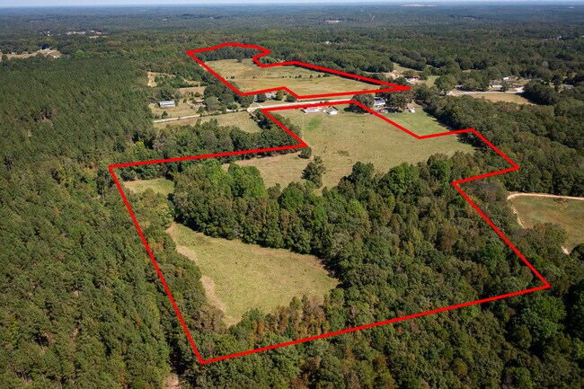
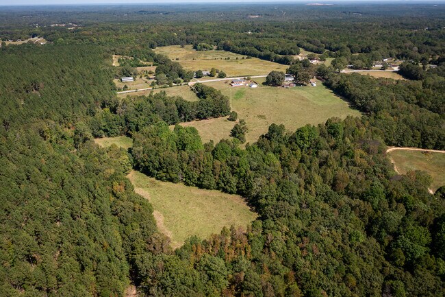
3726 Shady Grove Rd
273-00-04-012
CP S 3090/5 PP 88/736 F000 D000 TR 3 SHADY GROVE RD 11.99 AC
Agriculturalland
Anderson
X
South Carolina
45045C0550E
11.99 AC
2025
Anderson County
2024
Greenville/Spartanburg
011502
Greenville-Anderson-Greer, SC
DEMOGRAPHICS near 3726 Shady Grove Rd
1 Mile
3 Mile
5 Mile
2024 Total Population
308
1,759
8,870
2029 Population
331
1,903
9,554
Pop Growth 2024-2029
+ 7.47%
+ 8.19%
+ 7.71%
Average Age
42
42
41
2024 Total Households
122
713
3,593
HH Growth 2024-2029
+ 8.20%
+ 8.42%
+ 7.79%
Median Household Inc
$42,500
$44,610
$50,833
Avg Household Size
2.50
2.50
2.50
2024 Avg HH Vehicles
2.00
2.00
2.00
Median Home Value
$105,714
$120,479
$121,841
Median Year Built
1986
1988
1978
Nearby Places
Map Layers
Map Styles
 Street
 Aerial
- Restaurants
- Banks
- Shops
- Fitness
- Groceries
PUBLIC TRANSPORTATION
AIRPORT
Greenville Spartanburg International
DRIVE
WALK
Distance
Greenville Spartanburg International
56 min
37.7 mi
Freight Ports
North Charleston Terminal
DRIVE
WALK
Distance
North Charleston Terminal
234 min
196.4 mi
SALE & LEASE HISTORY
LISTING DATE
SALE/LEASE

Oct 10, 2023
For Sale
Nearby Properties
Address
Land Use
TOTAL SIZE
Lot Size
Zoning
Address
Land Use
TOTAL SIZE
Lot Size
Zoning
69.70 AC
UNZONED
Address
Land Use
TOTAL SIZE
Lot Size
Zoning
61.50 AC
UNZONED
Address
Land Use
TOTAL SIZE
Lot Size
Zoning
9 AC
UNZONED
Address
Land Use
TOTAL SIZE
Lot Size
Zoning
81.50 AC
Address
Land Use
TOTAL SIZE
Lot Size
Zoning
19.48 AC
Address
Land Use
TOTAL SIZE
Lot Size
Zoning
1.80 AC
UNZONED
Address
Land Use
TOTAL SIZE
Lot Size
Zoning
17.64 AC
Address
Land Use
TOTAL SIZE
Lot Size
Zoning
2,973 SF
5 AC
UNZONED
Address
Land Use
TOTAL SIZE
Lot Size
Zoning
5.50 AC
Address
Land Use
TOTAL SIZE
Lot Size
Zoning
0.77 AC
UNZONED
Address
Land Use
TOTAL SIZE
Lot Size
Zoning
Address
Land Use
TOTAL SIZE
Lot Size
Zoning
1,109 SF
26.71 AC
UNZONED
Address
Land Use
TOTAL SIZE
Lot Size
Zoning
97.75 AC
Address
Land Use
TOTAL SIZE
Lot Size
Zoning
2,496 SF
12.21 AC
UNZONED
Address
Land Use
TOTAL SIZE
Lot Size
Zoning
1,240 SF
218.61 AC
Address
Land Use
TOTAL SIZE
Lot Size
Zoning
2,130 SF
15.30 AC
UNZONED
Address
Land Use
TOTAL SIZE
Lot Size
Zoning
1,365 SF
28.90 AC
UNZONED
Address
Land Use
TOTAL SIZE
Lot Size
Zoning
1,294 SF
40.61 AC
Address
Land Use
TOTAL SIZE
Lot Size
Zoning
1,603 SF
30.37 AC
Address
Land Use
TOTAL SIZE
Lot Size
Zoning
Address
Land Use
TOTAL SIZE
Lot Size
Zoning
7.28 AC
Address
Land Use
TOTAL SIZE
Lot Size
Zoning
1,873 SF
47.90 AC
UNZONED
Address
Land Use
TOTAL SIZE
Lot Size
Zoning
Address
Land Use
TOTAL SIZE
Lot Size
Zoning
5.22 AC
Address
Land Use
TOTAL SIZE
Lot Size
Zoning
26.03 AC
Address
Land Use
TOTAL SIZE
Lot Size
Zoning
881 SF
0.88 AC
Address
Land Use
TOTAL SIZE
Lot Size
Zoning
10.82 AC
UNZONED
Address
Land Use
TOTAL SIZE
Lot Size
Zoning
6.80 AC
UNZONED
Address
Land Use
TOTAL SIZE
Lot Size
Zoning
1,680 SF
8 AC
The World's #1 Commercial Real Estate Marketplace
Connect with us
© 2026 CoStar Group
The information above has been obtained from sources believed reliable. While we do not doubt its accuracy we have not verified it and make no guarantee, warranty or representation about it. It is your responsibility to independently confirm its accuracy and completeness. Any projections, opinions, assumptions, or estimates used are for example only and do not represent the current or future performance of the property. The value of this transaction to you depends on tax and other factors which should be evaluated by your tax, financial, and legal advisors. You and your advisors should conduct a careful, independent investigation of the property to determine to your satisfaction the suitability of the property for your needs.