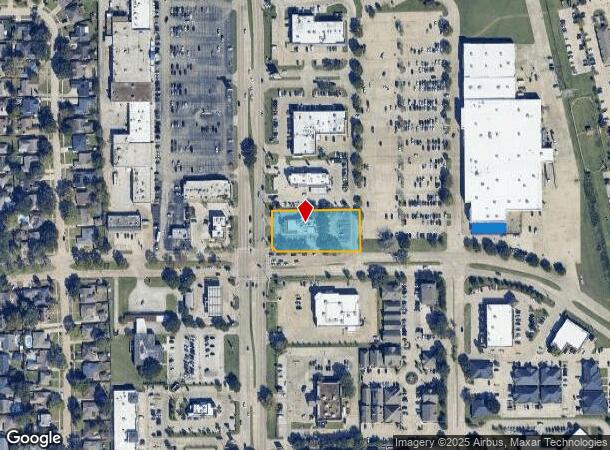
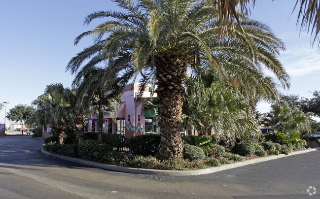
Property Record
373 S Mason Rd, Katy, TX 77450


NEARBY LISTINGS FOR SALE OR LEASE
Property Detail
373 S Mason Rd
1182450010006
Mason Park
Restaurantdrivein
RES C1 BLK 1 MASON PARK
X
Harris
48201C0595M
Texas
2024
0.96 AC
2025
Far Katy South
454600
Houston
3,335 SF
Houston-The Woodlands-Sugar Land, TX
DEMOGRAPHICS near 373 S Mason Rd
1 Mile
3 Mile
5 Mile
2024 Total Population
13,324
130,972
285,863
2029 Population
13,478
135,881
304,883
Pop Growth 2024-2029
+ 1.16%
+ 3.75%
+ 6.65%
Average Age
37
37
36
2024 Total Households
5,239
45,477
94,386
HH Growth 2024-2029
+ 1.09%
+ 3.70%
+ 6.63%
Median Household Inc
$59,858
$85,942
$91,717
Avg Household Size
2.50
2.80
3.00
2024 Avg HH Vehicles
2.00
2.00
2.00
Median Home Value
$190,644
$261,405
$271,182
Median Year Built
1988
1997
2002
Nearby Places
Map Layers
Map Styles
 Street
 Aerial
- Restaurants
- Banks
- Shops
- Fitness
- Groceries
PUBLIC TRANSPORTATION
AIRPORT
William P Hobby
DRIVE
WALK
Distance
William P Hobby
53 min
37.2 mi
George Bush Intcntl/Houston
DRIVE
WALK
Distance
George Bush Intcntl/Houston
48 min
38.5 mi
Freight Ports
Port of Houston
DRIVE
WALK
Distance
Port of Houston
47 min
34.0 mi
Nearby Properties
Address
Land Use
TOTAL SIZE
Lot Size
Zoning
Address
Land Use
TOTAL SIZE
Lot Size
Zoning
765,465 SF
63.65 AC
Address
Land Use
TOTAL SIZE
Lot Size
Zoning
614,847 SF
42 AC
Address
Land Use
TOTAL SIZE
Lot Size
Zoning
329,918 SF
19.18 AC
Address
Land Use
TOTAL SIZE
Lot Size
Zoning
523,641 SF
17.31 AC
X
Address
Land Use
TOTAL SIZE
Lot Size
Zoning
439,347 SF
13.50 AC
Address
Land Use
TOTAL SIZE
Lot Size
Zoning
380,278 SF
12.61 AC
Address
Land Use
TOTAL SIZE
Lot Size
Zoning
417,092 SF
17.58 AC
Address
Land Use
TOTAL SIZE
Lot Size
Zoning
891,129 SF
44.39 AC
Address
Land Use
TOTAL SIZE
Lot Size
Zoning
346,736 SF
14.28 AC
Address
Land Use
TOTAL SIZE
Lot Size
Zoning
352,733 SF
13.66 AC
Address
Land Use
TOTAL SIZE
Lot Size
Zoning
455,592 SF
27.53 AC
Address
Land Use
TOTAL SIZE
Lot Size
Zoning
455,592 SF
20.95 AC
Address
Land Use
TOTAL SIZE
Lot Size
Zoning
41,083 SF
23.66 AC
Address
Land Use
TOTAL SIZE
Lot Size
Zoning
339,835 SF
12.09 AC
Address
Land Use
TOTAL SIZE
Lot Size
Zoning
278,212 SF
8.15 AC
Address
Land Use
TOTAL SIZE
Lot Size
Zoning
351,758 SF
18.23 AC
Address
Land Use
TOTAL SIZE
Lot Size
Zoning
361,382 SF
14.60 AC
Address
Land Use
TOTAL SIZE
Lot Size
Zoning
375,757 SF
18.37 AC
Address
Land Use
TOTAL SIZE
Lot Size
Zoning
375,486 SF
12.36 AC
Address
Land Use
TOTAL SIZE
Lot Size
Zoning
297,040 SF
11.64 AC
Address
Land Use
TOTAL SIZE
Lot Size
Zoning
363,173 SF
13.57 AC
Address
Land Use
TOTAL SIZE
Lot Size
Zoning
327,699 SF
11.64 AC
Address
Land Use
TOTAL SIZE
Lot Size
Zoning
343,605 SF
11.90 AC
Address
Land Use
TOTAL SIZE
Lot Size
Zoning
168,051 SF
12.68 AC
Address
Land Use
TOTAL SIZE
Lot Size
Zoning
12.50 AC
Address
Land Use
TOTAL SIZE
Lot Size
Zoning
348,199 SF
16.69 AC
Address
Land Use
TOTAL SIZE
Lot Size
Zoning
440,214 SF
23.66 AC
Address
Land Use
TOTAL SIZE
Lot Size
Zoning
261,803 SF
12.51 AC
Address
Land Use
TOTAL SIZE
Lot Size
Zoning
319,717 SF
10.45 AC
Address
Land Use
TOTAL SIZE
Lot Size
Zoning
319,341 SF
14.88 AC
The World's #1 Commercial Real Estate Marketplace
Connect with us
© 2025 CoStar Group
The information above has been obtained from sources believed reliable. While we do not doubt its accuracy we have not verified it and make no guarantee, warranty or representation about it. It is your responsibility to independently confirm its accuracy and completeness. Any projections, opinions, assumptions, or estimates used are for example only and do not represent the current or future performance of the property. The value of this transaction to you depends on tax and other factors which should be evaluated by your tax, financial, and legal advisors. You and your advisors should conduct a careful, independent investigation of the property to determine to your satisfaction the suitability of the property for your needs.