Property Record
3730 Herr Rd, Sylvania, OH 43560


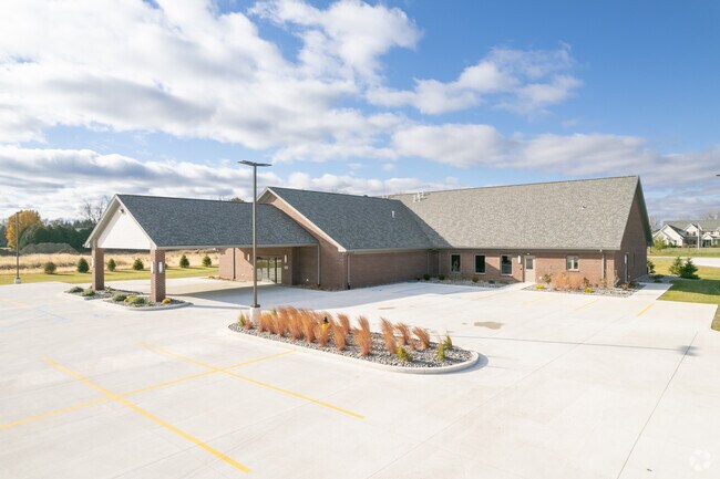
Property Detail
3730 Herr Rd
78-29323
6 9 19 NW 1/4 SE 1/4 S 320 FT N 421.11 FT SUBJ TO LEGAL HWYS
Religious
LUCAS
20-A3
Ohio
AE The base floodplain where base flood elevations are provided. AE Zones are now used on new format FIRMs instead of A1-A30 Zones.
6.54 AC
2025
West/Sylvania
2025
Toledo
009204
Toledo, OH
10,094 SF
NEARBY LISTINGS FOR SALE OR LEASE
-
-
View all Sylvania listings for sale on LoopNet.com
DEMOGRAPHICS near 3730 Herr Rd
1 mile
3 mile
5 mile
2025 Total Population
1,204
30,239
71,929
2030 Population
1,219
29,909
70,981
Pop Growth 2025-2030
+ 1.25%
(1.09%)
(1.32%)
Average Age
41
42
42
2025 Total Households
445
11,326
29,505
HH Growth 2025-2030
+ 1.35%
(1.09%)
(1.26%)
Median Household Inc
$156,686
$137,191
$94,920
Avg Household Size
2.70
2.60
2.40
2025 Avg HH Vehicles
2.00
2.00
2.00
Median Home Value
$384,506
$326,247
$268,593
Median Year Built
2003
1988
1982
Nearby Places
Map Layers
Map Styles
 Street
 Aerial
Layers
 Traffic
 Biking
Places
Listings with unknown addresses are not visible on the map
- Restaurants
- Banks
- Shops
- Fitness
- Groceries
PUBLIC TRANSPORTATION
AIRPORT
Eugene F Kranz Toledo Express
Drive
Walk
Distance
Eugene F Kranz Toledo Express
25 min
12.8 mi
Freight Ports
Port of Toledo
Drive
Walk
Distance
Port of Toledo
34 min
19.8 mi
Nearby Properties
Address
Land Use
TOTAL SIZE
Lot Size
Zoning
Address
Land Use
TOTAL SIZE
Lot Size
Zoning
209,351 SF
49.06 AC
31-R1
Address
Land Use
TOTAL SIZE
Lot Size
Zoning
90,056 SF
10.17 AC
20-C2
Address
Land Use
TOTAL SIZE
Lot Size
Zoning
78,678 SF
10.20 AC
31-R1
Address
Land Use
TOTAL SIZE
Lot Size
Zoning
89,031 SF
15.83 AC
31-M2
Address
Land Use
TOTAL SIZE
Lot Size
Zoning
101,635 SF
34.34 AC
20-S1
Address
Land Use
TOTAL SIZE
Lot Size
Zoning
130,387 SF
8.50 AC
20-R5
Address
Land Use
TOTAL SIZE
Lot Size
Zoning
217,992 SF
39.78 AC
20-C2
Address
Land Use
TOTAL SIZE
Lot Size
Zoning
137,081 SF
12 AC
20-C2
Address
Land Use
TOTAL SIZE
Lot Size
Zoning
119,804 SF
5.02 AC
31-R4
Address
Land Use
TOTAL SIZE
Lot Size
Zoning
102,800 SF
23.01 AC
20-R4
Address
Land Use
TOTAL SIZE
Lot Size
Zoning
70,550 SF
8.25 AC
31-B1
Address
Land Use
TOTAL SIZE
Lot Size
Zoning
36,153 SF
4.43 AC
20-C2
Address
Land Use
TOTAL SIZE
Lot Size
Zoning
74,418 SF
33.17 AC
20-A3
Address
Land Use
TOTAL SIZE
Lot Size
Zoning
130,168 SF
12 AC
31-R2
Address
Land Use
TOTAL SIZE
Lot Size
Zoning
43,755 SF
9.02 AC
20-R4PUD
Address
Land Use
TOTAL SIZE
Lot Size
Zoning
70,483 SF
8.53 AC
31-R1
Address
Land Use
TOTAL SIZE
Lot Size
Zoning
122,154 SF
10.62 AC
20-MX
Address
Land Use
TOTAL SIZE
Lot Size
Zoning
77,161 SF
19.71 AC
34-AR
Address
Land Use
TOTAL SIZE
Lot Size
Zoning
65,182 SF
8.40 AC
19-PO
Address
Land Use
TOTAL SIZE
Lot Size
Zoning
121,446 SF
8.87 AC
20-MX
Address
Land Use
TOTAL SIZE
Lot Size
Zoning
50,394 SF
4.64 AC
20-A3
Address
Land Use
TOTAL SIZE
Lot Size
Zoning
50,394 SF
3.79 AC
20-MX
Address
Land Use
TOTAL SIZE
Lot Size
Zoning
58,149 SF
6.90 AC
20-R4PUD
Address
Land Use
TOTAL SIZE
Lot Size
Zoning
79,516 SF
19.85 AC
31-R1
Address
Land Use
TOTAL SIZE
Lot Size
Zoning
46,656 SF
5.60 AC
20-C2
Address
Land Use
TOTAL SIZE
Lot Size
Zoning
79,149 SF
4.35 AC
31-R4
Address
Land Use
TOTAL SIZE
Lot Size
Zoning
92,731 SF
7 AC
31-B2
Address
Land Use
TOTAL SIZE
Lot Size
Zoning
95,467 SF
7.65 AC
31-R3
Address
Land Use
TOTAL SIZE
Lot Size
Zoning
80,351 SF
44.65 AC
20-A3
Address
Land Use
TOTAL SIZE
Lot Size
Zoning
92,576 SF
8.42 AC
19-R3
The World's #1 Commercial Real Estate Marketplace
Connect with us
© 2026 CoStar Group
The information above has been obtained from sources believed reliable. While we do not doubt its accuracy we have not verified it and make no guarantee, warranty or representation about it. It is your responsibility to independently confirm its accuracy and completeness. Any projections, opinions, assumptions, or estimates used are for example only and do not represent the current or future performance of the property. The value of this transaction to you depends on tax and other factors which should be evaluated by your tax, financial, and legal advisors. You and your advisors should conduct a careful, independent investigation of the property to determine to your satisfaction the suitability of the property for your needs.