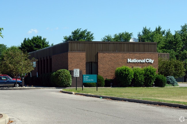
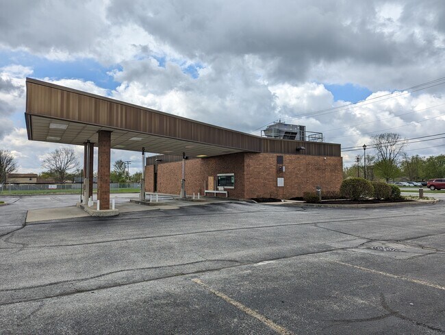
Property Record
3730 Maplecrest Rd, Fort Wayne, IN 46815

NEARBY LISTINGS FOR SALE OR LEASE
Property Detail
3730 Maplecrest Rd
02-08-27-301-001.000-072
Blackhawk
Financialbuilding
N 1267.5 OF W 2156.4FT SW1/4 EX TRACTS & EX BLACKHAWK FARM SEC II & EX PT TO COUNTY & EX PT TO RD SEC 27
X
Allen
18003C0306G
Indiana
2023
0.62 AC
2024
North Fort Wayne
010809
Fort Wayne
2,686 SF
Fort Wayne, IN
DEMOGRAPHICS near 3730 Maplecrest Rd
1 Mile
3 Mile
5 Mile
2024 Total Population
10,988
65,986
147,270
2029 Population
11,296
68,201
153,279
Pop Growth 2024-2029
+ 2.80%
+ 3.36%
+ 4.08%
Average Age
39
40
38
2024 Total Households
4,190
27,520
60,419
HH Growth 2024-2029
+ 2.84%
+ 3.39%
+ 4.20%
Median Household Inc
$68,930
$62,770
$57,177
Avg Household Size
2.60
2.30
2.30
2024 Avg HH Vehicles
2.00
2.00
2.00
Median Home Value
$153,149
$160,731
$153,851
Median Year Built
1971
1975
1972
Nearby Places
Map Layers
Map Styles
 Street
 Aerial
- Restaurants
- Banks
- Shops
- Fitness
- Groceries
PUBLIC TRANSPORTATION
AIRPORT
Fort Wayne International
DRIVE
WALK
Distance
Fort Wayne International
32 min
16.7 mi
Freight Ports
Port of Toledo
DRIVE
WALK
Distance
Port of Toledo
134 min
100.4 mi
SALE & LEASE HISTORY
LISTING DATE
SALE/LEASE

Jun 17, 2021
For Sale
Dec 14, 2023
For Sale
Nearby Properties
Address
Land Use
TOTAL SIZE
Lot Size
Zoning
Address
Land Use
TOTAL SIZE
Lot Size
Zoning
921,633 SF
18.04 AC
Address
Land Use
TOTAL SIZE
Lot Size
Zoning
855,487 SF
102.83 AC
Address
Land Use
TOTAL SIZE
Lot Size
Zoning
702,400 SF
40.69 AC
Address
Land Use
TOTAL SIZE
Lot Size
Zoning
129,080 SF
15.77 AC
Address
Land Use
TOTAL SIZE
Lot Size
Zoning
68,817 SF
14.26 AC
Address
Land Use
TOTAL SIZE
Lot Size
Zoning
298,087 SF
24.54 AC
Address
Land Use
TOTAL SIZE
Lot Size
Zoning
215,768 SF
23.56 AC
Address
Land Use
TOTAL SIZE
Lot Size
Zoning
75,690 SF
26.84 AC
Address
Land Use
TOTAL SIZE
Lot Size
Zoning
25,272 SF
2.58 AC
Address
Land Use
TOTAL SIZE
Lot Size
Zoning
32,189 SF
9.64 AC
Address
Land Use
TOTAL SIZE
Lot Size
Zoning
295,073 SF
26.25 AC
Address
Land Use
TOTAL SIZE
Lot Size
Zoning
206,618 SF
21.20 AC
Address
Land Use
TOTAL SIZE
Lot Size
Zoning
210,230 SF
35.30 AC
Address
Land Use
TOTAL SIZE
Lot Size
Zoning
58,913 SF
22.64 AC
Address
Land Use
TOTAL SIZE
Lot Size
Zoning
250,021 SF
2.25 AC
Address
Land Use
TOTAL SIZE
Lot Size
Zoning
169,740 SF
30.62 AC
Address
Land Use
TOTAL SIZE
Lot Size
Zoning
154,746 SF
8.75 AC
Address
Land Use
TOTAL SIZE
Lot Size
Zoning
126,957 SF
21.27 AC
Address
Land Use
TOTAL SIZE
Lot Size
Zoning
132,340 SF
21.46 AC
Address
Land Use
TOTAL SIZE
Lot Size
Zoning
255,864 SF
10.70 AC
Address
Land Use
TOTAL SIZE
Lot Size
Zoning
62,666 SF
21.37 AC
Address
Land Use
TOTAL SIZE
Lot Size
Zoning
72,240 SF
9.41 AC
Address
Land Use
TOTAL SIZE
Lot Size
Zoning
19,872 SF
13.38 AC
Address
Land Use
TOTAL SIZE
Lot Size
Zoning
50,072 SF
8.28 AC
Address
Land Use
TOTAL SIZE
Lot Size
Zoning
188,270 SF
22.50 AC
Address
Land Use
TOTAL SIZE
Lot Size
Zoning
70,312 SF
25.22 AC
Address
Land Use
TOTAL SIZE
Lot Size
Zoning
94,015 SF
9.45 AC
Address
Land Use
TOTAL SIZE
Lot Size
Zoning
24,612 SF
5.83 AC
Address
Land Use
TOTAL SIZE
Lot Size
Zoning
79,707 SF
11.53 AC
Address
Land Use
TOTAL SIZE
Lot Size
Zoning
119,799 SF
16.42 AC
The World's #1 Commercial Real Estate Marketplace
Connect with us
© 2025 CoStar Group
The information above has been obtained from sources believed reliable. While we do not doubt its accuracy we have not verified it and make no guarantee, warranty or representation about it. It is your responsibility to independently confirm its accuracy and completeness. Any projections, opinions, assumptions, or estimates used are for example only and do not represent the current or future performance of the property. The value of this transaction to you depends on tax and other factors which should be evaluated by your tax, financial, and legal advisors. You and your advisors should conduct a careful, independent investigation of the property to determine to your satisfaction the suitability of the property for your needs.