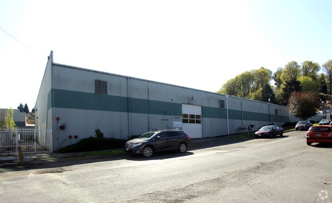
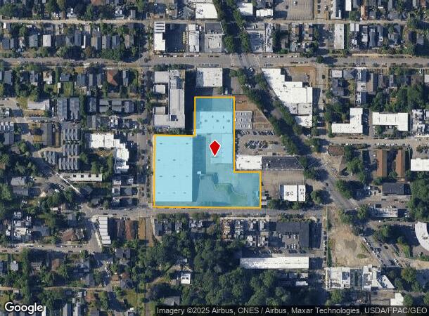
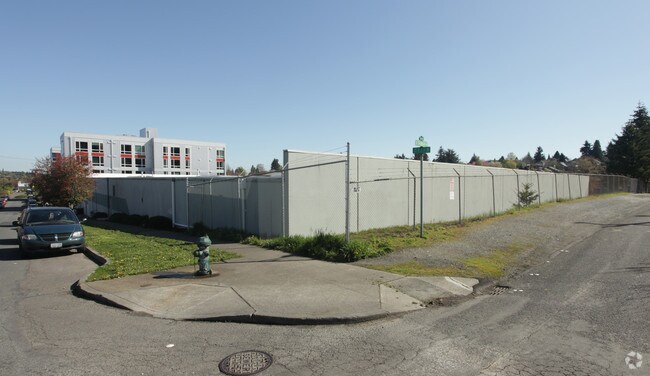
Property Record
3730 S Dawson St, Seattle, WA 98118

NEARBY LISTINGS FOR SALE OR LEASE
Property Detail
3730 S Dawson St
Seattle-Tacoma-Bellevue, WA
Morningside Acre Tracts
564960-0170
MORNING SIDE ACRE TRACTS PCL C SEATTLE LBA #3010500 REC# 20100113900001 SD LBA BEING POR TRS 15 & 29 & 30 TGW ALL TRS 16 THRU 18
Industrialgeneral
King
X
Washington
53033C0645G
15
2025
2.67 AC
2024
Rainier/Beacon Hill
011101
Seattle/Puget Sound
68,156 SF
DEMOGRAPHICS near 3730 S Dawson St
1 Mile
3 Mile
5 Mile
2024 Total Population
27,591
109,463
391,021
2029 Population
27,860
110,805
397,316
Pop Growth 2024-2029
+ 0.97%
+ 1.23%
+ 1.61%
Average Age
40
40
40
2024 Total Households
10,328
41,404
177,439
HH Growth 2024-2029
+ 0.91%
+ 1.17%
+ 1.75%
Median Household Inc
$116,751
$107,190
$104,577
Avg Household Size
2.50
2.50
2.10
2024 Avg HH Vehicles
2.00
2.00
1.00
Median Home Value
$789,735
$823,307
$820,576
Median Year Built
1965
1966
1980
Nearby Places
Map Layers
Map Styles
 Street
 Aerial
- Restaurants
- Banks
- Shops
- Fitness
- Groceries
PUBLIC TRANSPORTATION
TRANSIT/SUBWAY
ST Light Rail & Columbia City Station (SB) (LINK to Sea-Tac - Central Puget Sound Regional Transit Authority Rail (Link Light Rail/Sounder))
DRIVE
WALK
Distance
ST Light Rail & Columbia City Station (SB) (LINK to Sea-Tac - Central Puget Sound Regional Transit Authority Rail (Link Light Rail/Sounder))
3 min
11 min
0.6 mi
ST Light Rail & Columbia City Station (NB) (LINK to Sea-Tac - Central Puget Sound Regional Transit Authority Rail (Link Light Rail/Sounder))
DRIVE
WALK
Distance
ST Light Rail & Columbia City Station (NB) (LINK to Sea-Tac - Central Puget Sound Regional Transit Authority Rail (Link Light Rail/Sounder))
3 min
13 min
0.6 mi
Columbia City (Central Link - Central Puget Sound Regional Transit Authority Rail (Link Light Rail/Sounder))
DRIVE
WALK
Distance
Columbia City (Central Link - Central Puget Sound Regional Transit Authority Rail (Link Light Rail/Sounder))
3 min
13 min
0.6 mi
COMMUTER RAIL
King Street (Seattle) Station (Sounder South Line - Central Puget Sound Regional Transit Authority Rail (Link Light Rail/Sounder))
DRIVE
WALK
Distance
King Street (Seattle) Station (Sounder South Line - Central Puget Sound Regional Transit Authority Rail (Link Light Rail/Sounder))
13 min
4.0 mi
Tukwila Station (Sounder South Line - Central Puget Sound Regional Transit Authority Rail (Link Light Rail/Sounder))
DRIVE
WALK
Distance
Tukwila Station (Sounder South Line - Central Puget Sound Regional Transit Authority Rail (Link Light Rail/Sounder))
21 min
9.0 mi
AIRPORT
Seattle-Tacoma International
DRIVE
WALK
Distance
Seattle-Tacoma International
25 min
10.5 mi
Seattle Paine Field International
DRIVE
WALK
Distance
Seattle Paine Field International
45 min
28.6 mi
Freight Ports
Port of Seattle
DRIVE
WALK
Distance
Port of Seattle
14 min
4.8 mi
Nearby Properties
Address
Land Use
TOTAL SIZE
Lot Size
Zoning
Address
Land Use
TOTAL SIZE
Lot Size
Zoning
30,290 SF
564.80 AC
MML U/85
Address
Land Use
TOTAL SIZE
Lot Size
Zoning
2,800 SF
210.85 AC
NR1
Address
Land Use
TOTAL SIZE
Lot Size
Zoning
263,600 SF
5.38 AC
II U/160
Address
Land Use
TOTAL SIZE
Lot Size
Zoning
56,474 SF
99.48 AC
MML U/85
Address
Land Use
TOTAL SIZE
Lot Size
Zoning
1,134 SF
53.17 AC
MIC/H
Address
Land Use
TOTAL SIZE
Lot Size
Zoning
533,910 SF
15.04 AC
MML U/85
Address
Land Use
TOTAL SIZE
Lot Size
Zoning
162,157 SF
24.06 AC
MML U/85
Address
Land Use
TOTAL SIZE
Lot Size
Zoning
147,878 SF
13.67 AC
MML U/85
Address
Land Use
TOTAL SIZE
Lot Size
Zoning
218,805 SF
51.21 AC
MIO-105-LR
Address
Land Use
TOTAL SIZE
Lot Size
Zoning
141,643 SF
11.44 AC
MIC/H
Address
Land Use
TOTAL SIZE
Lot Size
Zoning
525,975 SF
37.45 AC
MML U/85
Address
Land Use
TOTAL SIZE
Lot Size
Zoning
424,367 SF
32.99 AC
MML U/85
Address
Land Use
TOTAL SIZE
Lot Size
Zoning
64 SF
36.70 AC
MML U/85
Address
Land Use
TOTAL SIZE
Lot Size
Zoning
102,075 SF
10.06 AC
MML U/85
Address
Land Use
TOTAL SIZE
Lot Size
Zoning
164,256 SF
8.47 AC
LR2 (M)
Address
Land Use
TOTAL SIZE
Lot Size
Zoning
326,751 SF
10.92 AC
MML U/85
Address
Land Use
TOTAL SIZE
Lot Size
Zoning
179,161 SF
19.03 AC
MML U/85
Address
Land Use
TOTAL SIZE
Lot Size
Zoning
27,400 SF
0.63 AC
NC3-75 (M)
Address
Land Use
TOTAL SIZE
Lot Size
Zoning
411,584 SF
18.37 AC
MML U/85
Address
Land Use
TOTAL SIZE
Lot Size
Zoning
1,258 SF
0.09 AC
NC3-75 (M)
Address
Land Use
TOTAL SIZE
Lot Size
Zoning
323,916 SF
10.33 AC
MML U/85
Address
Land Use
TOTAL SIZE
Lot Size
Zoning
169,110 SF
29.99 AC
MIC/H
Address
Land Use
TOTAL SIZE
Lot Size
Zoning
8,110 SF
131.10 AC
NR3
Address
Land Use
TOTAL SIZE
Lot Size
Zoning
241,186 SF
25.51 AC
MIC/H
Address
Land Use
TOTAL SIZE
Lot Size
Zoning
166,212 SF
1.57 AC
NC2P-55 (M
Address
Land Use
TOTAL SIZE
Lot Size
Zoning
31,737 SF
9.55 AC
RSL (M)
Address
Land Use
TOTAL SIZE
Lot Size
Zoning
195,200 SF
4.68 AC
LR3 (M)
Address
Land Use
TOTAL SIZE
Lot Size
Zoning
328,775 SF
0.76 AC
MML U/85
Address
Land Use
TOTAL SIZE
Lot Size
Zoning
327,983 SF
6.91 AC
II U/160
Address
Land Use
TOTAL SIZE
Lot Size
Zoning
16,800 SF
10.13 AC
C2-75 (M)
The World's #1 Commercial Real Estate Marketplace
Connect with us
© 2025 CoStar Group
The information above has been obtained from sources believed reliable. While we do not doubt its accuracy we have not verified it and make no guarantee, warranty or representation about it. It is your responsibility to independently confirm its accuracy and completeness. Any projections, opinions, assumptions, or estimates used are for example only and do not represent the current or future performance of the property. The value of this transaction to you depends on tax and other factors which should be evaluated by your tax, financial, and legal advisors. You and your advisors should conduct a careful, independent investigation of the property to determine to your satisfaction the suitability of the property for your needs.