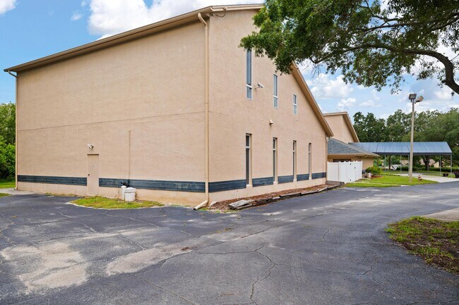
Property Record
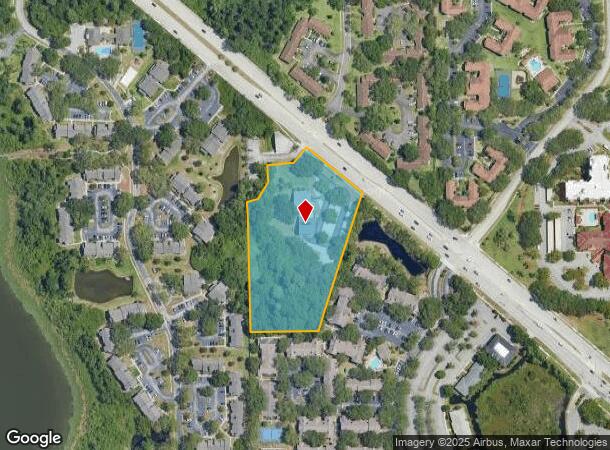
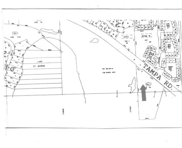
3730 Tampa Rd, Palm Harbor, FL 34684
Current Lease Availabilities
NEARBY LISTINGS FOR SALE OR LEASE
Property Detail
3730 Tampa Rd
Tampa-St. Petersburg-Clearwater, FL
La Mirage Office Complex
08-28-16-47437-000-0010
LA MIRAGE OFFICE COMPLEX LOT 1
Storebuilding
Pinellas
X
Florida
12103C0079H
1
2024
4.15 AC
2025
North Pinellas
027317
Tampa/St Petersburg
7,579 SF
DEMOGRAPHICS near 3730 Tampa Rd
1 Mile
3 Mile
5 Mile
2024 Total Population
12,687
80,149
176,977
2029 Population
12,597
79,552
176,597
Pop Growth 2024-2029
(0.71%)
(0.74%)
(0.21%)
Average Age
46
48
48
2024 Total Households
6,128
35,467
80,574
HH Growth 2024-2029
(1.00%)
(0.90%)
(0.35%)
Median Household Inc
$62,883
$72,728
$67,538
Avg Household Size
2.00
2.20
2.10
2024 Avg HH Vehicles
1.00
2.00
2.00
Median Home Value
$270,803
$321,626
$320,134
Median Year Built
1985
1984
1983
Nearby Places
- Restaurants
- Banks
- Shops
- Fitness
- Groceries
PUBLIC TRANSPORTATION
AIRPORT
St Pete-Clearwater International
DRIVE
WALK
Distance
St Pete-Clearwater International
20 min
11.9 mi
Tampa International
DRIVE
WALK
Distance
Tampa International
28 min
15.5 mi
Freight Ports
Port of Tampa Bay
DRIVE
WALK
Distance
Port of Tampa Bay
42 min
24.0 mi
Nearby Properties
Address
Land Use
TOTAL SIZE
Lot Size
Zoning
Address
Land Use
TOTAL SIZE
Lot Size
Zoning
661,982 SF
19.26 AC
Address
Land Use
TOTAL SIZE
Lot Size
Zoning
462,206 SF
30.26 AC
RPD5
Address
Land Use
TOTAL SIZE
Lot Size
Zoning
417,535 SF
42.47 AC
Address
Land Use
TOTAL SIZE
Lot Size
Zoning
326,008 SF
53.12 AC
Address
Land Use
TOTAL SIZE
Lot Size
Zoning
302,915 SF
55.33 AC
RPD75
Address
Land Use
TOTAL SIZE
Lot Size
Zoning
286,650 SF
23.36 AC
RPD5
Address
Land Use
TOTAL SIZE
Lot Size
Zoning
311,117 SF
16.96 AC
Address
Land Use
TOTAL SIZE
Lot Size
Zoning
241,867 SF
19.54 AC
Address
Land Use
TOTAL SIZE
Lot Size
Zoning
242,708 SF
26.17 AC
RPD10
Address
Land Use
TOTAL SIZE
Lot Size
Zoning
233,620 SF
14.13 AC
RPD5
Address
Land Use
TOTAL SIZE
Lot Size
Zoning
304,142 SF
12.19 AC
RPD5
Address
Land Use
TOTAL SIZE
Lot Size
Zoning
6,066 SF
284.52 AC
AE
Address
Land Use
TOTAL SIZE
Lot Size
Zoning
239,480 SF
18.89 AC
RPD5
Address
Land Use
TOTAL SIZE
Lot Size
Zoning
258,403 SF
10.62 AC
RPD5
Address
Land Use
TOTAL SIZE
Lot Size
Zoning
188,845 SF
33.69 AC
RPD5
Address
Land Use
TOTAL SIZE
Lot Size
Zoning
161,404 SF
18.48 AC
CP2
Address
Land Use
TOTAL SIZE
Lot Size
Zoning
294,022 SF
15.75 AC
RPD5
Address
Land Use
TOTAL SIZE
Lot Size
Zoning
199,825 SF
22.75 AC
R2
Address
Land Use
TOTAL SIZE
Lot Size
Zoning
151,398 SF
15.55 AC
CP1
Address
Land Use
TOTAL SIZE
Lot Size
Zoning
311,414 SF
15.59 AC
RPD75
Address
Land Use
TOTAL SIZE
Lot Size
Zoning
145,000 SF
1.26 AC
Address
Land Use
TOTAL SIZE
Lot Size
Zoning
116,975 SF
9 AC
AE
Address
Land Use
TOTAL SIZE
Lot Size
Zoning
220,103 SF
28.40 AC
Address
Land Use
TOTAL SIZE
Lot Size
Zoning
14,334 SF
117.55 AC
Address
Land Use
TOTAL SIZE
Lot Size
Zoning
115,788 SF
14.84 AC
C2
Address
Land Use
TOTAL SIZE
Lot Size
Zoning
446,974 SF
11.32 AC
AE
Address
Land Use
TOTAL SIZE
Lot Size
Zoning
277,078 SF
35.38 AC
Address
Land Use
TOTAL SIZE
Lot Size
Zoning
249,928 SF
79.57 AC
M1
Address
Land Use
TOTAL SIZE
Lot Size
Zoning
94,029 SF
19.67 AC
RPD75
Address
Land Use
TOTAL SIZE
Lot Size
Zoning
92,511 SF
18.39 AC
RPD75
The World's #1 Commercial Real Estate Marketplace
Connect with us
© 2025 CoStar Group
The information above has been obtained from sources believed reliable. While we do not doubt its accuracy we have not verified it and make no guarantee, warranty or representation about it. It is your responsibility to independently confirm its accuracy and completeness. Any projections, opinions, assumptions, or estimates used are for example only and do not represent the current or future performance of the property. The value of this transaction to you depends on tax and other factors which should be evaluated by your tax, financial, and legal advisors. You and your advisors should conduct a careful, independent investigation of the property to determine to your satisfaction the suitability of the property for your needs.