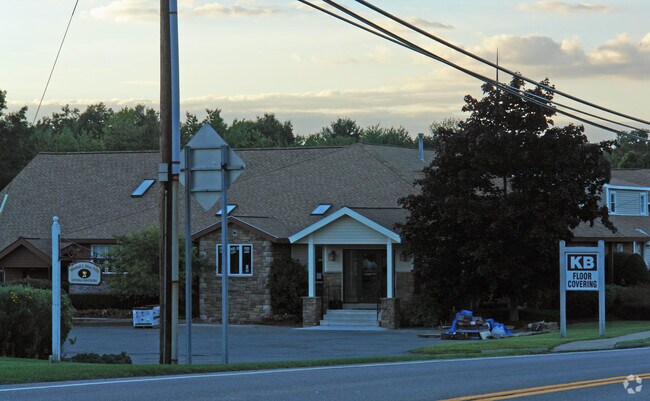
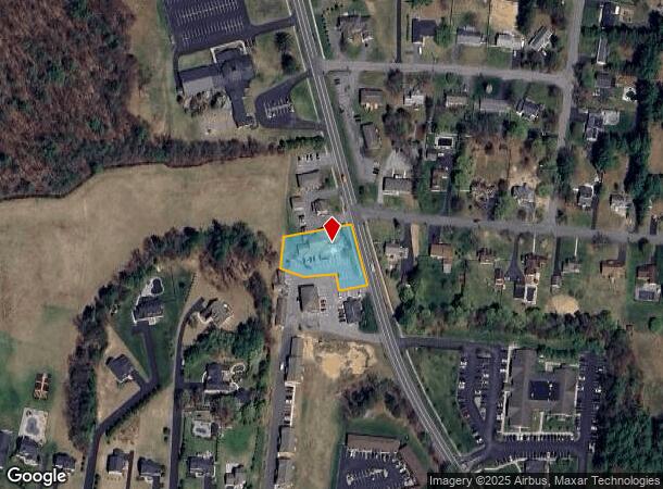
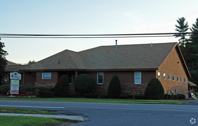
Property Record
3732 Carman Rd, Schenectady, NY 12303
NEARBY LISTINGS FOR SALE OR LEASE
-
-
View all Schenectady listings for sale on LoopNet.com
Property Detail
3732 Carman Rd
013089-027-019-0001-002-004-0000
Albany
Professionalbldglegalinsurancerealestateetc
New York
X
2.004
36001C0152D
0.86 AC
2025
W Outer Albany County
2024
Albany/Schenectady/Troy
014606
Albany-Schenectady-Troy, NY
5,710 SF
DEMOGRAPHICS near 3732 Carman Rd
1 Mile
3 Mile
5 Mile
2024 Total Population
5,795
19,798
93,587
2029 Population
5,779
19,847
95,819
Pop Growth 2024-2029
(0.28%)
+ 0.25%
+ 2.38%
Average Age
41
43
42
2024 Total Households
2,163
7,995
38,816
HH Growth 2024-2029
(0.18%)
+ 0.44%
+ 2.53%
Median Household Inc
$128,049
$103,789
$78,808
Avg Household Size
2.60
2.40
2.30
2024 Avg HH Vehicles
2.00
2.00
2.00
Median Home Value
$361,169
$308,663
$221,928
Median Year Built
1982
1977
1964
Nearby Places
Map Layers
Map Styles
 Street
 Aerial
- Restaurants
- Banks
- Shops
- Fitness
- Groceries
PUBLIC TRANSPORTATION
COMMUTER RAIL
DRIVE
WALK
Distance
15 min
8.5 mi
AIRPORT
Albany International
DRIVE
WALK
Distance
Albany International
25 min
13.4 mi
Freight Ports
Albany, NY Port
DRIVE
WALK
Distance
Albany, NY Port
26 min
16.2 mi
Nearby Properties
Address
Land Use
TOTAL SIZE
Lot Size
Zoning
Address
Land Use
TOTAL SIZE
Lot Size
Zoning
47,424 SF
37.60 AC
MR
Address
Land Use
TOTAL SIZE
Lot Size
Zoning
98.20 AC
LC
Address
Land Use
TOTAL SIZE
Lot Size
Zoning
353,075 SF
69.50 AC
R15
Address
Land Use
TOTAL SIZE
Lot Size
Zoning
172,800 SF
209.63 AC
IN
Address
Land Use
TOTAL SIZE
Lot Size
Zoning
172,800 SF
272.81 AC
IN
Address
Land Use
TOTAL SIZE
Lot Size
Zoning
9,000 SF
10.32 AC
GB
Address
Land Use
TOTAL SIZE
Lot Size
Zoning
19,968 SF
12 AC
MR
Address
Land Use
TOTAL SIZE
Lot Size
Zoning
78,326 SF
27.47 AC
R40
Address
Land Use
TOTAL SIZE
Lot Size
Zoning
14,436 SF
13.20 AC
MR
Address
Land Use
TOTAL SIZE
Lot Size
Zoning
45 AC
LC
Address
Land Use
TOTAL SIZE
Lot Size
Zoning
Address
Land Use
TOTAL SIZE
Lot Size
Zoning
86,049 SF
17.10 AC
RO30
Address
Land Use
TOTAL SIZE
Lot Size
Zoning
16,232 SF
285.90 AC
RO40
Address
Land Use
TOTAL SIZE
Lot Size
Zoning
89,640 SF
6 AC
MR
Address
Land Use
TOTAL SIZE
Lot Size
Zoning
7,856 SF
14.30 AC
MR
Address
Land Use
TOTAL SIZE
Lot Size
Zoning
20,630 SF
12.99 AC
MR*
Address
Land Use
TOTAL SIZE
Lot Size
Zoning
97,440 SF
8.15 AC
B-2
Address
Land Use
TOTAL SIZE
Lot Size
Zoning
68,000 SF
11.20 AC
TH
Address
Land Use
TOTAL SIZE
Lot Size
Zoning
6,889 SF
284.30 AC
F
Address
Land Use
TOTAL SIZE
Lot Size
Zoning
7,148 SF
7.20 AC
PUD
Address
Land Use
TOTAL SIZE
Lot Size
Zoning
134,624 SF
26.23 AC
CON
Address
Land Use
TOTAL SIZE
Lot Size
Zoning
61,006 SF
8.10 AC
R15
Address
Land Use
TOTAL SIZE
Lot Size
Zoning
3,200 SF
231.30 AC
RA3
Address
Land Use
TOTAL SIZE
Lot Size
Zoning
47,951 SF
8.10 AC
GB
Address
Land Use
TOTAL SIZE
Lot Size
Zoning
87,983 SF
42.54 AC
R15
Address
Land Use
TOTAL SIZE
Lot Size
Zoning
51,779 SF
17.50 AC
R-1
Address
Land Use
TOTAL SIZE
Lot Size
Zoning
80,400 SF
51.97 AC
R-1
Address
Land Use
TOTAL SIZE
Lot Size
Zoning
33,176 SF
3.29 AC
R15
Address
Land Use
TOTAL SIZE
Lot Size
Zoning
22,080 SF
10.62 AC
R-3
Address
Land Use
TOTAL SIZE
Lot Size
Zoning
56,592 SF
29.50 AC
R20
The World's #1 Commercial Real Estate Marketplace
Connect with us
© 2025 CoStar Group
The information above has been obtained from sources believed reliable. While we do not doubt its accuracy we have not verified it and make no guarantee, warranty or representation about it. It is your responsibility to independently confirm its accuracy and completeness. Any projections, opinions, assumptions, or estimates used are for example only and do not represent the current or future performance of the property. The value of this transaction to you depends on tax and other factors which should be evaluated by your tax, financial, and legal advisors. You and your advisors should conduct a careful, independent investigation of the property to determine to your satisfaction the suitability of the property for your needs.