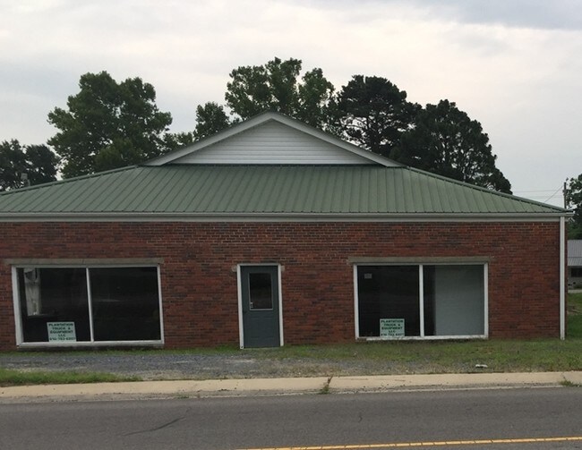
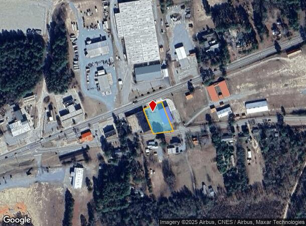
Property Record
3733 Us 15 501 Hwy, Carthage, NC 28327
NEARBY LISTINGS FOR SALE OR LEASE
Property Detail
3733 Us 15 501 Hwy
8588-18-30-2341
Fairground Prop
Publicstorage
#13-17 60-64
X
Moore
3710858800J
North Carolina
2024
0.53 AC
2024
North Carolina Southeast Area
950402
Other Market Areas
3,100 SF
Pinehurst-Southern Pines, NC
DEMOGRAPHICS near 3733 Us 15 501 Hwy
1 Mile
3 Mile
5 Mile
2024 Total Population
451
4,257
8,257
2029 Population
514
4,882
9,436
Pop Growth 2024-2029
+ 13.97%
+ 14.68%
+ 14.28%
Average Age
42
41
41
2024 Total Households
186
1,677
3,209
HH Growth 2024-2029
+ 13.98%
+ 14.97%
+ 14.55%
Median Household Inc
$52,608
$55,670
$60,554
Avg Household Size
2.30
2.40
2.50
2024 Avg HH Vehicles
2.00
2.00
2.00
Median Home Value
$151,470
$164,203
$186,199
Median Year Built
1993
1994
1992
Nearby Places
- Restaurants
- Banks
- Shops
- Fitness
- Groceries
SALE & LEASE HISTORY
LISTING DATE
SALE/LEASE

Sep 23, 2016
For Sale
Nearby Properties
Address
Land Use
TOTAL SIZE
Lot Size
Zoning
Address
Land Use
TOTAL SIZE
Lot Size
Zoning
74,014 SF
20.80 AC
MULTI
Address
Land Use
TOTAL SIZE
Lot Size
Zoning
0.13 AC
CDB
Address
Land Use
TOTAL SIZE
Lot Size
Zoning
83,896 SF
4 AC
RA40
Address
Land Use
TOTAL SIZE
Lot Size
Zoning
10,366 SF
56.57 AC
RA40
Address
Land Use
TOTAL SIZE
Lot Size
Zoning
14,632 SF
0.76 AC
CDB
Address
Land Use
TOTAL SIZE
Lot Size
Zoning
33,688 SF
6.83 AC
TBD
Address
Land Use
TOTAL SIZE
Lot Size
Zoning
17.78 AC
Address
Land Use
TOTAL SIZE
Lot Size
Zoning
11,900 SF
18.40 AC
RA40
Address
Land Use
TOTAL SIZE
Lot Size
Zoning
31,394 SF
8 AC
TBD
Address
Land Use
TOTAL SIZE
Lot Size
Zoning
15,808 SF
3.06 AC
Address
Land Use
TOTAL SIZE
Lot Size
Zoning
4,200 SF
23.05 AC
B2
Address
Land Use
TOTAL SIZE
Lot Size
Zoning
6,380 SF
10.44 AC
RA
Address
Land Use
TOTAL SIZE
Lot Size
Zoning
Address
Land Use
TOTAL SIZE
Lot Size
Zoning
51,982 SF
5.41 AC
I
Address
Land Use
TOTAL SIZE
Lot Size
Zoning
24,502 SF
8.50 AC
R20
Address
Land Use
TOTAL SIZE
Lot Size
Zoning
6,751 SF
1.67 AC
CDB
Address
Land Use
TOTAL SIZE
Lot Size
Zoning
23,980 SF
0.60 AC
CDB
Address
Land Use
TOTAL SIZE
Lot Size
Zoning
10,700 SF
5.75 AC
RA
Address
Land Use
TOTAL SIZE
Lot Size
Zoning
737 AC
Address
Land Use
TOTAL SIZE
Lot Size
Zoning
8.04 AC
Address
Land Use
TOTAL SIZE
Lot Size
Zoning
3.50 AC
TBD
Address
Land Use
TOTAL SIZE
Lot Size
Zoning
3,076 SF
0.86 AC
CDB
Address
Land Use
TOTAL SIZE
Lot Size
Zoning
7,492 SF
0.57 AC
CDB
Address
Land Use
TOTAL SIZE
Lot Size
Zoning
2.82 AC
Address
Land Use
TOTAL SIZE
Lot Size
Zoning
24.08 AC
Address
Land Use
TOTAL SIZE
Lot Size
Zoning
35,956 SF
8.92 AC
I
Address
Land Use
TOTAL SIZE
Lot Size
Zoning
7,568 SF
10.28 AC
RA40
Address
Land Use
TOTAL SIZE
Lot Size
Zoning
2,196 SF
1.23 AC
CDB
Address
Land Use
TOTAL SIZE
Lot Size
Zoning
180 SF
39.28 AC
R20
Address
Land Use
TOTAL SIZE
Lot Size
Zoning
6,536 SF
0.98 AC
HCD
The World's #1 Commercial Real Estate Marketplace
Connect with us
© 2025 CoStar Group
The information above has been obtained from sources believed reliable. While we do not doubt its accuracy we have not verified it and make no guarantee, warranty or representation about it. It is your responsibility to independently confirm its accuracy and completeness. Any projections, opinions, assumptions, or estimates used are for example only and do not represent the current or future performance of the property. The value of this transaction to you depends on tax and other factors which should be evaluated by your tax, financial, and legal advisors. You and your advisors should conduct a careful, independent investigation of the property to determine to your satisfaction the suitability of the property for your needs.