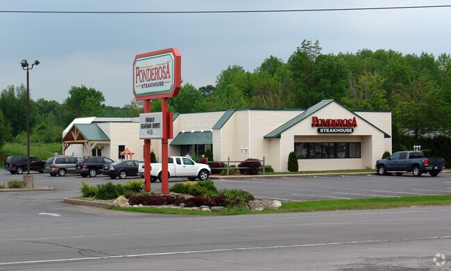
Property Record
3734 State Route 13, Pulaski, NY 13142

NEARBY LISTINGS FOR SALE OR LEASE
-
-
View all Pulaski listings for lease on LoopNet.com
Property Detail
3734 State Route 13
355001-071-005-0001-010-001-0000
LOT 158 491-006-000
Storesoffices
Oswego
X
New York
36075C0186G
10.010
2025
1.03 AC
2024
Oswego County
020301
Syracuse
4,845 SF
Syracuse, NY
DEMOGRAPHICS near 3734 State Route 13
1 Mile
3 Mile
5 Mile
2024 Total Population
555
3,492
6,496
2029 Population
551
3,481
6,529
Pop Growth 2024-2029
(0.72%)
(0.32%)
+ 0.51%
Average Age
44
42
42
2024 Total Households
255
1,486
2,628
HH Growth 2024-2029
(0.78%)
(0.40%)
+ 0.42%
Median Household Inc
$46,785
$54,112
$58,009
Avg Household Size
2.20
2.30
2.40
2024 Avg HH Vehicles
2.00
2.00
2.00
Median Home Value
$139,344
$142,984
$144,303
Median Year Built
1971
1970
1972
Nearby Places
Map Layers
Map Styles
 Street
 Aerial
- Restaurants
- Banks
- Shops
- Fitness
- Groceries
SALE & LEASE HISTORY
LISTING DATE
SALE/LEASE

Sep 24, 2016
For Sale
Sep 23, 2016
For Sale
May 23, 2017
For Sale
Jun 02, 2017
For Sale
Jul 16, 2020
For Lease
Apr 01, 2019
For Sale
Nearby Properties
Address
Land Use
TOTAL SIZE
Lot Size
Zoning
Address
Land Use
TOTAL SIZE
Lot Size
Zoning
5,600 SF
21.48 AC
Address
Land Use
TOTAL SIZE
Lot Size
Zoning
166,960 SF
152.14 AC
06 - INDUS
Address
Land Use
TOTAL SIZE
Lot Size
Zoning
27,944 SF
34.51 AC
01 - NOT Z
Address
Land Use
TOTAL SIZE
Lot Size
Zoning
71,806 SF
13.89 AC
02 - SINGL
Address
Land Use
TOTAL SIZE
Lot Size
Zoning
91,883 SF
16.10 AC
02 - SINGL
Address
Land Use
TOTAL SIZE
Lot Size
Zoning
86,840 SF
4.84 AC
02 - SINGL
Address
Land Use
TOTAL SIZE
Lot Size
Zoning
73,362 SF
22.66 AC
03 - MULTI
Address
Land Use
TOTAL SIZE
Lot Size
Zoning
54,602 SF
7.29 AC
Address
Land Use
TOTAL SIZE
Lot Size
Zoning
21,994 SF
8 AC
02 - SINGL
Address
Land Use
TOTAL SIZE
Lot Size
Zoning
2,368 SF
5.42 AC
02 - SINGL
Address
Land Use
TOTAL SIZE
Lot Size
Zoning
1,440 SF
28.01 AC
06 - INDUS
Address
Land Use
TOTAL SIZE
Lot Size
Zoning
Address
Land Use
TOTAL SIZE
Lot Size
Zoning
67.48 AC
Address
Land Use
TOTAL SIZE
Lot Size
Zoning
49.53 AC
02 - SINGL
Address
Land Use
TOTAL SIZE
Lot Size
Zoning
14,914 SF
1.88 AC
Address
Land Use
TOTAL SIZE
Lot Size
Zoning
23,483 SF
0.71 AC
05 - COMME
Address
Land Use
TOTAL SIZE
Lot Size
Zoning
17,330 SF
2.64 AC
Address
Land Use
TOTAL SIZE
Lot Size
Zoning
28,896 SF
45.86 AC
02 - SINGL
Address
Land Use
TOTAL SIZE
Lot Size
Zoning
11,282 SF
0.47 AC
05 - COMME
Address
Land Use
TOTAL SIZE
Lot Size
Zoning
13,262 SF
0.56 AC
05 - COMME
Address
Land Use
TOTAL SIZE
Lot Size
Zoning
18,868 SF
17.42 AC
02 - SINGL
Address
Land Use
TOTAL SIZE
Lot Size
Zoning
13,772 SF
2.59 AC
02 - SINGL
Address
Land Use
TOTAL SIZE
Lot Size
Zoning
4,488 SF
3.91 AC
01 - NOT Z
Address
Land Use
TOTAL SIZE
Lot Size
Zoning
14,700 SF
2.81 AC
01 - NOT Z
Address
Land Use
TOTAL SIZE
Lot Size
Zoning
11,550 SF
1.59 AC
05
Address
Land Use
TOTAL SIZE
Lot Size
Zoning
4.41 AC
02 - SINGL
Address
Land Use
TOTAL SIZE
Lot Size
Zoning
11,275 SF
7.21 AC
02 - SINGL
Address
Land Use
TOTAL SIZE
Lot Size
Zoning
14,396 SF
1.26 AC
05 - COMME
Address
Land Use
TOTAL SIZE
Lot Size
Zoning
28,700 SF
2.59 AC
05 - COMME
Address
Land Use
TOTAL SIZE
Lot Size
Zoning
10,080 SF
0.72 AC
01 - NOT Z
The World's #1 Commercial Real Estate Marketplace
Connect with us
© 2025 CoStar Group
The information above has been obtained from sources believed reliable. While we do not doubt its accuracy we have not verified it and make no guarantee, warranty or representation about it. It is your responsibility to independently confirm its accuracy and completeness. Any projections, opinions, assumptions, or estimates used are for example only and do not represent the current or future performance of the property. The value of this transaction to you depends on tax and other factors which should be evaluated by your tax, financial, and legal advisors. You and your advisors should conduct a careful, independent investigation of the property to determine to your satisfaction the suitability of the property for your needs.