Property Record
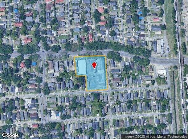
3736 Gentilly Blvd, New Orleans, LA 70122

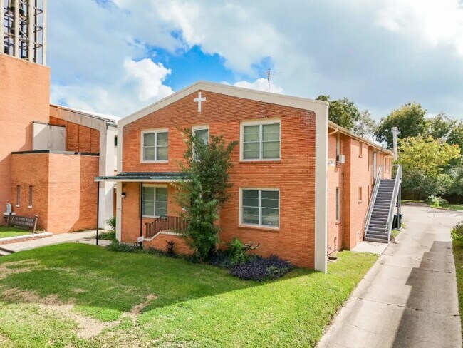
This Property Is For Sale
NEARBY LISTINGS FOR SALE OR LEASE
Property Detail
3736 Gentilly Blvd
New Orleans-Metairie, LA
Blvd Hts
3-8W-3-073-18
BLVD HGHTS SQ C LOTS 12 13 GENTILLY 50X197 LOTS 14 THRU 17 GENTILLY 100X98 LOTS 18 THRU 25 GENTILLY AND LOTUS 200X198 OVER 143 LOTS 26
Religious
Orleans
X
Louisiana
22051C0150F
12
0
2.15 AC
2025
Gentilly/St Claude
002402
New Orleans/Metairie/Kenner
DEMOGRAPHICS near 3736 Gentilly Blvd
1 Mile
3 Mile
5 Mile
2024 Total Population
15,016
100,646
239,788
2029 Population
14,286
96,834
232,352
Pop Growth 2024-2029
(4.86%)
(3.79%)
(3.10%)
Average Age
42
42
41
2024 Total Households
6,221
44,370
106,838
HH Growth 2024-2029
(5.38%)
(3.95%)
(3.01%)
Median Household Inc
$41,899
$39,437
$43,071
Avg Household Size
2.20
2.10
2.10
2024 Avg HH Vehicles
1.00
1.00
1.00
Median Home Value
$214,762
$257,765
$277,269
Median Year Built
1955
1953
1957
Nearby Places
Map Layers
Map Styles
 Street
 Aerial
- Restaurants
- Banks
- Shops
- Fitness
- Groceries
PUBLIC TRANSPORTATION
COMMUTER RAIL
New Orleans Union Passenger Terminal (City of New Orleans - Amtrak, Crescent - Amtrak, Sunset Limited - Amtrak)
DRIVE
WALK
Distance
New Orleans Union Passenger Terminal (City of New Orleans - Amtrak, Crescent - Amtrak, Sunset Limited - Amtrak)
11 min
5.5 mi
AIRPORT
Louis Armstrong New Orleans International
DRIVE
WALK
Distance
Louis Armstrong New Orleans International
22 min
15.2 mi
Freight Ports
Port of New Orleans
DRIVE
WALK
Distance
Port of New Orleans
17 min
7.9 mi
Nearby Properties
Address
Land Use
TOTAL SIZE
Lot Size
Zoning
Address
Land Use
TOTAL SIZE
Lot Size
Zoning
Address
Land Use
TOTAL SIZE
Lot Size
Zoning
Address
Land Use
TOTAL SIZE
Lot Size
Zoning
150.60 AC
EC
Address
Land Use
TOTAL SIZE
Lot Size
Zoning
22.17 AC
Address
Land Use
TOTAL SIZE
Lot Size
Zoning
33.64 AC
EC
Address
Land Use
TOTAL SIZE
Lot Size
Zoning
225,284 SF
16.83 AC
S-RD
Address
Land Use
TOTAL SIZE
Lot Size
Zoning
224,374 SF
92.67 AC
HU-RD1
Address
Land Use
TOTAL SIZE
Lot Size
Zoning
189,613 SF
71.45 AC
S-RD
Address
Land Use
TOTAL SIZE
Lot Size
Zoning
8,300 SF
30.83 AC
EC
Address
Land Use
TOTAL SIZE
Lot Size
Zoning
14.83 AC
EC
Address
Land Use
TOTAL SIZE
Lot Size
Zoning
484,670 SF
18.69 AC
EC
Address
Land Use
TOTAL SIZE
Lot Size
Zoning
173,008 SF
4.03 AC
S-RS
Address
Land Use
TOTAL SIZE
Lot Size
Zoning
Address
Land Use
TOTAL SIZE
Lot Size
Zoning
20.49 AC
S-RS
Address
Land Use
TOTAL SIZE
Lot Size
Zoning
183.59 AC
OS-R
Address
Land Use
TOTAL SIZE
Lot Size
Zoning
148,746 SF
2.19 AC
HMR-3
Address
Land Use
TOTAL SIZE
Lot Size
Zoning
Address
Land Use
TOTAL SIZE
Lot Size
Zoning
136,984 SF
4.67 AC
S-RS
Address
Land Use
TOTAL SIZE
Lot Size
Zoning
98,642 SF
7.30 AC
HU-RS
Address
Land Use
TOTAL SIZE
Lot Size
Zoning
1.14 AC
S-B2
Address
Land Use
TOTAL SIZE
Lot Size
Zoning
104,900 SF
7.37 AC
S-RS
Address
Land Use
TOTAL SIZE
Lot Size
Zoning
435,732 SF
29.06 AC
LI
Address
Land Use
TOTAL SIZE
Lot Size
Zoning
31,894 SF
500 AC
MI
Address
Land Use
TOTAL SIZE
Lot Size
Zoning
13,496 SF
3.01 AC
HU-RD2
Address
Land Use
TOTAL SIZE
Lot Size
Zoning
210,959 SF
6.61 AC
EC
Address
Land Use
TOTAL SIZE
Lot Size
Zoning
7.32 AC
S-RS
Address
Land Use
TOTAL SIZE
Lot Size
Zoning
93,152 SF
2.21 AC
HU-RD2
Address
Land Use
TOTAL SIZE
Lot Size
Zoning
13.23 AC
MI
Address
Land Use
TOTAL SIZE
Lot Size
Zoning
3.06 AC
HU-RD1
The World's #1 Commercial Real Estate Marketplace
Connect with us
© 2025 CoStar Group
The information above has been obtained from sources believed reliable. While we do not doubt its accuracy we have not verified it and make no guarantee, warranty or representation about it. It is your responsibility to independently confirm its accuracy and completeness. Any projections, opinions, assumptions, or estimates used are for example only and do not represent the current or future performance of the property. The value of this transaction to you depends on tax and other factors which should be evaluated by your tax, financial, and legal advisors. You and your advisors should conduct a careful, independent investigation of the property to determine to your satisfaction the suitability of the property for your needs.