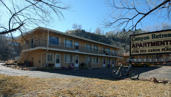
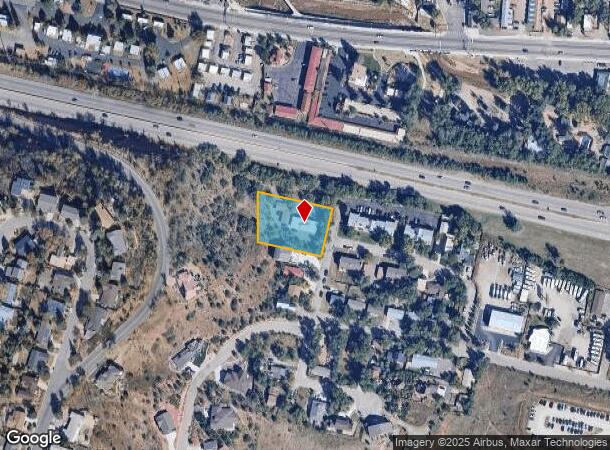
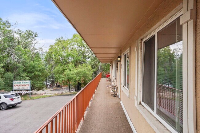
Property Record
3737 Red Canon Ave, Colorado Springs, CO 80904

NEARBY LISTINGS FOR SALE OR LEASE
Property Detail
3737 Red Canon Ave
Colorado Springs, CO
High Street Sub
74033-25-022
El Paso
Duplex
Colorado
X
0.75 AC
08041C0707G
Outer Northwest El Paso County
5,002 SF
Colorado Springs
DEMOGRAPHICS near 3737 Red Canon Ave
1 Mile
3 Mile
5 Mile
2024 Total Population
3,911
31,314
92,427
2029 Population
4,086
32,776
96,620
Pop Growth 2024-2029
+ 4.47%
+ 4.67%
+ 4.54%
Average Age
48
45
43
2024 Total Households
1,880
14,961
42,930
HH Growth 2024-2029
+ 4.68%
+ 4.99%
+ 4.81%
Median Household Inc
$83,770
$72,814
$67,628
Avg Household Size
2.00
2.00
2.00
2024 Avg HH Vehicles
2.00
2.00
2.00
Median Home Value
$540,580
$465,209
$451,721
Median Year Built
1970
1975
1969
Nearby Places
- Restaurants
- Banks
- Shops
- Fitness
- Groceries
PUBLIC TRANSPORTATION
AIRPORT
City of Colorado Springs Municipal
DRIVE
WALK
Distance
City of Colorado Springs Municipal
28 min
14.6 mi
SALE & LEASE HISTORY
LISTING DATE
SALE/LEASE

Sep 28, 2017
For Sale
Sep 28, 2017
For Sale
Aug 24, 2023
For Sale
Nearby Properties
Address
Land Use
TOTAL SIZE
Lot Size
Zoning
Address
Land Use
TOTAL SIZE
Lot Size
Zoning
107,247 SF
56.98 AC
R-E PF
Address
Land Use
TOTAL SIZE
Lot Size
Zoning
198,916 SF
31.69 AC
PF/CR SS
Address
Land Use
TOTAL SIZE
Lot Size
Zoning
139,621 SF
403.34 AC
A R-E HS
Address
Land Use
TOTAL SIZE
Lot Size
Zoning
2,422 SF
616.19 AC
PK MX-I PD
Address
Land Use
TOTAL SIZE
Lot Size
Zoning
99,488 SF
13.01 AC
PDZ
Address
Land Use
TOTAL SIZE
Lot Size
Zoning
75,349 SF
27.75 AC
EPC
Address
Land Use
TOTAL SIZE
Lot Size
Zoning
24,420 SF
2.79 AC
PK
Address
Land Use
TOTAL SIZE
Lot Size
Zoning
45,268 SF
8.37 AC
PDZ UV
Address
Land Use
TOTAL SIZE
Lot Size
Zoning
37,196 SF
3 AC
PDZ
Address
Land Use
TOTAL SIZE
Lot Size
Zoning
99,085 SF
6.85 AC
R-1 6
Address
Land Use
TOTAL SIZE
Lot Size
Zoning
331,438 SF
14.63 AC
PDZ
Address
Land Use
TOTAL SIZE
Lot Size
Zoning
282,722 SF
11.15 AC
PDZ HS SS
Address
Land Use
TOTAL SIZE
Lot Size
Zoning
34,126 SF
1.37 AC
Address
Land Use
TOTAL SIZE
Lot Size
Zoning
129,525 SF
9 AC
PDZ SS
Address
Land Use
TOTAL SIZE
Lot Size
Zoning
212,439 SF
12.67 AC
R-5 UV
Address
Land Use
TOTAL SIZE
Lot Size
Zoning
1,017 SF
77 AC
PK HS SS
Address
Land Use
TOTAL SIZE
Lot Size
Zoning
254,039 SF
13.47 AC
R-5 CU
Address
Land Use
TOTAL SIZE
Lot Size
Zoning
30,324 SF
9.42 AC
R-2
Address
Land Use
TOTAL SIZE
Lot Size
Zoning
6,493 SF
97.13 AC
PF PK SS
Address
Land Use
TOTAL SIZE
Lot Size
Zoning
267,790 SF
15.13 AC
PDZ HS
Address
Land Use
TOTAL SIZE
Lot Size
Zoning
115,608 SF
9.45 AC
MX-M
Address
Land Use
TOTAL SIZE
Lot Size
Zoning
1,050 SF
28.55 AC
PUD
Address
Land Use
TOTAL SIZE
Lot Size
Zoning
157,471 SF
0.02 AC
PUD,HS
Address
Land Use
TOTAL SIZE
Lot Size
Zoning
6,413 SF
118.25 AC
PK SS
Address
Land Use
TOTAL SIZE
Lot Size
Zoning
17,764 SF
1.63 AC
PDZ
Address
Land Use
TOTAL SIZE
Lot Size
Zoning
255,307 SF
18.58 AC
R-5
Address
Land Use
TOTAL SIZE
Lot Size
Zoning
20,147 SF
38.98 AC
PK HS
Address
Land Use
TOTAL SIZE
Lot Size
Zoning
127.25 AC
PK HS
Address
Land Use
TOTAL SIZE
Lot Size
Zoning
27,483 SF
7.83 AC
R-2 CU
Address
Land Use
TOTAL SIZE
Lot Size
Zoning
31,314 SF
1.55 AC
MX-M/CR
The World's #1 Commercial Real Estate Marketplace
Connect with us
© 2025 CoStar Group
The information above has been obtained from sources believed reliable. While we do not doubt its accuracy we have not verified it and make no guarantee, warranty or representation about it. It is your responsibility to independently confirm its accuracy and completeness. Any projections, opinions, assumptions, or estimates used are for example only and do not represent the current or future performance of the property. The value of this transaction to you depends on tax and other factors which should be evaluated by your tax, financial, and legal advisors. You and your advisors should conduct a careful, independent investigation of the property to determine to your satisfaction the suitability of the property for your needs.