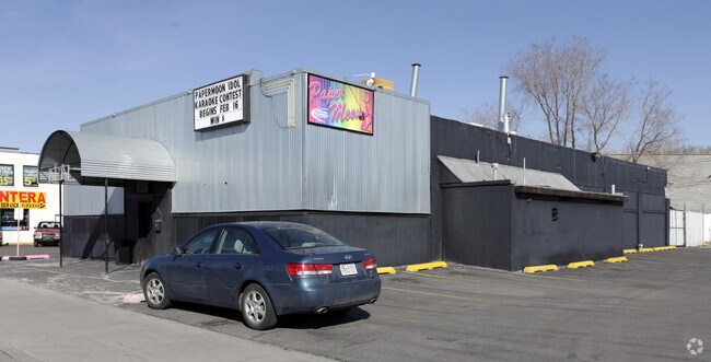
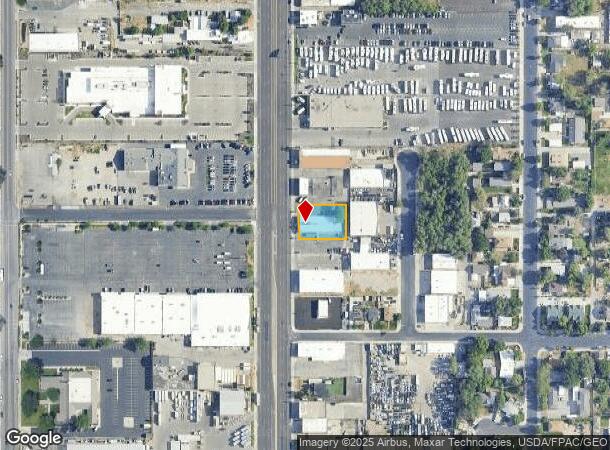
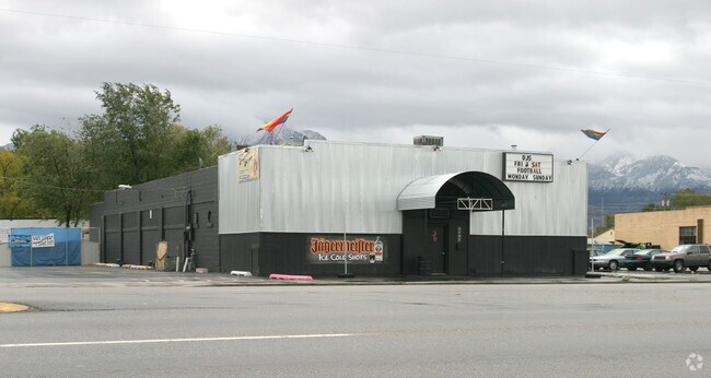
Property Record
3737 S State St, South Salt Lake, UT 84115
NEARBY LISTINGS FOR SALE OR LEASE
Property Detail
3737 S State St
Salt Lake City, UT
Longview Park Add
16-31-152-026-0000
LOTS 13 TO 16, BLK 6, LONGVIEW PARK ADD. TOGETHER WITH 1/2 OF VACATED ALLEY ABUTTING ON THE EAST. 0906-0496 7173-1100,1102 8845-2201 8844-0188 9061-7621 09871-4225
Storebuilding
Salt Lake
X
Utah
49035C0284G
13-16
2024
0.35 AC
2025
Central Valley East
111701
Salt Lake City
5,626 SF
DEMOGRAPHICS near 3737 S State St
1 Mile
3 Mile
5 Mile
2024 Total Population
23,035
150,473
382,385
2029 Population
23,580
152,276
386,567
Pop Growth 2024-2029
+ 2.37%
+ 1.20%
+ 1.09%
Average Age
35
37
38
2024 Total Households
9,656
62,280
148,821
HH Growth 2024-2029
+ 2.34%
+ 1.29%
+ 1.19%
Median Household Inc
$50,419
$62,319
$70,956
Avg Household Size
2.30
2.30
2.50
2024 Avg HH Vehicles
1.00
2.00
2.00
Median Home Value
$341,711
$407,379
$455,143
Median Year Built
1987
1977
1974
Nearby Places
Map Layers
Map Styles
 Street
 Aerial
- Restaurants
- Banks
- Shops
- Fitness
- Groceries
PUBLIC TRANSPORTATION
TRANSIT/SUBWAY
Meadowbrook (TRAX Murray/Midvale/University Line - Utah Transit Authority (UTA), TRAX Salt Lake/Sandy Line - Utah Transit Authority (UTA))
DRIVE
WALK
Distance
Meadowbrook (TRAX Murray/Midvale/University Line - Utah Transit Authority (UTA), TRAX Salt Lake/Sandy Line - Utah Transit Authority (UTA))
2 min
12 min
0.7 mi
COMMUTER RAIL
North Temple Station (FrontRunner - Utah Transit Authority (UTA))
DRIVE
WALK
Distance
North Temple Station (FrontRunner - Utah Transit Authority (UTA))
12 min
7.0 mi
Warm Springs Relief Point (FrontRunner - Utah Transit Authority (UTA))
DRIVE
WALK
Distance
Warm Springs Relief Point (FrontRunner - Utah Transit Authority (UTA))
13 min
8.4 mi
AIRPORT
Salt Lake City International
DRIVE
WALK
Distance
Salt Lake City International
16 min
11.0 mi
Freight Ports
Port of Stockton
DRIVE
WALK
Distance
Port of Stockton
716 min
701.4 mi
SALE & LEASE HISTORY
LISTING DATE
SALE/LEASE

Nov 03, 2016
For Lease
Nov 03, 2016
For Sale
May 18, 2018
For Sale
Nearby Properties
Address
Land Use
TOTAL SIZE
Lot Size
Zoning
Address
Land Use
TOTAL SIZE
Lot Size
Zoning
2,024,859 SF
63 AC
C D C
Address
Land Use
TOTAL SIZE
Lot Size
Zoning
488,509 SF
36.03 AC
FLEX
Address
Land Use
TOTAL SIZE
Lot Size
Zoning
35,897 SF
28.61 AC
RM-12
Address
Land Use
TOTAL SIZE
Lot Size
Zoning
163,932 SF
14.65 AC
PL
Address
Land Use
TOTAL SIZE
Lot Size
Zoning
828,269 SF
9.06 AC
RM
Address
Land Use
TOTAL SIZE
Lot Size
Zoning
691,463 SF
17.80 AC
RM
Address
Land Use
TOTAL SIZE
Lot Size
Zoning
524,108 SF
34.46 AC
RM
Address
Land Use
TOTAL SIZE
Lot Size
Zoning
128,997 SF
3.04 AC
ESN
Address
Land Use
TOTAL SIZE
Lot Size
Zoning
521,964 SF
3.23 AC
T-O-D
Address
Land Use
TOTAL SIZE
Lot Size
Zoning
297,476 SF
1.62 AC
CSHBD2
Address
Land Use
TOTAL SIZE
Lot Size
Zoning
185,436 SF
25.23 AC
RM
Address
Land Use
TOTAL SIZE
Lot Size
Zoning
302,944 SF
5.47 AC
Address
Land Use
TOTAL SIZE
Lot Size
Zoning
369,717 SF
2.50 AC
RO
Address
Land Use
TOTAL SIZE
Lot Size
Zoning
502,104 SF
4.11 AC
E ST C
Address
Land Use
TOTAL SIZE
Lot Size
Zoning
412,006 SF
1.70 AC
C3
Address
Land Use
TOTAL SIZE
Lot Size
Zoning
369,377 SF
1.65 AC
Address
Land Use
TOTAL SIZE
Lot Size
Zoning
179,702 SF
16.99 AC
1108
Address
Land Use
TOTAL SIZE
Lot Size
Zoning
426,600 SF
1.61 AC
CSHBD1
Address
Land Use
TOTAL SIZE
Lot Size
Zoning
95,854 SF
15.42 AC
CC
Address
Land Use
TOTAL SIZE
Lot Size
Zoning
21,057 SF
17.96 AC
RM20
Address
Land Use
TOTAL SIZE
Lot Size
Zoning
903,167 SF
1.90 AC
CSHBD1
Address
Land Use
TOTAL SIZE
Lot Size
Zoning
195,790 SF
14.32 AC
RM
Address
Land Use
TOTAL SIZE
Lot Size
Zoning
125,518 SF
11.03 AC
RMZC
Address
Land Use
TOTAL SIZE
Lot Size
Zoning
178,102 SF
15.95 AC
C-3
Address
Land Use
TOTAL SIZE
Lot Size
Zoning
33,164 SF
6.88 AC
RM
Address
Land Use
TOTAL SIZE
Lot Size
Zoning
37,563 SF
15.34 AC
RM20
Address
Land Use
TOTAL SIZE
Lot Size
Zoning
84,870 SF
9.76 AC
MPMU
Address
Land Use
TOTAL SIZE
Lot Size
Zoning
347,330 SF
6.91 AC
CC
Address
Land Use
TOTAL SIZE
Lot Size
Zoning
217,700 SF
52.59 AC
FLEX
Address
Land Use
TOTAL SIZE
Lot Size
Zoning
56,867 SF
5.33 AC
MIXED
The World's #1 Commercial Real Estate Marketplace
Connect with us
© 2025 CoStar Group
The information above has been obtained from sources believed reliable. While we do not doubt its accuracy we have not verified it and make no guarantee, warranty or representation about it. It is your responsibility to independently confirm its accuracy and completeness. Any projections, opinions, assumptions, or estimates used are for example only and do not represent the current or future performance of the property. The value of this transaction to you depends on tax and other factors which should be evaluated by your tax, financial, and legal advisors. You and your advisors should conduct a careful, independent investigation of the property to determine to your satisfaction the suitability of the property for your needs.