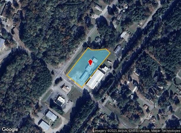
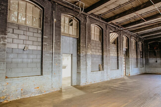
Property Record
3737 Us 1 Hwy N, Southern Pines, NC 28387
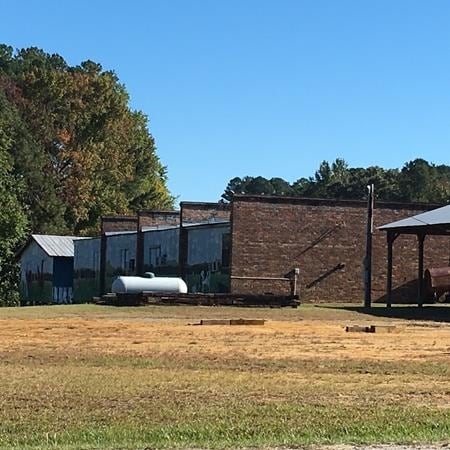
This Property Is For Sale
NEARBY LISTINGS FOR SALE OR LEASE
-
-
View all Southern Pines listings for sale on LoopNet.com
Property Detail
3737 Us 1 Hwy N
9514-00-36-9183
LOT 1
Warehouse
Moore
X
North Carolina
3710951400J
1
2024
2.39 AC
2024
North Carolina Southeast Area
950900
Other Market Areas
4,040 SF
Pinehurst-Southern Pines, NC
DEMOGRAPHICS near 3737 Us 1 Hwy N
1 Mile
3 Mile
5 Mile
2024 Total Population
756
3,216
11,527
2029 Population
861
3,653
13,182
Pop Growth 2024-2029
+ 13.89%
+ 13.59%
+ 14.36%
Average Age
41
40
40
2024 Total Households
308
1,298
4,531
HH Growth 2024-2029
+ 14.29%
+ 13.94%
+ 14.65%
Median Household Inc
$58,648
$59,575
$71,659
Avg Household Size
2.40
2.50
2.50
2024 Avg HH Vehicles
2.00
2.00
2.00
Median Home Value
$308,333
$277,940
$305,490
Median Year Built
1983
1984
1992
Nearby Places
Map Layers
Map Styles
 Street
 Aerial
- Restaurants
- Banks
- Shops
- Fitness
- Groceries
PUBLIC TRANSPORTATION
COMMUTER RAIL
DRIVE
WALK
Distance
14 min
8.4 mi
AIRPORT
Fayetteville Regional/Grannis Field
DRIVE
WALK
Distance
Fayetteville Regional/Grannis Field
56 min
38.0 mi
Nearby Properties
Address
Land Use
TOTAL SIZE
Lot Size
Zoning
Address
Land Use
TOTAL SIZE
Lot Size
Zoning
56,159 SF
49.01 AC
RA
Address
Land Use
TOTAL SIZE
Lot Size
Zoning
65,952 SF
18.93 AC
R20
Address
Land Use
TOTAL SIZE
Lot Size
Zoning
696.78 AC
Address
Land Use
TOTAL SIZE
Lot Size
Zoning
1,550 SF
118.28 AC
Address
Land Use
TOTAL SIZE
Lot Size
Zoning
990 SF
59.63 AC
RE
Address
Land Use
TOTAL SIZE
Lot Size
Zoning
458 AC
RA40
Address
Land Use
TOTAL SIZE
Lot Size
Zoning
7,364 SF
4.30 AC
B2
Address
Land Use
TOTAL SIZE
Lot Size
Zoning
19,576 SF
3.59 AC
TBD
Address
Land Use
TOTAL SIZE
Lot Size
Zoning
2,278 SF
0.69 AC
RM20
Address
Land Use
TOTAL SIZE
Lot Size
Zoning
1,728 SF
24.54 AC
RE
Address
Land Use
TOTAL SIZE
Lot Size
Zoning
1,292 SF
39.60 AC
RE
Address
Land Use
TOTAL SIZE
Lot Size
Zoning
3,600 SF
4.09 AC
TBD
Address
Land Use
TOTAL SIZE
Lot Size
Zoning
5,760 SF
10.62 AC
Address
Land Use
TOTAL SIZE
Lot Size
Zoning
12.98 AC
RA40
Address
Land Use
TOTAL SIZE
Lot Size
Zoning
4,400 SF
2.43 AC
Address
Land Use
TOTAL SIZE
Lot Size
Zoning
3,327 SF
45.98 AC
Address
Land Use
TOTAL SIZE
Lot Size
Zoning
696.78 AC
Address
Land Use
TOTAL SIZE
Lot Size
Zoning
1,732 SF
15.04 AC
RA
Address
Land Use
TOTAL SIZE
Lot Size
Zoning
6,397 SF
11.73 AC
RA40
Address
Land Use
TOTAL SIZE
Lot Size
Zoning
6,500 SF
10.91 AC
RE
Address
Land Use
TOTAL SIZE
Lot Size
Zoning
253.46 AC
RA
Address
Land Use
TOTAL SIZE
Lot Size
Zoning
3,114 SF
6.39 AC
MULTI
Address
Land Use
TOTAL SIZE
Lot Size
Zoning
2,490 SF
10.10 AC
RE
Address
Land Use
TOTAL SIZE
Lot Size
Zoning
2,038 SF
175 AC
MULTI
Address
Land Use
TOTAL SIZE
Lot Size
Zoning
1,456 SF
17.90 AC
MULTI
Address
Land Use
TOTAL SIZE
Lot Size
Zoning
2,280 SF
41.22 AC
RA
Address
Land Use
TOTAL SIZE
Lot Size
Zoning
42.50 AC
RE
Address
Land Use
TOTAL SIZE
Lot Size
Zoning
4,040 SF
10.05 AC
RE
Address
Land Use
TOTAL SIZE
Lot Size
Zoning
1,785 SF
118.28 AC
Address
Land Use
TOTAL SIZE
Lot Size
Zoning
448 SF
314.88 AC
RE
The World's #1 Commercial Real Estate Marketplace
Connect with us
© 2025 CoStar Group
The information above has been obtained from sources believed reliable. While we do not doubt its accuracy we have not verified it and make no guarantee, warranty or representation about it. It is your responsibility to independently confirm its accuracy and completeness. Any projections, opinions, assumptions, or estimates used are for example only and do not represent the current or future performance of the property. The value of this transaction to you depends on tax and other factors which should be evaluated by your tax, financial, and legal advisors. You and your advisors should conduct a careful, independent investigation of the property to determine to your satisfaction the suitability of the property for your needs.