Property Record
374 Troutman St, Brooklyn, NY 11237
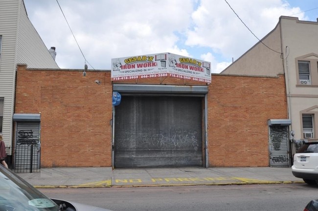

Property Detail
374 Troutman St
03188-0024
DOCID-2020110200687002
Warehouse
Kings
M1-1
New York
B and X Area of moderate flood hazard, usually the area between the limits of the 100-year and 500-year floods.
24
2025
0.29 AC
2026
North Brooklyn
044700
Long Island (New York)
12,500 SF
New York-Jersey City-White Plains, NY-NJ
NEARBY LISTINGS FOR SALE OR LEASE
DEMOGRAPHICS near 374 Troutman St
1 mile
3 mile
5 mile
2025 Total Population
131,654
1,058,280
3,350,131
2030 Population
130,309
1,053,523
3,371,105
Pop Growth 2025-2030
(1.02%)
(0.45%)
+ 0.63%
Average Age
36
38
40
2025 Total Households
48,028
397,975
1,358,193
HH Growth 2025-2030
(1.46%)
(0.74%)
+ 1.00%
Median Household Inc
$80,477
$81,460
$94,081
Avg Household Size
2.60
2.50
2.30
2025 Avg HH Vehicles
.00
.00
.00
Median Home Value
$943,489
$900,271
$867,202
Median Year Built
1948
1948
1950
Nearby Places
Map Layers
Map Styles
 Street
 Aerial
Layers
 Traffic
 Biking
Places
Listings with unknown addresses are not visible on the map
- Restaurants
- Banks
- Shops
- Fitness
- Groceries
PUBLIC TRANSPORTATION
TRANSIT/SUBWAY
Jefferson Street (L - New York MTA Subway (The Subway))
Drive
Walk
Distance
Jefferson Street (L - New York MTA Subway (The Subway))
1 min
1 min
0.1 mi
DeKalb Avenue (L Line) (L - New York MTA Subway (The Subway))
Drive
Walk
Distance
DeKalb Avenue (L Line) (L - New York MTA Subway (The Subway))
2 min
7 min
0.4 mi
Morgan Avenue (L - New York MTA Subway (The Subway))
Drive
Walk
Distance
Morgan Avenue (L - New York MTA Subway (The Subway))
3 min
11 min
0.6 mi
Knickerbocker Avenue (M Line) (M - New York MTA Subway (The Subway))
Drive
Walk
Distance
Knickerbocker Avenue (M Line) (M - New York MTA Subway (The Subway))
3 min
13 min
0.7 mi
Central Avenue (M - New York MTA Subway (The Subway))
Drive
Walk
Distance
Central Avenue (M - New York MTA Subway (The Subway))
3 min
14 min
0.7 mi
COMMUTER RAIL
Nostrand Avenue Station (Far Rockaway Branch - Long Island Rail Road, Hempstead Branch - Long Island Rail Road, Long Beach Branch - Long Island Rail Road, West Hempstead Branch - Long Island Rail Road)
Drive
Walk
Distance
Nostrand Avenue Station (Far Rockaway Branch - Long Island Rail Road, Hempstead Branch - Long Island Rail Road, Long Beach Branch - Long Island Rail Road, West Hempstead Branch - Long Island Rail Road)
10 min
3.1 mi
East New York Station (Far Rockaway Branch - Long Island Rail Road, Long Beach Branch - Long Island Rail Road, West Hempstead Branch - Long Island Rail Road)
Drive
Walk
Distance
East New York Station (Far Rockaway Branch - Long Island Rail Road, Long Beach Branch - Long Island Rail Road, West Hempstead Branch - Long Island Rail Road)
9 min
3.2 mi
AIRPORT
LaGuardia
Drive
Walk
Distance
LaGuardia
16 min
6.8 mi
John F Kennedy International
Drive
Walk
Distance
John F Kennedy International
21 min
11.6 mi
Newark Liberty International
Drive
Walk
Distance
Newark Liberty International
32 min
16.8 mi
Freight Ports
NY - Red Hook Container Terminal
Drive
Walk
Distance
NY - Red Hook Container Terminal
14 min
5.6 mi
SALE & LEASE HISTORY
LISTING DATE
SALE/LEASE

Sep 25, 2016
For Lease
May 22, 2020
For Lease
Nearby Properties
Address
Land Use
TOTAL SIZE
Lot Size
Zoning
Address
Land Use
TOTAL SIZE
Lot Size
Zoning
2,812,739 SF
2.10 AC
C5-3
Address
Land Use
TOTAL SIZE
Lot Size
Zoning
7,058,736 SF
147.61 AC
M3-1
Address
Land Use
TOTAL SIZE
Lot Size
Zoning
835,231 SF
11.32 AC
R6
Address
Land Use
TOTAL SIZE
Lot Size
Zoning
512,755 SF
1.19 AC
R6
Address
Land Use
TOTAL SIZE
Lot Size
Zoning
778,063 SF
2.15 AC
R8
Address
Land Use
TOTAL SIZE
Lot Size
Zoning
296,915 SF
0.31 AC
C5-3
Address
Land Use
TOTAL SIZE
Lot Size
Zoning
710,860 SF
1.52 AC
M15R9
Address
Land Use
TOTAL SIZE
Lot Size
Zoning
503,608 SF
1.64 AC
R8
Address
Land Use
TOTAL SIZE
Lot Size
Zoning
493,889 SF
1.84 AC
R7-3
Address
Land Use
TOTAL SIZE
Lot Size
Zoning
777,258 SF
4.67 AC
M3-2
Address
Land Use
TOTAL SIZE
Lot Size
Zoning
582,700 SF
1.20 AC
R8
Address
Land Use
TOTAL SIZE
Lot Size
Zoning
863,800 SF
2.71 AC
M1-4
Address
Land Use
TOTAL SIZE
Lot Size
Zoning
577,697 SF
4.49 AC
R7-3
Address
Land Use
TOTAL SIZE
Lot Size
Zoning
1,119,826 SF
2.76 AC
M1-4
Address
Land Use
TOTAL SIZE
Lot Size
Zoning
1,572,198 SF
22.06 AC
M1-2
Address
Land Use
TOTAL SIZE
Lot Size
Zoning
710,746 SF
1.88 AC
C63A
Address
Land Use
TOTAL SIZE
Lot Size
Zoning
404,186 SF
1.12 AC
R8
Address
Land Use
TOTAL SIZE
Lot Size
Zoning
1,150,500 SF
15.17 AC
R6
Address
Land Use
TOTAL SIZE
Lot Size
Zoning
555,920 SF
2.61 AC
M1-2
Address
Land Use
TOTAL SIZE
Lot Size
Zoning
8,750 SF
51.25 AC
PARK
Address
Land Use
TOTAL SIZE
Lot Size
Zoning
749,294 SF
5.03 AC
R8
Address
Land Use
TOTAL SIZE
Lot Size
Zoning
446,763 SF
12.52 AC
R6
Address
Land Use
TOTAL SIZE
Lot Size
Zoning
438,857 SF
0.48 AC
R8
Address
Land Use
TOTAL SIZE
Lot Size
Zoning
826,915 SF
8.83 AC
M3-1
Address
Land Use
TOTAL SIZE
Lot Size
Zoning
264,691 SF
5.17 AC
M1-2
Address
Land Use
TOTAL SIZE
Lot Size
Zoning
462,052 SF
1.08 AC
C63A
Address
Land Use
TOTAL SIZE
Lot Size
Zoning
363,205 SF
1.38 AC
M12R7A
Address
Land Use
TOTAL SIZE
Lot Size
Zoning
333,424 SF
1.78 AC
C45D
Address
Land Use
TOTAL SIZE
Lot Size
Zoning
147,396 SF
1.15 AC
M1-2
Address
Land Use
TOTAL SIZE
Lot Size
Zoning
395,696 SF
1.56 AC
C6-2
The World's #1 Commercial Real Estate Marketplace
Connect with us
© 2026 CoStar Group
The information above has been obtained from sources believed reliable. While we do not doubt its accuracy we have not verified it and make no guarantee, warranty or representation about it. It is your responsibility to independently confirm its accuracy and completeness. Any projections, opinions, assumptions, or estimates used are for example only and do not represent the current or future performance of the property. The value of this transaction to you depends on tax and other factors which should be evaluated by your tax, financial, and legal advisors. You and your advisors should conduct a careful, independent investigation of the property to determine to your satisfaction the suitability of the property for your needs.