Property Record
3745 Sw Wanamaker Rd, Topeka, KS 66610
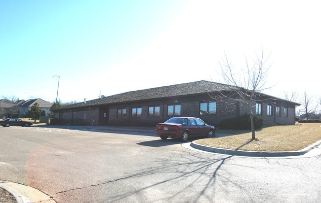

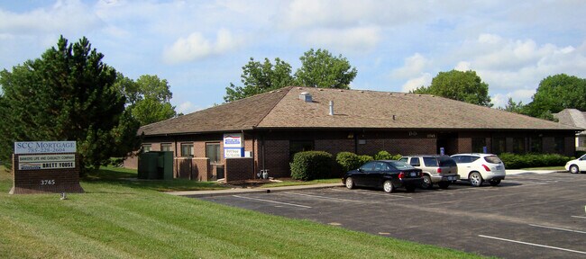
Property Detail
3745 Sw Wanamaker Rd
144-20-0-10-01-013-000
SHADYWOOD SOUTH SUB , BLOCK A , LOT 6 , BLOCK A LOT 6 SHADYWOOD SOUTH SUB SECTION 20 TOWNSHIP 12 RANGE 15
Officebuilding
Shawnee
OI1
Kansas
B and X Area of moderate flood hazard, usually the area between the limits of the 100-year and 500-year floods.
6
2024
0.96 AC
2025
Topeka
003605
Kansas City
7,400 SF
Topeka, KS
NEARBY LISTINGS FOR SALE OR LEASE
DEMOGRAPHICS near 3745 Sw Wanamaker Rd
1 mile
3 mile
5 mile
2025 Total Population
5,044
42,565
87,844
2030 Population
4,959
41,988
87,405
Pop Growth 2025-2030
(1.69%)
(1.36%)
(0.50%)
Average Age
46
43
42
2025 Total Households
2,132
18,343
38,092
HH Growth 2025-2030
(1.83%)
(1.45%)
(0.56%)
Median Household Inc
$95,076
$75,809
$67,690
Avg Household Size
2.30
2.20
2.20
2025 Avg HH Vehicles
2.00
2.00
2.00
Median Home Value
$286,524
$215,743
$186,224
Median Year Built
1989
1979
1973
Nearby Places
Map Layers
Map Styles
 Street
 Aerial
Layers
 Traffic
 Biking
Places
Listings with unknown addresses are not visible on the map
- Restaurants
- Banks
- Shops
- Fitness
- Groceries
PUBLIC TRANSPORTATION
COMMUTER RAIL
Drive
Walk
Distance
17 min
10.0 mi
SALE & LEASE HISTORY
LISTING DATE
SALE/LEASE

Mar 27, 2023
For Lease
Nearby Properties
Address
Land Use
TOTAL SIZE
Lot Size
Zoning
Address
Land Use
TOTAL SIZE
Lot Size
Zoning
189,886 SF
37.38 AC
RR1
Address
Land Use
TOTAL SIZE
Lot Size
Zoning
43,282 SF
19.33 AC
PUD,M2
Address
Land Use
TOTAL SIZE
Lot Size
Zoning
208,685 SF
38.23 AC
R1
Address
Land Use
TOTAL SIZE
Lot Size
Zoning
88,935 SF
20.24 AC
C4
Address
Land Use
TOTAL SIZE
Lot Size
Zoning
176,935 SF
37.83 AC
RR1
Address
Land Use
TOTAL SIZE
Lot Size
Zoning
6.95 AC
PUD,OI1
Address
Land Use
TOTAL SIZE
Lot Size
Zoning
81,364 SF
19.52 AC
R1
Address
Land Use
TOTAL SIZE
Lot Size
Zoning
11.05 AC
PUD,C2,C4,
Address
Land Use
TOTAL SIZE
Lot Size
Zoning
71,575 SF
10.93 AC
C2,C4
Address
Land Use
TOTAL SIZE
Lot Size
Zoning
19.37 AC
Address
Land Use
TOTAL SIZE
Lot Size
Zoning
59,337 SF
6.84 AC
R1
Address
Land Use
TOTAL SIZE
Lot Size
Zoning
72,482 SF
19.53 AC
R1
Address
Land Use
TOTAL SIZE
Lot Size
Zoning
51,636 SF
3.89 AC
C4
Address
Land Use
TOTAL SIZE
Lot Size
Zoning
57,380 SF
15.03 AC
RR1
Address
Land Use
TOTAL SIZE
Lot Size
Zoning
74,659 SF
15.24 AC
RR1
Address
Land Use
TOTAL SIZE
Lot Size
Zoning
50,795 SF
7.70 AC
R1
Address
Land Use
TOTAL SIZE
Lot Size
Zoning
36,511 SF
7.05 AC
R1
Address
Land Use
TOTAL SIZE
Lot Size
Zoning
61,383 SF
8.09 AC
R1
Address
Land Use
TOTAL SIZE
Lot Size
Zoning
37,132 SF
13.48 AC
R1
Address
Land Use
TOTAL SIZE
Lot Size
Zoning
84,794 SF
11.55 AC
C4
Address
Land Use
TOTAL SIZE
Lot Size
Zoning
115,103 SF
9.35 AC
C4
Address
Land Use
TOTAL SIZE
Lot Size
Zoning
40,280 SF
6.53 AC
R1
Address
Land Use
TOTAL SIZE
Lot Size
Zoning
26.73 AC
PUD,R1
Address
Land Use
TOTAL SIZE
Lot Size
Zoning
3.43 AC
PUD,C4,M3
Address
Land Use
TOTAL SIZE
Lot Size
Zoning
30,902 SF
2.83 AC
PUD,C4
Address
Land Use
TOTAL SIZE
Lot Size
Zoning
51,933 SF
16.73 AC
PUD,M2
Address
Land Use
TOTAL SIZE
Lot Size
Zoning
42,415 SF
7.56 AC
R1
Address
Land Use
TOTAL SIZE
Lot Size
Zoning
31,098 SF
5.88 AC
RR1
Address
Land Use
TOTAL SIZE
Lot Size
Zoning
173,406 SF
46.61 AC
Address
Land Use
TOTAL SIZE
Lot Size
Zoning
11,460 SF
5.03 AC
R1
The World's #1 Commercial Real Estate Marketplace
Connect with us
© 2026 CoStar Group
The information above has been obtained from sources believed reliable. While we do not doubt its accuracy we have not verified it and make no guarantee, warranty or representation about it. It is your responsibility to independently confirm its accuracy and completeness. Any projections, opinions, assumptions, or estimates used are for example only and do not represent the current or future performance of the property. The value of this transaction to you depends on tax and other factors which should be evaluated by your tax, financial, and legal advisors. You and your advisors should conduct a careful, independent investigation of the property to determine to your satisfaction the suitability of the property for your needs.