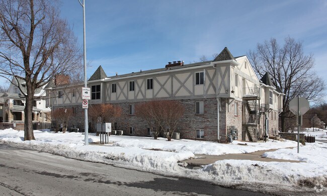
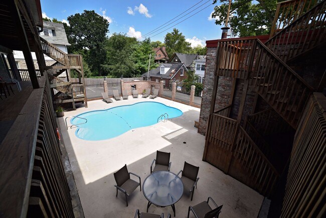
Property Record
3745 Warwick Blvd, Kansas City, MO 64111

NEARBY LISTINGS FOR SALE OR LEASE
Property Detail
3745 Warwick Blvd
Kansas City, MO-KS
The Londonaire Condominium
30-220-16-11-01-0-01-099
Jackson
Condominium
Missouri
X
0.44 AC
29095C0262G
Hanover Place
10,981 SF
Kansas City
DEMOGRAPHICS near 3745 Warwick Blvd
1 Mile
3 Mile
5 Mile
2024 Total Population
22,395
123,292
285,023
2029 Population
22,879
125,528
289,173
Pop Growth 2024-2029
+ 2.16%
+ 1.81%
+ 1.46%
Average Age
37
38
37
2024 Total Households
12,644
60,036
125,852
HH Growth 2024-2029
+ 2.20%
+ 1.77%
+ 1.57%
Median Household Inc
$54,953
$59,509
$55,877
Avg Household Size
1.70
1.90
2.10
2024 Avg HH Vehicles
1.00
1.00
1.00
Median Home Value
$302,029
$245,558
$213,488
Median Year Built
1949
1951
1952
Nearby Places
Map Layers
Map Styles
 Street
 Aerial
- Restaurants
- Banks
- Shops
- Fitness
- Groceries
PUBLIC TRANSPORTATION
COMMUTER RAIL
Kansas City (Lincoln Service Missouri River Runner - Amtrak, Missouri River Runner - Amtrak, Southwest Chief - Amtrak)
DRIVE
WALK
Distance
Kansas City (Lincoln Service Missouri River Runner - Amtrak, Missouri River Runner - Amtrak, Southwest Chief - Amtrak)
6 min
2.5 mi
AIRPORT
Kansas City International
DRIVE
WALK
Distance
Kansas City International
33 min
22.5 mi
Freight Ports
Tulsa Port Of Catoosa
DRIVE
WALK
Distance
Tulsa Port Of Catoosa
269 min
237.9 mi
Nearby Properties
Address
Land Use
TOTAL SIZE
Lot Size
Zoning
Address
Land Use
TOTAL SIZE
Lot Size
Zoning
761,113 SF
18.37 AC
KC3
Address
Land Use
TOTAL SIZE
Lot Size
Zoning
91,485 SF
10.11 AC
Address
Land Use
TOTAL SIZE
Lot Size
Zoning
208,800 SF
5.57 AC
KRP5
Address
Land Use
TOTAL SIZE
Lot Size
Zoning
172,810 SF
Address
Land Use
TOTAL SIZE
Lot Size
Zoning
191,956 SF
10.45 AC
KR1B
Address
Land Use
TOTAL SIZE
Lot Size
Zoning
568,235 SF
9.59 AC
Address
Land Use
TOTAL SIZE
Lot Size
Zoning
488,351 SF
8.34 AC
Address
Land Use
TOTAL SIZE
Lot Size
Zoning
1,825,083 SF
25.77 AC
Address
Land Use
TOTAL SIZE
Lot Size
Zoning
404,524 SF
5.51 AC
Address
Land Use
TOTAL SIZE
Lot Size
Zoning
711,196 SF
15.58 AC
Address
Land Use
TOTAL SIZE
Lot Size
Zoning
105,247 SF
0.72 AC
Address
Land Use
TOTAL SIZE
Lot Size
Zoning
277,042 SF
0.40 AC
Address
Land Use
TOTAL SIZE
Lot Size
Zoning
543,241 SF
8.39 AC
Address
Land Use
TOTAL SIZE
Lot Size
Zoning
257,647 SF
3.63 AC
Address
Land Use
TOTAL SIZE
Lot Size
Zoning
626,244 SF
16.41 AC
Address
Land Use
TOTAL SIZE
Lot Size
Zoning
44,491 SF
1.96 AC
C3A2
Address
Land Use
TOTAL SIZE
Lot Size
Zoning
81,578 SF
1.63 AC
Address
Land Use
TOTAL SIZE
Lot Size
Zoning
124,492 SF
4.24 AC
Address
Land Use
TOTAL SIZE
Lot Size
Zoning
115,627 SF
1.56 AC
Address
Land Use
TOTAL SIZE
Lot Size
Zoning
212,475 SF
30.20 AC
PUB
Address
Land Use
TOTAL SIZE
Lot Size
Zoning
157,488 SF
1.60 AC
Address
Land Use
TOTAL SIZE
Lot Size
Zoning
803,812 SF
5.85 AC
Address
Land Use
TOTAL SIZE
Lot Size
Zoning
69,130 SF
6.49 AC
R-1
Address
Land Use
TOTAL SIZE
Lot Size
Zoning
129,265 SF
1.17 AC
Address
Land Use
TOTAL SIZE
Lot Size
Zoning
274,622 SF
1.35 AC
Address
Land Use
TOTAL SIZE
Lot Size
Zoning
109,563 SF
0.98 AC
Address
Land Use
TOTAL SIZE
Lot Size
Zoning
149,157 SF
0.02 AC
URD
Address
Land Use
TOTAL SIZE
Lot Size
Zoning
342,989 SF
1.84 AC
Address
Land Use
TOTAL SIZE
Lot Size
Zoning
251,409 SF
3.39 AC
Address
Land Use
TOTAL SIZE
Lot Size
Zoning
238,003 SF
1.74 AC
The World's #1 Commercial Real Estate Marketplace
Connect with us
© 2026 CoStar Group
The information above has been obtained from sources believed reliable. While we do not doubt its accuracy we have not verified it and make no guarantee, warranty or representation about it. It is your responsibility to independently confirm its accuracy and completeness. Any projections, opinions, assumptions, or estimates used are for example only and do not represent the current or future performance of the property. The value of this transaction to you depends on tax and other factors which should be evaluated by your tax, financial, and legal advisors. You and your advisors should conduct a careful, independent investigation of the property to determine to your satisfaction the suitability of the property for your needs.