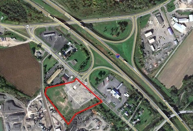
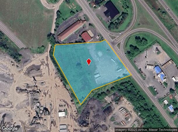
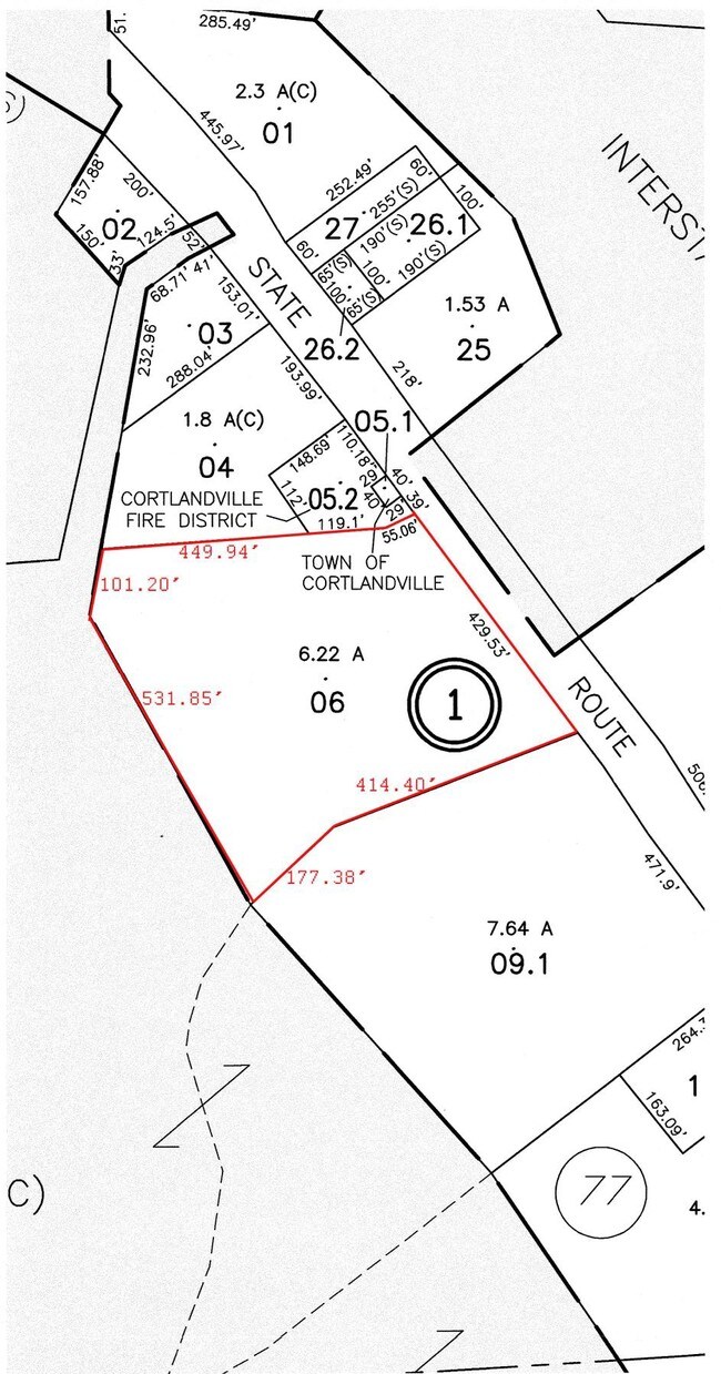
Property Record
3747 Route 11, Cortland, NY 13045
NEARBY LISTINGS FOR SALE OR LEASE
-
-
View all Cortland listings for sale on LoopNet.com
Property Detail
3747 Route 11
112289-097-002-0001-006-000-0000
Cortland
Commercialacreage
New York
X
6.000
36023C0234D
6.30 AC
2025
Cortland County
2024
Syracuse
970900
Cortland, NY
DEMOGRAPHICS near 3747 Route 11
1 Mile
3 Mile
5 Mile
2024 Total Population
217
15,244
29,375
2029 Population
209
15,008
28,930
Pop Growth 2024-2029
(3.69%)
(1.55%)
(1.51%)
Average Age
43
38
39
2024 Total Households
88
5,946
11,399
HH Growth 2024-2029
(4.55%)
(1.60%)
(1.61%)
Median Household Inc
$69,374
$47,945
$57,746
Avg Household Size
2.40
2.10
2.20
2024 Avg HH Vehicles
2.00
2.00
2.00
Median Home Value
$159,090
$130,269
$143,521
Median Year Built
1958
1949
1952
Nearby Places
Map Layers
Map Styles
 Street
 Aerial
- Restaurants
- Banks
- Shops
- Fitness
- Groceries
PUBLIC TRANSPORTATION
AIRPORT
Ithaca Tompkins International
DRIVE
WALK
Distance
Ithaca Tompkins International
37 min
22.0 mi
Freight Ports
Albany, NY Port
DRIVE
WALK
Distance
Albany, NY Port
193 min
152.9 mi
SALE & LEASE HISTORY
LISTING DATE
SALE/LEASE

Sep 24, 2016
For Sale
Nearby Properties
Address
Land Use
TOTAL SIZE
Lot Size
Zoning
Address
Land Use
TOTAL SIZE
Lot Size
Zoning
28,816 SF
5.90 AC
05 - COMME
Address
Land Use
TOTAL SIZE
Lot Size
Zoning
162,556 SF
22.70 AC
05 - COMME
Address
Land Use
TOTAL SIZE
Lot Size
Zoning
138,432 SF
1.01 AC
08 - GOVER
Address
Land Use
TOTAL SIZE
Lot Size
Zoning
111,968 SF
2.80 AC
08 - GOVER
Address
Land Use
TOTAL SIZE
Lot Size
Zoning
107,712 SF
4.77 AC
05 - COMME
Address
Land Use
TOTAL SIZE
Lot Size
Zoning
92,007 SF
9.74 AC
05 - COMME
Address
Land Use
TOTAL SIZE
Lot Size
Zoning
85,324 SF
4 AC
08 - GOVER
Address
Land Use
TOTAL SIZE
Lot Size
Zoning
157,298 SF
22.09 AC
05 - COMME
Address
Land Use
TOTAL SIZE
Lot Size
Zoning
42,508 SF
3.60 AC
08 - GOVER
Address
Land Use
TOTAL SIZE
Lot Size
Zoning
107,712 SF
4.77 AC
05 - COMME
Address
Land Use
TOTAL SIZE
Lot Size
Zoning
72,536 SF
2 AC
08 - GOVER
Address
Land Use
TOTAL SIZE
Lot Size
Zoning
96,605 SF
3.08 AC
05 - COMME
Address
Land Use
TOTAL SIZE
Lot Size
Zoning
438,796 SF
15.63 AC
05 - COMME
Address
Land Use
TOTAL SIZE
Lot Size
Zoning
12,402 SF
5 AC
03 - MULTI
Address
Land Use
TOTAL SIZE
Lot Size
Zoning
74,712 SF
1.50 AC
05 - COMME
Address
Land Use
TOTAL SIZE
Lot Size
Zoning
71,348 SF
5.90 AC
08 - GOVER
Address
Land Use
TOTAL SIZE
Lot Size
Zoning
18,960 SF
0.52 AC
08 - GOVER
Address
Land Use
TOTAL SIZE
Lot Size
Zoning
86,540 SF
1.40 AC
05 - COMME
Address
Land Use
TOTAL SIZE
Lot Size
Zoning
Address
Land Use
TOTAL SIZE
Lot Size
Zoning
41,480 SF
3 AC
08 - GOVER
Address
Land Use
TOTAL SIZE
Lot Size
Zoning
39.20 AC
04 - FARM
Address
Land Use
TOTAL SIZE
Lot Size
Zoning
45,056 SF
1.70 AC
08 - GOVER
Address
Land Use
TOTAL SIZE
Lot Size
Zoning
52,160 SF
2.20 AC
05 - COMME
Address
Land Use
TOTAL SIZE
Lot Size
Zoning
Address
Land Use
TOTAL SIZE
Lot Size
Zoning
91,836 SF
15.50 AC
05 - COMME
Address
Land Use
TOTAL SIZE
Lot Size
Zoning
176,040 SF
17 AC
05 - COMME
Address
Land Use
TOTAL SIZE
Lot Size
Zoning
47,228 SF
1.55 AC
05 - COMME
Address
Land Use
TOTAL SIZE
Lot Size
Zoning
31.20 AC
Address
Land Use
TOTAL SIZE
Lot Size
Zoning
48,499 SF
3 AC
05 - COMME
Address
Land Use
TOTAL SIZE
Lot Size
Zoning
4,140 SF
06 - INDUS
The World's #1 Commercial Real Estate Marketplace
Connect with us
© 2026 CoStar Group
The information above has been obtained from sources believed reliable. While we do not doubt its accuracy we have not verified it and make no guarantee, warranty or representation about it. It is your responsibility to independently confirm its accuracy and completeness. Any projections, opinions, assumptions, or estimates used are for example only and do not represent the current or future performance of the property. The value of this transaction to you depends on tax and other factors which should be evaluated by your tax, financial, and legal advisors. You and your advisors should conduct a careful, independent investigation of the property to determine to your satisfaction the suitability of the property for your needs.