Property Record
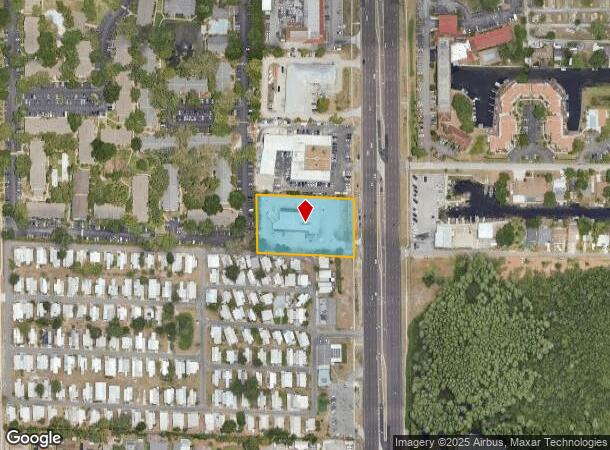
37490 Us Highway 19 N, Palm Harbor, FL 34684


NEARBY LISTINGS FOR SALE OR LEASE
Property Detail
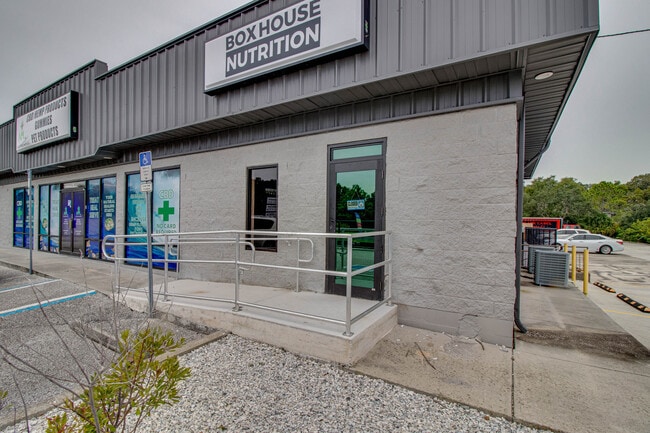
37490 Us Highway 19 N
Tampa-St. Petersburg-Clearwater, FL
Flowers Distribution
30-27-16-28696-000-0010
FLOWERS DISTRIBUTION CENTER LOT 1
Nightclub
Pinellas
X
Florida
12103C0076H
1
2024
1.55 AC
2025
North Pinellas
027212
Tampa/St Petersburg
8,559 SF
DEMOGRAPHICS near 37490 Us Highway 19 N
1 Mile
3 Mile
5 Mile
2024 Total Population
7,239
59,760
138,077
2029 Population
7,239
59,553
140,378
Pop Growth 2024-2029
0.00%
(0.35%)
+ 1.67%
Average Age
48
49
47
2024 Total Households
3,634
26,773
60,859
HH Growth 2024-2029
(0.30%)
(0.40%)
+ 1.58%
Median Household Inc
$56,961
$67,437
$65,903
Avg Household Size
2.00
2.20
2.20
2024 Avg HH Vehicles
2.00
2.00
2.00
Median Home Value
$313,415
$331,672
$330,277
Median Year Built
1986
1984
1984
Nearby Places
Map Layers
Map Styles
 Street
 Aerial
- Restaurants
- Banks
- Shops
- Fitness
- Groceries
PUBLIC TRANSPORTATION
AIRPORT
St Pete-Clearwater International
DRIVE
WALK
Distance
St Pete-Clearwater International
27 min
17.5 mi
Tampa International
DRIVE
WALK
Distance
Tampa International
32 min
25.1 mi
SALE & LEASE HISTORY
LISTING DATE
SALE/LEASE

Sep 18, 2021
For Sale
May 18, 2020
For Lease
Aug 10, 2018
For Sale
Nearby Properties
Address
Land Use
TOTAL SIZE
Lot Size
Zoning
Address
Land Use
TOTAL SIZE
Lot Size
Zoning
535,063 SF
34.58 AC
RPD5
Address
Land Use
TOTAL SIZE
Lot Size
Zoning
322,856 SF
70.93 AC
RPD5
Address
Land Use
TOTAL SIZE
Lot Size
Zoning
214,040 SF
8.47 AC
Address
Land Use
TOTAL SIZE
Lot Size
Zoning
270,606 SF
53.27 AC
AE
Address
Land Use
TOTAL SIZE
Lot Size
Zoning
286,598 SF
6.56 AC
Address
Land Use
TOTAL SIZE
Lot Size
Zoning
6,066 SF
284.52 AC
AE
Address
Land Use
TOTAL SIZE
Lot Size
Zoning
171,009 SF
49.16 AC
RPD10
Address
Land Use
TOTAL SIZE
Lot Size
Zoning
208,427 SF
12.11 AC
Address
Land Use
TOTAL SIZE
Lot Size
Zoning
188,845 SF
33.69 AC
RPD5
Address
Land Use
TOTAL SIZE
Lot Size
Zoning
144,838 SF
15.52 AC
CP1
Address
Land Use
TOTAL SIZE
Lot Size
Zoning
154,033 SF
15.86 AC
Address
Land Use
TOTAL SIZE
Lot Size
Zoning
151,398 SF
15.55 AC
CP1
Address
Land Use
TOTAL SIZE
Lot Size
Zoning
311,414 SF
15.59 AC
RPD75
Address
Land Use
TOTAL SIZE
Lot Size
Zoning
116,975 SF
9 AC
AE
Address
Land Use
TOTAL SIZE
Lot Size
Zoning
137,649 SF
8.08 AC
Address
Land Use
TOTAL SIZE
Lot Size
Zoning
273,134 SF
1.44 AC
RPD5
Address
Land Use
TOTAL SIZE
Lot Size
Zoning
111,569 SF
62.80 AC
RPD251
Address
Land Use
TOTAL SIZE
Lot Size
Zoning
446,974 SF
11.32 AC
AE
Address
Land Use
TOTAL SIZE
Lot Size
Zoning
4,955 SF
135.03 AC
Address
Land Use
TOTAL SIZE
Lot Size
Zoning
92,511 SF
18.39 AC
RPD75
Address
Land Use
TOTAL SIZE
Lot Size
Zoning
50,741 SF
9.85 AC
RPD5
Address
Land Use
TOTAL SIZE
Lot Size
Zoning
112,719 SF
9.36 AC
CP1
Address
Land Use
TOTAL SIZE
Lot Size
Zoning
36,668 SF
65.18 AC
AE
Address
Land Use
TOTAL SIZE
Lot Size
Zoning
93,413 SF
12.35 AC
RPD10
Address
Land Use
TOTAL SIZE
Lot Size
Zoning
93,840 SF
8.66 AC
CP1
Address
Land Use
TOTAL SIZE
Lot Size
Zoning
131,819 SF
11.24 AC
Address
Land Use
TOTAL SIZE
Lot Size
Zoning
81,053 SF
9.52 AC
Address
Land Use
TOTAL SIZE
Lot Size
Zoning
117,262 SF
15.32 AC
CP1
Address
Land Use
TOTAL SIZE
Lot Size
Zoning
141,763 SF
12.96 AC
Address
Land Use
TOTAL SIZE
Lot Size
Zoning
65,929 SF
5.96 AC
C2
The World's #1 Commercial Real Estate Marketplace
Connect with us
© 2025 CoStar Group
The information above has been obtained from sources believed reliable. While we do not doubt its accuracy we have not verified it and make no guarantee, warranty or representation about it. It is your responsibility to independently confirm its accuracy and completeness. Any projections, opinions, assumptions, or estimates used are for example only and do not represent the current or future performance of the property. The value of this transaction to you depends on tax and other factors which should be evaluated by your tax, financial, and legal advisors. You and your advisors should conduct a careful, independent investigation of the property to determine to your satisfaction the suitability of the property for your needs.