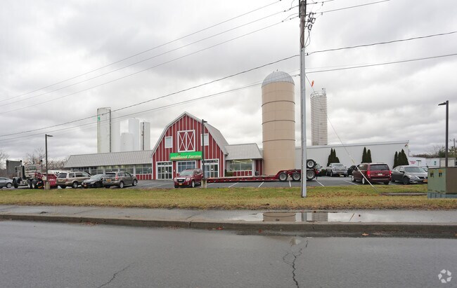
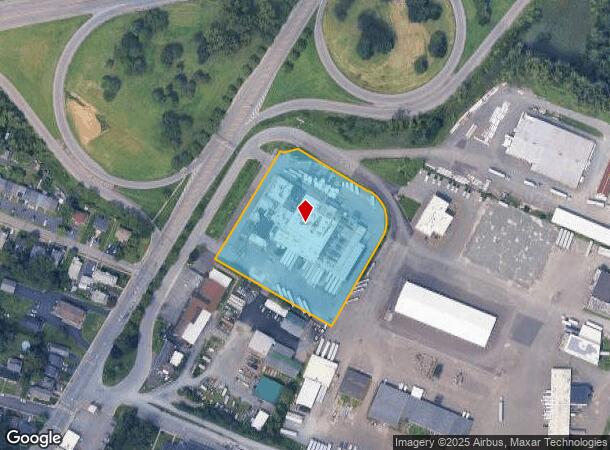
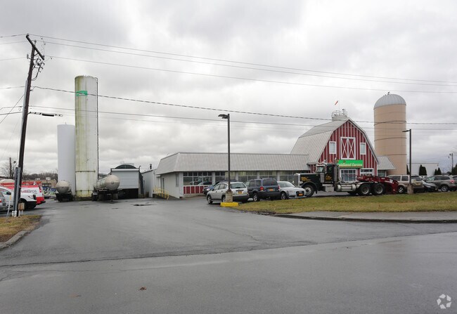
Property Record
375 Broadway, Menands, NY 12204
NEARBY LISTINGS FOR SALE OR LEASE
Property Detail
375 Broadway
012603-055-006-0002-003-003-0000
Albany
Warehouse
New York
AE
3.003
36001C0203D
3.40 AC
2025
E Outer Albany County
2024
Albany/Schenectady/Troy
013602
Albany-Schenectady-Troy, NY
49,172 SF
DEMOGRAPHICS near 375 Broadway
1 Mile
3 Mile
5 Mile
2024 Total Population
2,581
67,151
210,232
2029 Population
2,623
66,458
207,838
Pop Growth 2024-2029
+ 1.63%
(1.03%)
(1.14%)
Average Age
40
39
38
2024 Total Households
1,208
28,432
90,077
HH Growth 2024-2029
+ 1.41%
(1.08%)
(1.18%)
Median Household Inc
$66,606
$63,635
$61,256
Avg Household Size
2.10
2.10
2.10
2024 Avg HH Vehicles
1.00
1.00
1.00
Median Home Value
$174,098
$236,663
$234,341
Median Year Built
1969
1963
1957
Nearby Places
- Restaurants
- Banks
- Shops
- Fitness
- Groceries
PUBLIC TRANSPORTATION
COMMUTER RAIL
Albany-Rensselaer Amtrak Station (Adirondack - Amtrak, Empire Service - Amtrak, Ethan Allen Express - Amtrak, Lake Shore Limited - Amtrak, Maple Leaf - Amtrak, Toronto - New York - Amtrak)
DRIVE
WALK
Distance
Albany-Rensselaer Amtrak Station (Adirondack - Amtrak, Empire Service - Amtrak, Ethan Allen Express - Amtrak, Lake Shore Limited - Amtrak, Maple Leaf - Amtrak, Toronto - New York - Amtrak)
12 min
5.5 mi
AIRPORT
Albany International
DRIVE
WALK
Distance
Albany International
16 min
8.4 mi
Freight Ports
Albany, NY Port
DRIVE
WALK
Distance
Albany, NY Port
12 min
5.8 mi
Nearby Properties
Address
Land Use
TOTAL SIZE
Lot Size
Zoning
Address
Land Use
TOTAL SIZE
Lot Size
Zoning
18,340 SF
159.79 AC
04 - FARM
Address
Land Use
TOTAL SIZE
Lot Size
Zoning
120,579 SF
49.20 AC
CI
Address
Land Use
TOTAL SIZE
Lot Size
Zoning
207.50 AC
CM
Address
Land Use
TOTAL SIZE
Lot Size
Zoning
326,350 SF
11.11 AC
I
Address
Land Use
TOTAL SIZE
Lot Size
Zoning
199,495 SF
5.40 AC
CO
Address
Land Use
TOTAL SIZE
Lot Size
Zoning
11,900 SF
28.60 AC
86
Address
Land Use
TOTAL SIZE
Lot Size
Zoning
3,214 SF
412.83 AC
18
Address
Land Use
TOTAL SIZE
Lot Size
Zoning
70,548 SF
2.71 AC
DMU
Address
Land Use
TOTAL SIZE
Lot Size
Zoning
82,154 SF
3.62 AC
DMU
Address
Land Use
TOTAL SIZE
Lot Size
Zoning
220,480 SF
8.40 AC
M1
Address
Land Use
TOTAL SIZE
Lot Size
Zoning
18,144 SF
58.78 AC
25
Address
Land Use
TOTAL SIZE
Lot Size
Zoning
11,264 SF
34.83 AC
MF
Address
Land Use
TOTAL SIZE
Lot Size
Zoning
7.10 AC
CO
Address
Land Use
TOTAL SIZE
Lot Size
Zoning
85.40 AC
M1
Address
Land Use
TOTAL SIZE
Lot Size
Zoning
19,274 SF
24.80 AC
84
Address
Land Use
TOTAL SIZE
Lot Size
Zoning
223,050 SF
85.68 AC
04 - FARM
Address
Land Use
TOTAL SIZE
Lot Size
Zoning
0.06 AC
Address
Land Use
TOTAL SIZE
Lot Size
Zoning
90,174 SF
3.06 AC
R4
Address
Land Use
TOTAL SIZE
Lot Size
Zoning
586,000 SF
12.50 AC
14
Address
Land Use
TOTAL SIZE
Lot Size
Zoning
131,937 SF
17.50 AC
R3A
Address
Land Use
TOTAL SIZE
Lot Size
Zoning
2,428 SF
23.10 AC
R3A
Address
Land Use
TOTAL SIZE
Lot Size
Zoning
63,992 SF
20 AC
CM
Address
Land Use
TOTAL SIZE
Lot Size
Zoning
43,020 SF
4.50 AC
R2A
Address
Land Use
TOTAL SIZE
Lot Size
Zoning
34.12 AC
Address
Land Use
TOTAL SIZE
Lot Size
Zoning
1,465 SF
49.86 AC
OS
Address
Land Use
TOTAL SIZE
Lot Size
Zoning
7,240 SF
18.70 AC
M1
Address
Land Use
TOTAL SIZE
Lot Size
Zoning
1,536 SF
11.20 AC
M1
Address
Land Use
TOTAL SIZE
Lot Size
Zoning
8,528 SF
9.30 AC
R3A
Address
Land Use
TOTAL SIZE
Lot Size
Zoning
9,792 SF
7.98 AC
R3
The World's #1 Commercial Real Estate Marketplace
Connect with us
© 2025 CoStar Group
The information above has been obtained from sources believed reliable. While we do not doubt its accuracy we have not verified it and make no guarantee, warranty or representation about it. It is your responsibility to independently confirm its accuracy and completeness. Any projections, opinions, assumptions, or estimates used are for example only and do not represent the current or future performance of the property. The value of this transaction to you depends on tax and other factors which should be evaluated by your tax, financial, and legal advisors. You and your advisors should conduct a careful, independent investigation of the property to determine to your satisfaction the suitability of the property for your needs.