Property Record
375 County Route 1A, Oswego, NY 13126
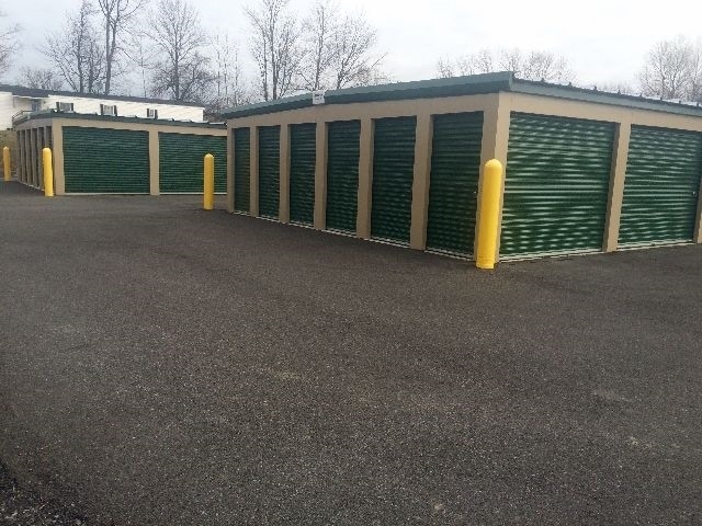
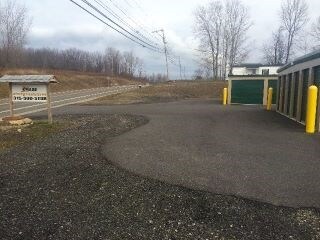
Property Detail
375 County Route 1A
Syracuse, NY
Oswego
355600-094-000-0001-027-000-0000
New York
Miscresidentialimprovement
1.76 AC
NONE
Oswego County
B and X Area of moderate flood hazard, usually the area between the limits of the 100-year and 500-year floods.
Syracuse
4,160 SF
NEARBY LISTINGS FOR SALE OR LEASE
DEMOGRAPHICS near 375 County Route 1A
1 mile
3 mile
5 mile
2025 Total Population
364
3,973
22,200
2030 Population
369
4,019
22,170
Pop Growth 2025-2030
+ 1.37%
+ 1.16%
(0.14%)
Average Age
43
43
41
2025 Total Households
152
1,720
9,516
HH Growth 2025-2030
+ 1.32%
+ 1.22%
(0.11%)
Median Household Inc
$61,071
$69,362
$61,487
Avg Household Size
2.30
2.30
2.20
2025 Avg HH Vehicles
2.00
2.00
2.00
Median Home Value
$121,875
$159,978
$147,769
Median Year Built
1982
1988
1955
Nearby Places
Map Layers
Map Styles
 Street
 Aerial
Transit
 Traffic
 Biking
Places
Listings with unknown addresses are not visible on the map
- Restaurants
- Banks
- Shops
- Fitness
- Groceries
SALE & LEASE HISTORY
LISTING DATE
SALE/LEASE

Sep 24, 2016
For Sale
Nearby Properties
Address
Land Use
TOTAL SIZE
Lot Size
Zoning
Address
Land Use
TOTAL SIZE
Lot Size
Zoning
51.50 AC
NONE
Address
Land Use
TOTAL SIZE
Lot Size
Zoning
14.11 AC
Address
Land Use
TOTAL SIZE
Lot Size
Zoning
494.36 AC
Address
Land Use
TOTAL SIZE
Lot Size
Zoning
4.50 AC
Address
Land Use
TOTAL SIZE
Lot Size
Zoning
153,253 SF
17.79 AC
CB
Address
Land Use
TOTAL SIZE
Lot Size
Zoning
111,332 SF
15.38 AC
CB
Address
Land Use
TOTAL SIZE
Lot Size
Zoning
7.89 AC
Address
Land Use
TOTAL SIZE
Lot Size
Zoning
140,380 SF
19.17 AC
CB
Address
Land Use
TOTAL SIZE
Lot Size
Zoning
28,286 SF
14.93 AC
CB
Address
Land Use
TOTAL SIZE
Lot Size
Zoning
95,923 SF
9.43 AC
CB
Address
Land Use
TOTAL SIZE
Lot Size
Zoning
14,572 SF
1.80 AC
CB
Address
Land Use
TOTAL SIZE
Lot Size
Zoning
18,851 SF
5.15 AC
IN
Address
Land Use
TOTAL SIZE
Lot Size
Zoning
30,500 SF
6.60 AC
CB
Address
Land Use
TOTAL SIZE
Lot Size
Zoning
16,368 SF
9.75 AC
NONE
Address
Land Use
TOTAL SIZE
Lot Size
Zoning
780 SF
22.58 AC
NONE
Address
Land Use
TOTAL SIZE
Lot Size
Zoning
25,840 SF
1.80 AC
CB
Address
Land Use
TOTAL SIZE
Lot Size
Zoning
23,944 SF
2.87 AC
CB
Address
Land Use
TOTAL SIZE
Lot Size
Zoning
14,641 SF
5 AC
CB
Address
Land Use
TOTAL SIZE
Lot Size
Zoning
Address
Land Use
TOTAL SIZE
Lot Size
Zoning
52,530 SF
35.85 AC
NONE
Address
Land Use
TOTAL SIZE
Lot Size
Zoning
17,350 SF
1.49 AC
CB
Address
Land Use
TOTAL SIZE
Lot Size
Zoning
16,037 SF
7.50 AC
CB
Address
Land Use
TOTAL SIZE
Lot Size
Zoning
20,978 SF
6.10 AC
IN
Address
Land Use
TOTAL SIZE
Lot Size
Zoning
182,306 SF
24 AC
IN
Address
Land Use
TOTAL SIZE
Lot Size
Zoning
4,745 SF
1.24 AC
CB
Address
Land Use
TOTAL SIZE
Lot Size
Zoning
4,480 SF
55.06 AC
IN
Address
Land Use
TOTAL SIZE
Lot Size
Zoning
62,551 SF
6.95 AC
IN
Address
Land Use
TOTAL SIZE
Lot Size
Zoning
9,040 SF
0.95 AC
CB
Address
Land Use
TOTAL SIZE
Lot Size
Zoning
0.47 AC
Address
Land Use
TOTAL SIZE
Lot Size
Zoning
3,554 SF
1.63 AC
CB
The World's #1 Commercial Real Estate Marketplace
Connect with us
© 2026 CoStar Group
The information above has been obtained from sources believed reliable. While we do not doubt its accuracy we have not verified it and make no guarantee, warranty or representation about it. It is your responsibility to independently confirm its accuracy and completeness. Any projections, opinions, assumptions, or estimates used are for example only and do not represent the current or future performance of the property. The value of this transaction to you depends on tax and other factors which should be evaluated by your tax, financial, and legal advisors. You and your advisors should conduct a careful, independent investigation of the property to determine to your satisfaction the suitability of the property for your needs.