Property Record
375 E Hanes Mill Rd, Winston Salem, NC 27105
NEARBY LISTINGS FOR SALE OR LEASE
Property Detail
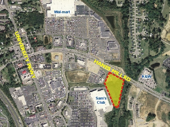
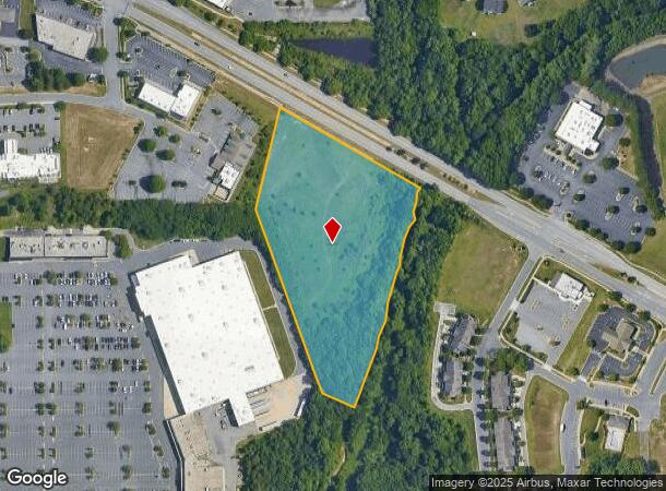
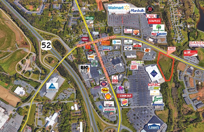
375 E Hanes Mill Rd
Winston-Salem, NC
Hanes Mill Commercial
6828-59-1546
LO:005 BL:6508
Commercialnec
Forsyth
AE
North Carolina
3710682800J
5
2024
5.34 AC
2025
NW Forsyth County
001500
Greensboro/Winston-Salem
74,290 SF
DEMOGRAPHICS near 375 E Hanes Mill Rd
1 Mile
3 Mile
5 Mile
2024 Total Population
2,835
33,516
84,366
2029 Population
2,952
34,992
88,023
Pop Growth 2024-2029
+ 4.13%
+ 4.40%
+ 4.33%
Average Age
37
38
38
2024 Total Households
1,219
13,924
32,977
HH Growth 2024-2029
+ 4.02%
+ 4.33%
+ 4.44%
Median Household Inc
$39,953
$46,461
$51,779
Avg Household Size
2.20
2.30
2.30
2024 Avg HH Vehicles
2.00
2.00
2.00
Median Home Value
$153,924
$157,015
$173,121
Median Year Built
1986
1980
1978
Nearby Places
Map Layers
Map Styles
 Street
 Aerial
- Restaurants
- Banks
- Shops
- Fitness
- Groceries
PUBLIC TRANSPORTATION
AIRPORT
Piedmont Triad International
DRIVE
WALK
Distance
Piedmont Triad International
41 min
25.8 mi
Freight Ports
Virginia Port Authority - Richmond
DRIVE
WALK
Distance
Virginia Port Authority - Richmond
268 min
229.4 mi
SALE & LEASE HISTORY
LISTING DATE
SALE/LEASE

May 12, 2017
For Sale
Aug 10, 2017
For Lease
Nearby Properties
Address
Land Use
TOTAL SIZE
Lot Size
Zoning
Address
Land Use
TOTAL SIZE
Lot Size
Zoning
412,075 SF
94.76 AC
CPO,GI,RS9
Address
Land Use
TOTAL SIZE
Lot Size
Zoning
329,963 SF
58.84 AC
RM18-S
Address
Land Use
TOTAL SIZE
Lot Size
Zoning
153,937 SF
34.63 AC
RM12-S
Address
Land Use
TOTAL SIZE
Lot Size
Zoning
245,828 SF
28.02 AC
GB
Address
Land Use
TOTAL SIZE
Lot Size
Zoning
152,968 SF
32.40 AC
RM18
Address
Land Use
TOTAL SIZE
Lot Size
Zoning
85,354 SF
29.13 AC
RM18-S
Address
Land Use
TOTAL SIZE
Lot Size
Zoning
178,192 SF
28.15 AC
RM18
Address
Land Use
TOTAL SIZE
Lot Size
Zoning
91,905 SF
21.18 AC
RM18-S
Address
Land Use
TOTAL SIZE
Lot Size
Zoning
106,821 SF
14.95 AC
RM12-S
Address
Land Use
TOTAL SIZE
Lot Size
Zoning
224,895 SF
31.67 AC
HB-S
Address
Land Use
TOTAL SIZE
Lot Size
Zoning
209,521 SF
20.73 AC
HB-S,RS9
Address
Land Use
TOTAL SIZE
Lot Size
Zoning
741,857 SF
53.71 AC
GB-L
Address
Land Use
TOTAL SIZE
Lot Size
Zoning
12,132 SF
57.50 AC
RM18
Address
Land Use
TOTAL SIZE
Lot Size
Zoning
711,274 SF
38.24 AC
LI
Address
Land Use
TOTAL SIZE
Lot Size
Zoning
120,256 SF
43.62 AC
GB-S,IP
Address
Land Use
TOTAL SIZE
Lot Size
Zoning
90,740 SF
17.28 AC
RM18
Address
Land Use
TOTAL SIZE
Lot Size
Zoning
111,873 SF
23.10 AC
RM18
Address
Land Use
TOTAL SIZE
Lot Size
Zoning
99,460 SF
17.17 AC
RM18
Address
Land Use
TOTAL SIZE
Lot Size
Zoning
113,060 SF
16.61 AC
HB-S,RS9
Address
Land Use
TOTAL SIZE
Lot Size
Zoning
34,316 SF
6.50 AC
GB
Address
Land Use
TOTAL SIZE
Lot Size
Zoning
92,721 SF
22.79 AC
HB
Address
Land Use
TOTAL SIZE
Lot Size
Zoning
81,392 SF
15.76 AC
GB
Address
Land Use
TOTAL SIZE
Lot Size
Zoning
89,957 SF
14.65 AC
RM18
Address
Land Use
TOTAL SIZE
Lot Size
Zoning
89,408 SF
10.57 AC
GI
Address
Land Use
TOTAL SIZE
Lot Size
Zoning
95,375 SF
20.15 AC
RS9
Address
Land Use
TOTAL SIZE
Lot Size
Zoning
449,539 SF
24.86 AC
GI
Address
Land Use
TOTAL SIZE
Lot Size
Zoning
54,110 SF
15.08 AC
IP-S
Address
Land Use
TOTAL SIZE
Lot Size
Zoning
56,653 SF
13.83 AC
RM12-S,RM1
Address
Land Use
TOTAL SIZE
Lot Size
Zoning
132,881 SF
22.93 AC
GI,HB-S
Address
Land Use
TOTAL SIZE
Lot Size
Zoning
169,173 SF
12 AC
GB
The World's #1 Commercial Real Estate Marketplace
Connect with us
© 2026 CoStar Group
The information above has been obtained from sources believed reliable. While we do not doubt its accuracy we have not verified it and make no guarantee, warranty or representation about it. It is your responsibility to independently confirm its accuracy and completeness. Any projections, opinions, assumptions, or estimates used are for example only and do not represent the current or future performance of the property. The value of this transaction to you depends on tax and other factors which should be evaluated by your tax, financial, and legal advisors. You and your advisors should conduct a careful, independent investigation of the property to determine to your satisfaction the suitability of the property for your needs.