Property Record
375 Mitchell St, Oswego, NY 13126
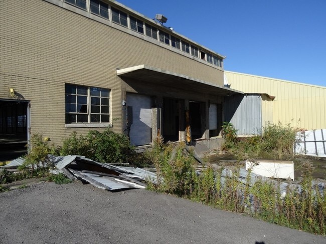
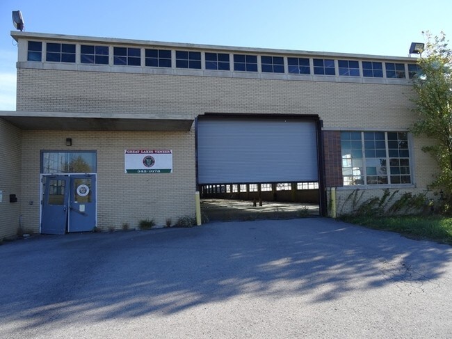
Property Detail
375 Mitchell St
Syracuse, NY
OSWEGO
351200-111-069-0001-001-000-0000
New York
Industrialgeneral
21.85 AC
IN
Oswego County
B and X Area of moderate flood hazard, usually the area between the limits of the 100-year and 500-year floods.
Syracuse
36,361 SF
NEARBY LISTINGS FOR SALE OR LEASE
DEMOGRAPHICS near 375 Mitchell St
1 mile
3 mile
5 mile
2025 Total Population
533
18,862
28,501
2030 Population
539
18,816
28,546
Pop Growth 2025-2030
+ 1.13%
(0.24%)
+ 0.16%
Average Age
42
41
39
2025 Total Households
236
8,166
10,672
HH Growth 2025-2030
+ 1.27%
(0.21%)
(0.05%)
Median Household Inc
$57,727
$57,828
$62,252
Avg Household Size
2.20
2.20
2.20
2025 Avg HH Vehicles
2.00
2.00
2.00
Median Home Value
$129,464
$147,191
$150,649
Median Year Built
1984
1950
1958
Nearby Places
Map Layers
Map Styles
 Street
 Aerial
Layers
 Traffic
 Biking
Places
Listings with unknown addresses are not visible on the map
- Restaurants
- Banks
- Shops
- Fitness
- Groceries
SALE & LEASE HISTORY
LISTING DATE
SALE/LEASE

Sep 24, 2016
For Sale
Jul 19, 2017
For Sale
Nearby Properties
Address
Land Use
TOTAL SIZE
Lot Size
Zoning
Address
Land Use
TOTAL SIZE
Lot Size
Zoning
54.93 AC
NONE
Address
Land Use
TOTAL SIZE
Lot Size
Zoning
51.50 AC
NONE
Address
Land Use
TOTAL SIZE
Lot Size
Zoning
50.74 AC
NONE
Address
Land Use
TOTAL SIZE
Lot Size
Zoning
Address
Land Use
TOTAL SIZE
Lot Size
Zoning
600 SF
27.36 AC
IN
Address
Land Use
TOTAL SIZE
Lot Size
Zoning
166,923 SF
3.27 AC
TD
Address
Land Use
TOTAL SIZE
Lot Size
Zoning
494.36 AC
NONE
Address
Land Use
TOTAL SIZE
Lot Size
Zoning
13,576 SF
4.54 AC
IN
Address
Land Use
TOTAL SIZE
Lot Size
Zoning
5,604 SF
0.33 AC
SR
Address
Land Use
TOTAL SIZE
Lot Size
Zoning
192,667 SF
81.04 AC
SR
Address
Land Use
TOTAL SIZE
Lot Size
Zoning
Address
Land Use
TOTAL SIZE
Lot Size
Zoning
36,360 SF
9.04 AC
PD
Address
Land Use
TOTAL SIZE
Lot Size
Zoning
4.50 AC
Address
Land Use
TOTAL SIZE
Lot Size
Zoning
225,081 SF
13.84 AC
TN2
Address
Land Use
TOTAL SIZE
Lot Size
Zoning
153,253 SF
17.79 AC
CB
Address
Land Use
TOTAL SIZE
Lot Size
Zoning
42,320 SF
4.88 AC
TB
Address
Land Use
TOTAL SIZE
Lot Size
Zoning
91,452 SF
1.54 AC
TB
Address
Land Use
TOTAL SIZE
Lot Size
Zoning
37,942 SF
0.46 AC
TB
Address
Land Use
TOTAL SIZE
Lot Size
Zoning
111,332 SF
15.38 AC
CB
Address
Land Use
TOTAL SIZE
Lot Size
Zoning
7.89 AC
Address
Land Use
TOTAL SIZE
Lot Size
Zoning
459 SF
3.63 AC
TN2
Address
Land Use
TOTAL SIZE
Lot Size
Zoning
87,469 SF
16.11 AC
TN2
Address
Land Use
TOTAL SIZE
Lot Size
Zoning
20,460 SF
3.47 AC
IN
Address
Land Use
TOTAL SIZE
Lot Size
Zoning
140,380 SF
19.17 AC
CB
Address
Land Use
TOTAL SIZE
Lot Size
Zoning
28,286 SF
14.93 AC
CB
Address
Land Use
TOTAL SIZE
Lot Size
Zoning
118,289 SF
9.02 AC
PD
Address
Land Use
TOTAL SIZE
Lot Size
Zoning
14,572 SF
1.80 AC
CB
Address
Land Use
TOTAL SIZE
Lot Size
Zoning
95,923 SF
9.43 AC
CB
Address
Land Use
TOTAL SIZE
Lot Size
Zoning
51,000 SF
3.80 AC
PD
The World's #1 Commercial Real Estate Marketplace
Connect with us
© 2026 CoStar Group
The information above has been obtained from sources believed reliable. While we do not doubt its accuracy we have not verified it and make no guarantee, warranty or representation about it. It is your responsibility to independently confirm its accuracy and completeness. Any projections, opinions, assumptions, or estimates used are for example only and do not represent the current or future performance of the property. The value of this transaction to you depends on tax and other factors which should be evaluated by your tax, financial, and legal advisors. You and your advisors should conduct a careful, independent investigation of the property to determine to your satisfaction the suitability of the property for your needs.